
Weather Maps (interactive!) on That Blue Square Thing. A bit inspired by a tweet from Noel Jenkins and by some Year 3/4 work I saw at my son's primary school, I dug out some old drag and drop html techniques and came up with an interactive weather map.
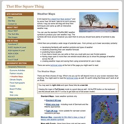
You can use the standard 70s/80s BBC weather symbols to produce your own weather map. Geograph the British Isles – combining mapping, photography and gaming in the classroom. Geograph British Isles combines mapping with photography and gaming challenges to encourage practical interaction with maps and of the British Isles. Photographs for every square kilometre of the British Isles Users of Ordnance Survey maps will know that Ordnance Survey maps divide up the geographical area into squares for ease of reference by users sharing locations – called the grid reference. Running app and fitness community.