
FAQ. Firmware versions in green are available in stable and/or dev for download Firmware versions in gray do not have official CHDK releases.

Check porting status here For the development status of not-yet-supported cameras, see For Developers. It is likely that any Canon Powershot based on the DIGIC II, DIGIC III or DIGIC 4 platforms can be supported, although it is impossible to be sure until someone starts work on a particular model. If your camera model is not listed here then there is no CHDK for it at the present time ! See also Unsupported Cameras, Adding support for a new camera and Q. My camera isn't ported yet. For camera models currently in development see For Developers For technical reasons some cameras will never be supported by CHDK. Canon DSLRs. Q. Edit A. A port of a new camera model happens if and only if there is a developer who has the camera and sufficient time, motivation and skill to complete the port. Q. A. Creating the ver.req or vers.req file Windows based systems. UAV Mapping Post Processing Tutorial 1 (VisualSFM, CMVS) Collecting Your Own Aerials.
An exciting possibility: increasingly affordable hardware and sophisticated software should make it available for anyone to collect high-resolution georegistered aerial imagery.
Beyond just viewing the result, with the use of photogrammetry and ground control points, the imagery could provide a base for collecting all the 2D and 3D features that are the last-mile problem in modeling and visualizing the whole world. UAVs As of 2013, there is a wide range of UAVs that can capture imagery, from toys at the low-end to military drone surveying at the high end. French company Pict'Earth gave a good presentation in 2008, A NeoGeographical Approach to Aerial Image Acquisition and Processing, which explains how UAVs opens a way to do something new and important: Site Specific Base Maps. Popular platforms include RC helicopters (gas and electric), Quadrotors, and regular fixed-wing (and flying wing) planes, generally of a modest size.
Kites and Balloons Processing the Imagery. Sample Digital Orthophoto Images. 2D image post-processing techniques and algorithms. A number of people on this site are using their vehicles for aerial mapping.
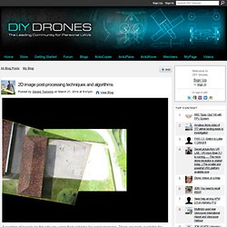
There are tools available for image stitching, which basically produces a rough idea about what the terrain looks like from above. Image stitching does not compensate for perspective and usually contains lots of artifacts. The reason why some older tools don't really work that well is because they rely on older algorithms for image matching which are not as scale or rotation invariant. For example, have a look at the image below: Here we see two images that have been matched together using a "SIFT" algorithm. Now here's the reason why it's important: if you understand how this algorithm works, you can also get a better understanding how to shoot your images and what to prevent to get good matches. The second image shows the matching pairs of features after the fundamental matrix was established. The image at the top wasn't created with the fundamental matrix, it was created using a "homography matrix".
PLOTS Map Knitter.