
Travel to Machu Picchu. Travel to Machu Picchu By Greg Rodgers Machu Picchu has become the largest backpacking attraction in South America and it’s no surprise.

TREKKING MT. RORAIMA: VENEZUELA'S LOST WORLD. MT.

RORAIMA, located on Venezuela's border with Brasil and Guiana, is the highest of the tepuis (flat-topped mountains) in the Gran Sabana, topping out at 2810 m. It was the inspiration for Sir Arthur Conan Doyle's novel "The Lost World", which has made it the most famous of all the tepuis. Roraima has become a popular trek, completely non-technical, but moderately strenuous even with porters to carry most of your gear, and more than moderately strenuous if you are going without porters.
The Venezuelan park service, INPARQUES, requires that you take a guide; we recommend that you hire porters, too, for not only will the use of porters make your trip easier, you will be helping the Pemón Indians earn cash income that is otherwise hard to come by. Training Brazilian Jiu Jitsu in Brazil. In one of my previous posts, I wrote about the perfect travel strategy.

The idea is doing something fulfilling and rewarding while living abroad for an extended time. The strategy is two-fold: one, nurture a skill you can apply in life, and two, create a balanced routine which is important for staying sane when living alone in a new place without a social circle. When I was living in Rio, I applied this strategy by training Brazilian Jiu Jitsu almost every day.
Iguazu Falls. The name "Iguazu" comes from the Guarani or Tupi words "y" [ɨ], meaning "water", and "ûasú "[waˈsu], meaning "big".[2] Legend has it that a god planned to marry a beautiful woman named Naipí, who fled with her mortal lover Tarobá in a canoe.

In rage, the god sliced the river, creating the waterfalls and condemning the lovers to an eternal fall.[2] The first European to "find" the falls was the Spanish conquistador Álvar Núñez Cabeza de Vaca in 1541. Video Clip: Panoramic view of the falls Geography[edit] Union Fall, Iguazu's largest cataract. Brazil-Map.jpg (JPEG-bild, 1106x1436 pixlar) Mount Roraima in Guyana, Venezuela and Brazil: Vacation Ideas in South America. Mount Roraima is a tepui tabletop mountain that stands right on the junction of three South American countries: Guyana, Venezuela and Brazil.

San Agustín arkeologiska park. Tiwanaku. Coordinates: 16°33′17″S 68°40′24″W / 16.55472°S 68.67333°W / -16.55472; -68.67333 Tiwanaku (Spanish: ''Tiahuanaco and Tiahuanacu'') is a Pre-Columbian archaeological site in western Bolivia, South America.
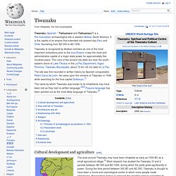
It is the capital of an empire that extended into present-day Peru and Chile, flourishing from AD 300 to AD 1000. Salar de Uyuni. Ciudad Perdida. A boulder with carved markings, believed to be a map of the area around Ciudad Perdida.

View of the central area of the city. Wooden structures once stood on the stone platforms. Ciudad Perdida (Spanish for "Lost City") is the archaeological site of an ancient city in Sierra Nevada, Colombia. It is believed to have been founded about 800 AD, some 650 years earlier than Machu Picchu. Cotopaxi National Park. Media related to Cotopaxi National Park at Wikimedia Commons.

Inca Trail to Machu Picchu. Much of the trail is of original Incan construction The Inca Trail to Machu Picchu (also known as Camino Inca or Camino Inka) consists of three overlapping trails: Mollepata, Classic, and One Day.

Mollepata is the longest of the three routes with the highest mountain pass and intersects with the Classic route before crossing Warmiwañusqa ("dead woman"). Located in the Andes mountain range, the trail passes through several types of Andean environments including cloud forest and alpine tundra. Settlements, tunnels, and many Incan ruins are located along the trail before ending the terminus at the Sun Gate on Machu Picchu mountain. The two longer routes require an ascent to beyond 4,200 metres (13,800 ft) above sea level, which can result in altitude sickness.
Concern about overuse leading to erosion has led the Peruvian government to place a limit on the number of people who may hike this trail per season, and to sharply limit the companies that can provide guides. Classic trail[edit] Cartagena, Colombia. Cartagena or Cartagena de Indias (Spanish pronunciation: [kartaˈxena ðe ˈindjas], "Cartagena of the Indies"), is a city on the northern coast of Colombia in the Caribbean Coast Region and capital of the Bolívar Department.

The port city had a population of 892,545 as of the 2005 census. It is the fifth-largest city in Colombia and the second largest in the region, after Barranquilla. The Cartagena urban area is also the fifth-largest urban area in the country. Economic activities include maritime and petrochemicals industry, as well as tourism. The city was founded on June 1, 1533, and named after Cartagena, Spain. History[edit] Quito.
Quito (/ˈkito/; officiellt spanskt namn: San Francisco de Quito) är huvudstad i Ecuador. Quito ligger omkring 25 kilometer söder om ekvatorn. På grund av stadens höga läge och närheten till ekvatorn har Quito ett milt klimat året runt. Cusco. Namnet Cusco (Quechua Qusqu) betyder navel på inkaspråket quechua. Historia[redigera | redigera wikitext] Cusco var huvudstad och kulturellt och religiöst centrum för Inkariket. Sistema Sac Actun. Sistema Sac Actun (from Spanish and Yucatec Maya meaning "White Cave System") is an underwater cave system situated along the Caribbean coast of the Yucatán Peninsula with passages to the north and west of the village of Tulum.
Exploration started from Gran Cenote 5 kilometers (3.1 mi) west of Tulum. The whole of the explored cave system lies within the Municipality of Tulum (state of Quintana Roo). In early 2007, the underwater cave Sistema Nohoch Nah Chich was connected into and subsumed into Sac Actun making it the longest surveyed underwater cave system in the world[3] for some months. Sac Actun measures 230.8 kilometers (143.4 mi) (after connecting Sistema Aktun Hu with 34 kilometers (21 mi) in January 2011) and is second surpassed by Sistema Ox Bel Ha at 256.7 kilometers (159.5 mi).
Tayrona National Natural Park. Playa Brava in Tayrona National Natural Park. Pantanal. Pantanal Pantanal är ett enormt vidsträckt våtmarksområde som täcker delar av Brasilien, Paraguay och Bolivia. Med en areal på uppemot 200 000 km² under regnperioden är Pantanal världens största våtmark. Vegetationen domineras av gräsmark och savann som översvämmas av vatten som i huvudsak kommer från Paraguayfloden.
Pantanal är därmed ett utmärkt exempel på ett ekosystem i översvämmad gräsmark och savann.