
Dust Bowl. Oldie But Goodie “And the great owners, who must lose their land in an upheaval, the great owners with access to history, with eyes to read history and to know the great fact: when property accumulates in too few hands it is taken away.
And that companion fact: when a majority of the people are hungry and cold they will take by force what they need. And the little screaming fact that sounds through all history: repression works only to strengthen and knit the repressed.” – John Steinbeck – Grapes of Wrath John Steinbeck wrote his masterpiece The Grapes of Wrath at the age of 37 in 1939, at the tail end of the Great Depression. Steinbeck won the Nobel Prize and Pulitzer Prize for literature. Steinbeck became the champion of the working class. Okies and the Land of Milk & Honey “How can you frighten a man whose hunger is not only in his own cramped stomach but in the wretched bellies of his children?
NASS - Kansas Publications and Press Releases.
The Land Institute. Farm Crops by County Reference. Compare reviews & ratings. Kansas Department of Agriculture. 20055.pdf. Regional Interpretation - Great Plains. Great Plains | Intermountain West | Southwest | Texas and Oklahoma | Other This document is also available in Adobe Acrobat format NRI Rangeland Resource Assessment - Great Plains Regional Interpretation (PDF; 3.4 MB) Overview The Great Plains region include the most productive rangeland in the United States due in large part to generally reliable summer precipitation, a long growing season, and deep, fertile soils.
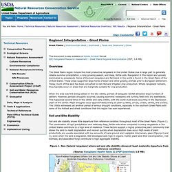
Rangeland in this region are typically dominated by grasslands. Some of the best rangeland and farmland in the world is found in the Great Plains of the United States. When the area was first being settled in the late 1800s, periods of adequate rainfall attracted large numbers of settlers. Soil and Site Stability Soil and site stability shows little departure from reference condition throughout most of the Great Plains (Figure 1). Some of the southwestern parts of this region showed more significant departures from reference conditions for soil and site stability. Kansas Wind Energy Projects - Utility Scale. Kansas%20Average%20Wind%20Speed. Ks_50m_800.
Ogallala Aquifer. About 27 percent of the irrigated land in the United States overlies the aquifer, which yields about 30 percent of the ground water used for irrigation in the United States.
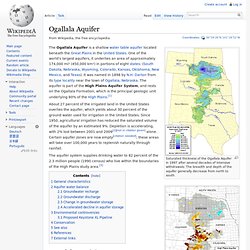
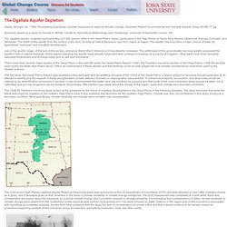
Since 1950, agricultural irrigation has reduced the saturated volume of the aquifer by an estimated 9%. Depletion is accelerating, with 2% lost between 2001 and 2009[2][not in citation given] alone. Certain aquifer zones are now empty[citation needed]; these areas will take over 100,000 years to replenish naturally through rainfall. The aquifer system supplies drinking water to 82 percent of the 2.3 million people (1990 census) who live within the boundaries of the High Plains study area.[3] General characteristics[edit] The deposition of aquifer material dates back 2 to 6 million years, from the late Miocene to early Pliocene ages when the southern Rocky Mountains were still tectonically active.
Aquifer water balance[edit] An aquifer is a groundwater storage reservoir in the water cycle. Groundwater recharge[edit] Ogallala Aquifer. The Ogallala Aquifer Depletion. Glantz, Michael, ed., 1989: Forecasting by analogy: societal responses to regional climatic change.
Summary Report, Environmental and Societal Impacts Group NCAR, 77 pp. Summary based on a study by Donald A. Wilhite, Center for Agricultural Meteorology and Climatology, University of Nebraska, Lincoln, NE. The Ogallala Aquifer underlies approximately 225,000 square miles in the Great Plains region, particularly in the High Plains of Texas, New Mexico, Oklahoma, Kansas, Colorado, and Nebraska. The depth of the aquifer from the surface of the land, its reate of natural thickness, vary from region to region. Use of the aquifer began at the turn of the century, and since World War II reliance on it has steadily increased.
There have been several major studies of the Great Plains in the past fifty years; the Great Plains Report (1936), the Travelers Insurance studies of the Great Plains (1958-59) and the most recent Six-State High Plains Study (1982). Is the drawdown a national problem? USGS - Water Resources in Kansas.