
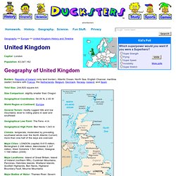
United Kingdom capital, history, map, flag, and people. Geography >> Europe >> United Kingdom History and Timeline Capital: London Population: 63,047,162 Geography of United Kingdom Borders: Republic of Ireland (only land border), Atlantic Ocean, North Sea, English Channel, maritime (water) borders with France, the Netherlands, Belgium, Denmark, Norway, Iceland, and Spain Total Size: 244,820 square km Size Comparison: slightly smaller than Oregon Geographical Coordinates: 54 00 N, 2 00 W World Region or Continent: Europe General Terrain: mostly rugged hills and low mountains; level to rolling plains in east and southeast Geographical Low Point: The Fens -4 m Geographical High Point: Ben Nevis 1,343 m Climate: temperate; moderated by prevailing southwest winds over the North Atlantic Current; more than one-half of the days are overcast Major Cities: LONDON (capital) 8.615 million; Birmingham 2.296 million; Manchester 2.247 million; West Yorkshire 1.541 million; Glasgow 1.166 million (2009) Palace of Westminster Economy of United Kingdom Tower of London.
United Kingdom Facts and Pictures. Facts about Britain. Geography of the UK. The official title of the UK is the United Kingdom of Great Britain and Northern Ireland .
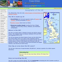
Great Britain (the formerly separate realms of England and Scotland, and the principality of Wales. ) Northern Ireland (also known as Ulster) Numerous smaller islands including the Isle of Wight, Anglesey, and the Scilly, Orkney, Shetland, and Hebridean archipelagos. The UK is an island nation in Western Europe just off the coast of France. The mainland areas lie between latitudes 49°N and 59°N and longitudes 8°W to 2°E. The UK lies between the North Atlantic Ocean and the North Sea, and comes within 35 km (22 miles) of the northwest coast of France, from which it is separated by the English Channel. Northern Ireland shares a 360 km international land boundary with the Republic of Ireland. The UK has a total area of approximately 245,000 km², almost a quarter-of-a-million square kilometres. The UK is made up of several islands.
The UK is bordered by four seas: Lakes Find out more about UK Rivers. Japan capital, history, map, flag, and people. Geography >> Asia >> Japan History and Timeline Capital: Tokyo Population: 127,368,088 The Geography of Japan Borders: Japan is an island nation in East Asia surrounded by the Pacific Ocean on one side and the Sea of Japan (East Sea) on the other side.
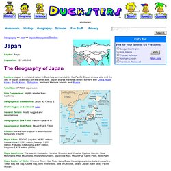
Japan shares maritime (water) borders with China, North Korea, South Korea, Philippines, Northern Mariana Islands, and Russia. Total Size: 377,835 square km Size Comparison: slightly smaller than California Geographical Coordinates: 36 00 N, 138 00 E World Region or Continent: Asia General Terrain: mostly rugged and mountainous Geographical Low Point: Hachiro-gata -4 m Geographical High Point: Mount Fuji 3,776 m Climate: varies from tropical in south to cool temperate in north Major Cities: TOKYO (capital) 36.507 million; Osaka-Kobe 11.325 million; Nagoya 3.257 million; Fukuoka-Kitakyushu 2.809 million; Sapporo 2.673 million (2009) Mount Fuji. Japan Geography.
Geography: Nature and Climate - FAQ - Kids Web Japan. Japan Geography. Japan Facts and Pictures.