
Storymaps. Maps Live: Visualizing Maps Engine Data on JavaScript Maps. MyGPSFiles: The GPS tracks reader. Map Creator. Let’s Make a Map. In this tutorial, I’ll cover how to make a modest map from scratch using D3 and TopoJSON.
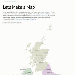
I’ll show you a few places where you can find free geographic data online, and how to convert it into a format that is both efficient and convenient for display. I won’t cover thematic mapping, but the map we’ll make includes labels for populated places and you can extend this technique to geographic visualizations such as graduated symbol maps and choropleths. Without further ado, here’s the map: Shown are the four constituent countries of the United Kingdom: Scotland, Northern Ireland, Wales and England.
As maps go, it’s not particularly interesting, but the simplicity should serve adequately to demonstrate the basics of map-making. #Finding Data The first task for any map is finding geometry. Unfortunately, government data can sometimes be hard to find or use. For a crowdsourced alternative, GeoCommons is a platform for sharing geographic datasets. #Installing Tools brew install gdal. TileMill. Map Your Adventures With This Interactive Travel Visualizer. You can always track where in the world you’ve been with old school pins on a map board, but if you want a more sophisticated, digital version, there’s Visits, a program that turns your personal globetrotting history into a series of interactive online map-timelines.
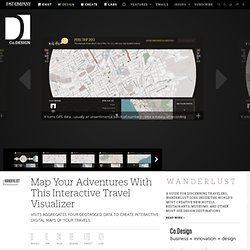
It turns GPS data--usually an unsentimental batch of numbers--into a means of recording memories. V.isits.in is a research project by Alice Thudt, Dominkus Baur and professor Sheelagh Carpendale, at the University of Calgary, which aggregates geotags from your Flickr albums, data from OpenPath, and Google Location Histories to visualize where you've been and how long you stayed there. (The program runs locally on Visits' browser, so no private data is uploaded to their servers.) Visits. ¿Cuáles son las mejores o más usadas aplicaciones web para la creación de mapas? Odyssey.js. Software. MapTube. 3D Map Creator – Adobe Photoshop 10+ Actions and Graphics Tools.
Now is no more need to stay days in front of computer to draw realistic 3D maps, from urban map to route or golf maps, football fields, isometric or classic paper maps.
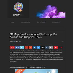
Is no need to have an expensive 3D software license. Create your own 3D maps with only one click! Every shape is possible and delivers a professional result. The following Adobe Photoshop add-ons are great for web graphics, info graphics or presentations. Even the following Adobe Photoshop actions are premium add-ons, the small prices (5$ – 8$) are a great save actually.
GeoTagged Photo Mapping - Android Apps on Google Play. Professional geotagging solution - all you need to geotag photos taken by your EXTERNAL camera (DSLR or compact one).
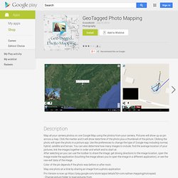
Supports JPG & RAW file formats. * Pixelmania.nl award (Android version) ** Macworld - Geotagging App Of The Year 2010 (iPhone version) ** PhotoPlus magazine BEST ON TEST Award! (iPhone version) * ● See Geotag Photos video at ● English, German, French and Czech localization! This Lite version supports all functions of full version, except automatic logging. This Android app works like GPS Data Logger - it logs your positions during your trip.
When you return from your trip, you can synchronize logged data with our desktop application and geotag photos taken by your camera. Let us know what you would like to see on the next version – we’ll be happy to look for ways to implement it for you! Tripline Tutorial 1: Basic Map Creation. Convert GPX, DXF, SHP, KML, CSV, other formats with ExpertGPS. Pt-br:Mapillary. Mapillary (mapillary.com) é um serviço de compartilhamento de fotos georreferenciadas desenvolvido por uma startup localizada em Malmö, Suécia.
Seus idealizadores querem representar o mundo todo com fotos[1][2], não apenas ruas. Acreditam num modelo de serviço em que pessoas contribuirão capturando fotos com seus dispositivos móveis, invés daquele usado pela Google, que usa carros próprios equipados com plataforma no teto[1]. Segundo eles, o conhecimento local é quase imbatível, e as pessoas sabem o que realmente importa na captura de uma foto[1].
Elas se interessam por minúcias e isso pode contribuir para um sistema que represente o mundo com alto nível de detalhes[1]. Por outro lado, convém que a "inteligência" fique a cargo do software, tornando o uso das aplicações de coleta de dados super simples para o usuário colaborador. GMapCreator Licence Agreement. MapTube. Map Stack: Maps for All. Map Stack: Maps for All Good-looking maps used to be the domain of experts.
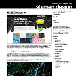
That’s been changing quite a bit in the last few years, and it’s easier than ever now for developers to access mapping data (the recent State of the Map US conference was a great place to hear about this). Never content to leave well enough alone, we thought we’d kick this sideways a bit and make it easy for the rest of us to make some great stuff. We call it Map Stack. It's a bit like Instagram for maps. The maps.stamen.com project was designed to let people easily use Open Street Map data in their own applications, and to provide well-designed map styles that would raise the bar for what people expect from open data. Watercolor punched through by satellite imagery from MapBox. Urban Apps: 13 Interactive City Maps, Tools & Guides.