
Breaking3zero sur Twitter : "Décès de #GeoffreyLewis, 79 ans. Spécialiste des seconds rôles, fidèle à Eastwood et père de Juliette. #RIP. Doris stricher sur Twitter : "RT @loouisfernandes Les espaces de l'artiste Esther Stocker brisent l'équilibre optique #géométrie #abstraction. A big chunk of the Sierra Nevada caught fracturing on video. If you like geology, you’re used to relying on an active imagination.
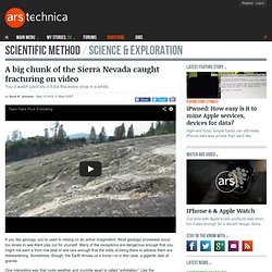
Most geologic processes occur too slowly to see them play out for yourself. Many of the exceptions are dangerous enough that you might not want a front row seat or are rare enough that the odds of being there to witness them are disheartening. Sometimes, though, the Earth throws us a bone—or in this case, a gigantic slab of granite. One interesting way that rocks weather and crumble apart is called “exfoliation.”
Like the skin-scrubbing technique, this involves the outermost layers of exposed igneous or metamorphic bedrock sloughing off in a sheet. We’re not entirely sure just what drives the peeling of an outcrop’s skin like this, but the classic explanation is that it’s the result of bringing rocks that formed at great pressure up to the surface. Ethz.focproject. The Network of Global Corporate Control Stefania Vitali, James B. Glattfelder, Stefano Battiston* Chair of Systems Design, ETH Zurich, Zurich, Switzerland Transnational corporations (TNC) are the main players in today's economy.
The control over a corporation measures the potential influence that a shareholder has in its business strategy. This work is the first global analysis of the control of transnational corporations. Follow us on Twitter ... Download the 737 top holders list as an Excel Spreadsheet or explore it with Google document . The work was supported by the FET-OPEN project FOC "Forecasting Financial Crises" Google Maps The Grand Canyon And Other Amazing Photos From This Week. Science,colin_lecher,art,google,google_maps,google_street_view,images,images_of_the_week,iotw,nasa,photography,photojournalism,saturn,science science Including a pepper-spraying iPhone, an illustrated guide to eating a Triceratops, and more Google At The Grand Canyon Google is bringing its street-view empire to the Grand Canyon.
The cameras aren't the coolest, but seeing a panoramic of the Grand Canyon from anywhere? Awesome. Click here to enter the gallery To comment, please Login . Popular Science+ For iPad Each issue has been completely reimagined for your iPad. Map your Twitter friends. Google Earth - Google Maps : visite guidée. New generation GPS satellite starts tests in Colo. A $5.5 billion upgrade to the Global Positioning System moved a step closer to launch this week when a prototype arrived at a Lockheed Martin complex in Colorado to begin months of tests.
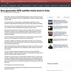
It's the guinea pig for a new generation of GPS satellites, called Block III, that's expected to make military and civilian receivers more accurate, powerful and reliable. They're also part of an international effort to allow civilian receivers to use signals from U.S., European, Russian and perhaps other satellite navigation systems. Real-Time Ship Tracking on Google Maps. Scientists confirm Himalayan glacial melting. Glaciers in the Himalayas have shrunk by as much as a fifth in just 30 years, scientists have claimed in the first authoritative confirmation of the effects of climate change on the region.
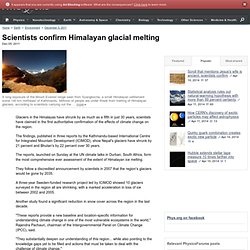
The findings, published in three reports by the Kathmandu-based International Centre for Integrated Mountain Development (ICIMOD), show Nepal's glaciers have shrunk by 21 percent and Bhutan's by 22 percent over 30 years. The reports, launched on Sunday at the UN climate talks in Durban, South Africa, form the most comprehensive ever assessment of the extent of Himalayan ice melting. They follow a discredited announcement by scientists in 2007 that the region's glaciers would be gone by 2035.
A three-year Sweden-funded research project led by ICIMOD showed 10 glaciers surveyed in the region all are shrinking, with a marked acceleration in loss of ice between 2002 and 2005. Another study found a significant reduction in snow cover across the region in the last decade. Chili : Des photos pour dénoncer les violences contre une communauté mapuche. Guyane. La fusée russe Soyouz a décollé - Monde-France. Dynamiques d'un grand pays émergent, le Brésil. Terre de feu chilienne. L'exploit de six militaires français - Monde.
Geovisite Geolocalisation Tracking Geolocalizzazione Geo visite Geo localização. LA CORSE GEOLOGIQUE. Un peu plus loin, les plissements du marbre apparaissent très clairement en bord de route.
Ces plis isoclinaux sont très serrés et des lentilles vertes de prasinite sont visibles dans le marbre. Excel To KML. Western United States only, in a number of formats.

Used in place of Latitude and Longitude or Position. The Quarter/Quarter closest to our example position 39° 18' 40.58" N 102° 17' 30.47" W is the SE 1/4 of the NW 1/4 of Section 35, Range 44 West, Township 8 South, Sixth Meridian, Colorado. Un nouveau réseau de stations GPS pour mesurer les mouvements de l’écorce terrestre. Atelier cartographique multiplateforme : RasterChart2BSB.
GoogleMaps. Méditerranée occidentale: cartes muettes gratuites, cartes vierges gratuites, fonds de cartes gratuits. Top 10 Posts on Google Maps Mania 2009. Here are the top 10 posts on Google Maps Mania in 2009.
These are the ten posts that received the most traffic in 2009, in descending order. 1. Maps of the Swine Flu Outbreak In April the world suffered an outbreak of Swine Flu maps. This post from the beginning of May looks at over 20 Google Maps mashups that attempted to track the spread of Swine Flu around the world. New York Events on Google Maps. Google Map Creation Tool. ICAO Air Navigation GIS Planning Portal > Home. ICAO new GIS Services ICAO FIR Web GIS Services (Subscription) Buy the new product ICAO FIR WORLD in different format: Shape files, pdf, Ai, KML, GeoPDF and more; click for information Buy on ICAO STORE Users are encouraged to register using the Register web link to benefit from the features offered by the portal. RAIDS Online RAIDS Online uses Google Maps to display crime data in the USA.
Currently police departments in Arvada, CO, Cincinnati, OH, Durham, NC, Lewiston, ME, Missouri City, TX, Pembroke Pines, FL, Rochester, NY, Topeka, KS and Whittier, CA have signed up to share their crime data with RAIDS Online. Using the map it is possible to view crime type, street-level address, address name and the date and time of the crime. Plans urbains et fonds de carte de France et d'Europe. Galerie Google Earth.
IP Address Geolocation Javascript API : JSON. For one of my project I needed IP geolocation database.
While surfing I came to realize that there is a very good database available at iplocationtools.com. This website also provides XML API for this. This API can be accessed found at : IP Location API. However, for this particular project a needed some javascript API. My bad luck I couldn’t find one. Update The original source is also providing the same service in JSON.
IPlocationTools.com is now IP2Location.com, and they doesn’t provide APIs anymore. Des iles perdues dans l ocean indien. Agrandir le plan.
Copier latitude et longitude dans Google Earth. Latitude et longitude dans Google Earth. WRECK. Les outils de développement cartographique - Club d'entraide des développeurs francophones. L'API ArcGIS pour Google Maps. GPSFileDepot - Custom Maps, Ximage hosting, tutorials, articles and more for your GPSr. La Suisse vue du ciel sur Google Earth » Archives » OBSERVEZ LE TRAFFIC AÉRIEN EN TEMPS RÉEL SUR LA SUISSE. Une application spectaculaire a été développée dans le cadre d’un travail de diplôme à la Haute École en Sciences Appliquées de Zurich (ZHAW – Zürcher Hochschule für Angewandte Wissenschaften).
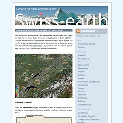
Elle s’appelle Air Traffic et permet de visualiser le trafic aérien civil sur la Suisse en temps réel dans l’interface Google Maps. Les données sont récupérées à partir des transpondeurs dont tous les avions sont équipés. Gmapsmania - 100 Things to do with Google Maps Mashups. Sites linking to this page: Digg, C|Net News.com, StumbleUpon, MentalFloss, Corriere (Italy), Del.icio.us/Popular, Korben, SiliconValley.com, Geek News Central, LifeHacker, Bildirgec, NRK (Norway) [ Back to Google Maps Mania.. ] 1. Find a world brewery2. Track world terrorism3. Find a WiFi Hotspot in the US4. Tous les vols sur Google Map. J'avais rédigé un billet sur la géolocalisation des navires et leur représentation dynamique sur une mappemonde. Voici le même type de représentation mais pour la navigation aérienne. Libhomeradar - easy collect aircraft information - libhomeradar - easy collect aircraft information. Bienvenue sur le site de l'Ecole Française d'Extrème Orient.
Geolocalisation des navires equipes de la balise AIS par GoogleMaps. Impressionnant mashup de visualisation et géolocalisation des navires de commerce voguant sur toutes les mers du globe. Le terme mashup est presque réducteur, mieux vaudrait parler de base de données avec mise à jour permanente. Cette base est le fruit d'un projet communautaire. Aerial Virtual tour of New York. Des Images inédites du 11 septembre. Un procès pour avoir accès aux images 9 ans après les attentats voici des vidéos inédites obtenues par une ONG baptisée : « The International Center for 9/11 Studies« . Une organisation dont les responsables mettent en doute la version officielle et financent des recherches sur les attentats du 11 septembre 2001. Ils ont ainsi participé à la rédaction d’un document de 26 pages de questions sur le rapport d’enquête consacré à l’effondrement du Batiment 7 du World Trade Center.
Pour avoir accès aux archives audiovisuelles du 11/09 cette ONG a lancé une action en justice au nom de la loi sur la liberté d’information (Freedom of infirmation act). La procédure visait l’agence gouvernementale qui centralise les vidéos, les photos produites le 11 septembre : le NIST (National Institute of Standards and Technology) dont la mission a été d’enquêter sur l’effondrement des tours jumelles du World Trade Center et du bâtiment 7. 1* Les images et la bande son. 2* Des cris. Superposer une carte ancienne et Google Earth. Geologist connects regular changes of Earth's orbital cycle to changes in climate. In an analysis of the past 1.2 million years, UC Santa Barbara geologist Lorraine Lisiecki discovered a pattern that connects the regular changes of Earth's orbital cycle to changes in Earth's climate. The finding is reported in the scientific journal Nature Geoscience. Lisiecki performed her analysis of climate by examining ocean sediment cores.
These cores come from 57 locations around the world. By analyzing sediments, scientists are able to chart Earth's climate for millions of years in the past. Lisiecki's contribution is the linking of the climate record to the history of Earth's orbit. Maporama.com - Cartes, Plans d'acces et itineraires partout dans le monde. Newsmap. Cartes-Atlas-Plans de villes. Paris - Paris France. Cliquez sur la carte ou sur le numéro de l'arrondissement dans les cases ci-dessous. Click the district on the map or on its number below Cartes Google des arrondissements.
NizhnyNovgorod.