
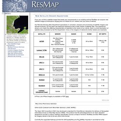
Mercator Ocean. ResMap. If you can not find a satellite image that meets your requirements in our existing archive ResMap can acquire new satellite images at resolutions ranging from 30 metres to 0.61 metres over your area of interest.
Our Remote Sensing (RS) Department specializes in correction, analysis and processing of satellite imagery and derived products. Our RS team has extensive experience with a wide variety of satellite data. This experience allows us to match the differing characteristics of satellites to the needs of our clients. Global Land Cover Facility. Astrium GeoInformation Services. Global Mapping solutions.