
Plate Tectonics w/ Google Earth - Ashford School Technology Lesson Plans. Students will use hands-on learning to better understand what tectonic plates are, how they move, and what their movements cause.
They will do so mostly by interacting with Google Earth. Through teacher-guided discussions and activities and student explorations, students will have the opportunity to learn how to navigate in Google Earth to see landscape features of the Earth and to focus on earthquakes and volcanoes to realize that they form due to the movements of tectonic plates. Description: A. Show pictures/diagrams of cross-sections of tectonic plates on SmartBoard using Internet sites or SmartBoard technology B. -Zoom in to better see oceanic crust and continental crust of tectonic plates -Show mid-ocean ridges, but do not tell students what they are yet -Show areas where oceanic and continental crust meet-Ask students why does it look like there are “lines” (1) on ocean floor (where mid-ocean ridge is) and (2) where oceanic crust and continental crust meet?
Plate Tectonics. Lesson Summary Overview According to the theory of plate tectonics, Earth's crust is composed of a number of individual plates that change shape and position over time.
Geophysical evidence indicates that the face of Earth's surface has changed significantly since its initial formation and that the plates on which the continents are located are in constant motion. The movement of the plates is responsible for the formation of ocean basins, mountain ranges, islands, volcanoes, and earthquakes. Important concepts in the theory of plate tectonics include the following: The ocean floors are continually moving — spreading from the center, sinking at the edges, and being regenerated.Convection currents beneath the plates are responsible for plate movement.The source of energy responsible for generating the heat and convection currents that move the plates is most likely radioactivity deep in Earth's mantle.
Objectives Grade Level: 6-8 Suggested Time Two class periods Multimedia Resources Materials.
7-4. Geographylessonplans.wikispaces. This lesson plan is based on Florida State StandardsSC.6.E.6.2: Recognize that there are a variety of different landforms on Earth’s surface such as coastlines, dunes, rivers, mountains, glaciers, deltas, and lakes and relate these landforms as they apply to Florida.
SC.6.E.6.1: Describe and give examples of ways in which Earth’s surface is built up and torn down by physical and chemical weathering, erosion, and deposition. This is a week long lesson plan incorporating all seven levels of blooms taxonomy and should be useful for educators of 6th-7th grade science classes. Enjoy :) Lesson plan based on the ASSURE model Analysis of learners Classroom of 20 students, 10 male, 10 female. Objectives Students will use the information lectured on in class and found online to accomplish a different activity each day pertaining to land formations and physical and chemical weathering. Free Powerpoints - Rivers of the World. Landforms - World Geography - Free Presentations in PowerPoint format, Interactive Games & Activities. Chapter_14%20%20River%20Systems%20and%20Landforms. Biosphere: Erosion. Erosion is the process that breaks things down.
As far as we're concerned, erosion is the breakdown of the continents and the land around you. Investigate the Facts. 1.
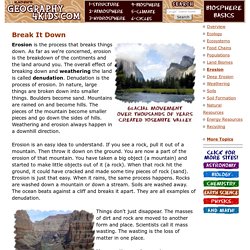
Investigate the Facts Erosion is happening all around us. Even though you may not recognize it, the forces of erosion are constantly shaping our planet. How do glaciers affect land? Glacier National Park, in Montana, U.S.A., also shows a variety of glaciated valleys.
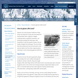
Here, part of the mountain has been cut away by a glacier. —U.S. Air Force collection/NSIDC Glaciers not only transport material as they move, but they also sculpt and carve away the land beneath them. A glacier's weight, combined with its gradual movement, can drastically reshape the landscape. Glacial Erosion Common all over the world, glaciated valleys are probably the most readily visible glacial landform.
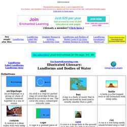
Fjords, such as those in Norway, are long, narrow coastal valleys that were originally carved out by glaciers. The Matterhorn in Switzerland was carved away by glacial erosion. The famous Matterhorn in Switzerland displays three types of glacial erosion: Cirques are created when glaciers erode backwards, into the mountainside, creating rounded hollows shaped like a shallow bowls. Glacial Landforms An eroded moraine juts above the landscape in the Rhone Valley, Switzerland. Landforms on Topographic Maps. Google Groups. Landforms Glossary. Advertisement.
EnchantedLearning.com is a user-supported site. As a bonus, site members have access to a banner-ad-free version of the site, with print-friendly pages.Click here to learn more. (Already a member? Click here.) Definitions: Plateaus, Plateaus Information. Plateaus are sculpted by geologic forces that lift them up and the wind and rain that wear them down into mesas, buttes, and canyons.
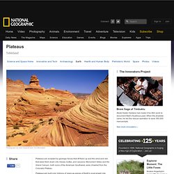
Monument Valley and the Grand Canyon, both icons of the American Southwest, were chiseled from the Colorado Plateau. Plateaus are built over millions of years as pieces of Earth's crust smash into each other, melt, and gurgle back toward the surface. Some owe their creation to a single process; others have been subjected to more than one during different epochs of Earth's history. The highest and biggest plateau on Earth, the Tibetan Plateau in East Asia, resulted from a collision between two tectonic plates about 55 million years ago.