
Nordmap. How to Read a Pilot’s Map of the Sky – Phenomena: All Over the Map. The first time I saw an aeronautical chart, best I can recall, was at the little airport café in Half Moon Bay, California, while waiting for a table.
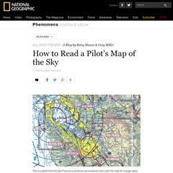
The coastal mountains and cities scattered around San Francisco Bay were easily recognizable. But superimposed on that familiar landscape were cryptic numbers, strange symbols, and overlapping circles that hinted at an entirely different world in the skies above. “It looks pretty complicated, doesn’t it?” Says Brendan Quinn-Narkin, a commercial pilot and certified flight instructor in Northern California. Students Can Compare Maps Side-by-Side in GE Teach. GE Teach is a great map tool that I last featured about 18 months ago.
GE Teach is developed and maintained by a high school teacher in Texas named Josh Williams. We had the chance to meet at TCEA this week and chat about GE Teach. A Good Tool for Creating Animated Maps. Maps) Tools - eTwinning PDW Warsaw - October 2015. Create Custom Map. 20 Good Map Creation Tools for Students. Pikakartta.
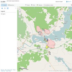
Google Earth esittely on Vimeo. World Geography Games - Let's play and learn about the world. Geography World. OpenStreetMap. Tietoa Euroopan unionista. Oppimispelit: Euroopan maantiede. Oppimispelit: Euroopan maantiede. Paikkatieto-ohjelmistot. Virtuaalikunta.net. Free maps, free blank maps, free outline maps, free base maps. ArcGis: esimerkki Vammala. ArcGIS Vammalan kaupunkirakenne Sign In ●Details ●Basemap ●Print ●Measure Toimintojen sijoittuminen Vammalassa Web Map by timo.niemimaaLast Modified: April 17, 2014 (0 ratings, 0 comments, 218 views) Map data © OpenStreetMap contributors, CC-BY-SA | Zoom to.
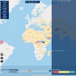
Tripline. Mercator Puzzle! The Monthly Conflict Situation Report. PrevNext September 2015 Mouse over a country for an update Click on a country for more Conflict Risk Alert: Conflict Resolution Opportunity:
40 Maps That Explain The Middle East. Maps can be a powerful tool for understanding the world, particularly the Middle East, a place in many ways shaped by changing political borders and demographics.
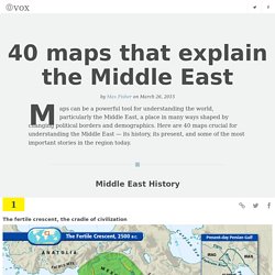
Here are 40 maps crucial for understanding the Middle East — its history, its present, and some of the most important stories in the region today. Middle East History The fertile crescent, the cradle of civilization The fertile crescent, the cradle of civilizationIf this area wasn't the birthplace of human civilization, it was at least a birthplace of human civilization. Watch as 1000 years of European borders change.
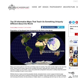
Earth wind map. Mistä nyt tuulee? Loistava interaktiivinen kartta maailman tuulista. Ote Cameron Beccarion kehittämästä kartasta.
Tuulet ovat kauniita ja ikuisia. Se tulee ensimmäisenä mieleen, kun katselee Cameron Beccarion kehittämää maailman tuulien visualisointia. Se päivittyy kolmen tunnin välein. Tiedoista vastaa Yhdysvaltain GSF-malli, maailmanlaajuinen sääennustusmalli, jota Suomessakin käytetään ennusteiden yhtenä perustana. Supertietokoneet laskevat näitä ennustuksia. World Geography Games - Let's play and learn about the world. Geography Games - Educational Games Depot. Geography: Cities of the World Geography map games. Maailman valtioiden nimet suomeksi. Karttapelejä. Galerie Google Maps. PaikkaOppi - PaikkaOppi.
Etusivu - Paikkatietoikkuna. Geokätköilyn alkeet. You Don't Know Africa. GeoGuessr - Let's explore the world! Flightradar24.com - Live flight tracker! In order to save data consumption Flightradar24 web page times out after 30 minutes.
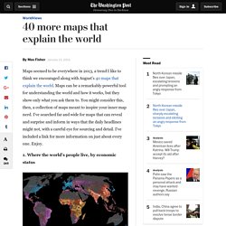
Please reload the web page to get another 30 minutes. Live Ships Map. Live From Space. Pikakartta. 42 Amazing Maps. Top 25 Informative Maps That You'll Never Forget. Population of Southeast Asia Compared to the Rest of the World Maps can be great guides for more than just finding routes for traveling.
They often provide insight on the rest of the world. Taking a look at certain maps can be incredibly informative, especially when comparing the standing of countries in relation to one another. In fact, many passionate cartographers take pride in creating maps that present relevant knowledge through a visual medium. Whether they're on topics concerning population density, educational level, or even a gauge of internet usage across the world, each serves a purpose of sharing data to enlighten minds. An ever-growing collection of informative maps are available through ChartsBin, Target Map, and the MapPorn subreddit. 40 more maps that explain the world. Maps seemed to be everywhere in 2013, a trend I like to think we encouraged along with August's 40 maps that explain the world.
Maps can be a remarkably powerful tool for understanding the world and how it works, but they show only what you ask them to. You might consider this, then, a collection of maps meant to inspire your inner map nerd. I've searched far and wide for maps that can reveal and surprise and inform in ways that the daily headlines might not, with a careful eye for sourcing and detail. I've included a link for more information on just about every one. 36 maps that will make you see the world in completely new ways. The internet has led to a renaissance in mapmaking, with thousands of interactive, illustrated, informational, or just plain silly maps being published on a daily basis.
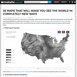
We’ve done a number of other pieces on some of the web’s interesting and weird maps, but there’s thousands more out there, and it can be hard to keep up. So here’s another installment, with 36 new maps we haven’t posted before. 1. Wind map of America Check out the live map of America’s winds at Hint.fm. 2. These are the lands Europeans actually first discovered — as in there weren’t already millions of people there. 3.
This map was fairly surprising to me — I certainly wouldn’t have guessed that Russia was more tolerant than France, and I’m happy to see the US is in the most tolerant group. 4. You know, with the exception of the giant swaths of Bud Light states, I’m not too ashamed of this map. 40 maps that explain the world. Part two: 40 more maps that explain the world Maps can be a remarkably powerful tool for understanding the world and how it works, but they show only what you ask them to. So when we saw a post sweeping the Web titled "40 maps they didn't teach you in school," one of which happens to be a WorldViews original, I thought we might be able to contribute our own collection.
Some of these are pretty nerdy, but I think they're no less fascinating and easily understandable. A majority are original to this blog (see our full maps coverage here), with others from a variety of sources. I've included a link for further reading on close to every one. 1. Click to enlarge. What's more amazing: how much things have changed over the last 1,800 years, a major chunk of the civilizational history of humanity, or how many of this map's divisions are still with us today? 2. Click to enlarge. This might be useful in planning your next vacation, although there are some big surprises in the results. 3. 4.