
Dive Site. Wrecks Pembrokeshire Wrecks Richard Hughes has compiled an excellent resource of Pembrokeshire's wrecks, providing the most up to date GPS locations.
The information is available in spreadsheet and pdf formats below: Pembs Wrecks (xls format) Pembs Wrecks (pdf format) If you have any suggestions of other sites, or corrections to this edition, please contact Rich via email at sharpswitch@yahoo.co.uk Dakotian N51 42 197. A British steamer sunk in 1940 by a German parachuted mine in the Haven in 1940 - see John Liddiard's wreck tour. Dan Beard N51 42.456. Under the cliffs of Pwll Deri, the wreck of a Liberty ship fropm the Second World War Behar N51 42.513. Another Haven wreck - read John Liddiard's wreck tour for more details. Guanito / Barbara N51 39 928. Just to the west of Freshwater West, known locally as the GB wreck because it is located beneath a cliff-side gorse bush in the shape of Great Britain, what was thought to be one wreck turned out to be two - the Gunaito and the Barbara.
Reefs.
Ships Photographs Collection. Strumblehead. Sound Metrics - ARIS Explorer 1800. DIDSON. Nautical Archaeology Society. Deep sea oceanographers from the UK’s National Oceanography Centre (NOC) in Southampton have produced a detailed report on the archaeological remains of the lost medieval town of Dunwich – dubbed Britain’s ‘Atlantis’.
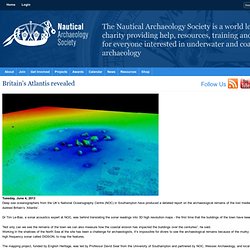
Dr Tim Le-Bas, a sonar acoustics expert at NOC, was behind translating the sonar readings into 3D high resolution maps - the first time that the buildings of the town have been seen in 750 years. “Not only can we see the remains of the town we can also measure how the coastal erosion has impacted the buildings over the centuries”, he said.Working in the shallows of the North Sea at the site has been a challenge for archaeologists, it’s impossible for divers to see the archaeological remains because of the murky waters, hence the need for high frequency sonar called DIDSON, to map the features.
The project to survey the site began in 2008 and it has since developed in to the world’s largest submerged medieval town site. More information from www.dunwich.org.uk. Nautical Archaeology Society. Following a successful pilot scheme in 2005 the NAS ran WreckMap Britain 2006 with the support of Seasearch, Crown Estate, PADI Project Aware and the British Sub-Aqua Jubilee Trust.
The project aims to get UK divers to collect and report basic archaeological and biological information about a wreck site that they dive on Who can participate? We hope to encourage as many of the 100,000 active divers in the UK as possible to participate as a part of their normal diving activities - just take a recording slate with you when you do a planned dive on a wreck site, record what you see and then report it back to us. Above: Photograph of a diver conducting an underwater survey, by Alison Fuller-Shapcott, one of this years winning survey entries. What can be recorded? Divers are also encouraged to use whatever photographic or video equipment they had available to make additional records to accompany your observations.
How can the data be reported? What will happen to the data? Efforts rewarded? WMB Form. Welcome to the Nautical Archaeology Society website.