
GNSS Planning Mobile. AndroiTS GPS Test Free. All the features of GPS Test plus:-★ WAYPOINT NAVIGATION★ HEAD UP DISPLAY★ DIGITAL FONTS (Great in the car) Now shows symbols for GLONASS satellites The GPS Test Plus app for Android is a utility that shows GPS information read from your phones internal GPS.
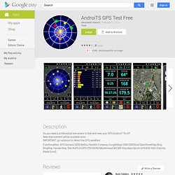
Will support GLONASS phones. The navigation functions can replace your 'Car Finder' app and also be used for Geocaching. It records the last twelve saved locations, so you can navigate a simple route as well. Maps. Explorer votre monde est plus simple et rapide que jamais grâce à Google Maps.
Maps Engine. GPS Test. The GPS Test app for Android is a utility that shows GPS information read from your phones internal GPS.
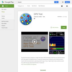
Will support GLONASS phones. The app has several colour schemes, which could be used to match other instrumentation, used along side the app. It has a "night mode" colour scheme as well. Total Station Survey. 574 Calculators & Converters related to Civil, Beams, Columns, Piling, Concrete, Survey, Soil & Earthwork, Structural Engineering, Bridges, Highway & Road, Hydraulics and Timber.
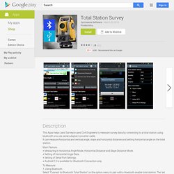
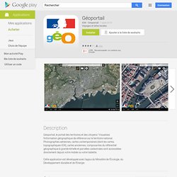
Civil Engineering Pack contains 574 Calculators and Converters, that can quickly and easily calculate and convert different Civil Engineering parameters. Automatic & Accurate Calculations and Conversions with every Unit and Value Changes. Available in Imperial and Metric Units. Most Comprehensive Civil Engineering and Construction Calculator. Géoportail. Application de navigation tout-terrain avec des cartes topographiques du monde entier (essentiellement des armées russes).
EDUGEO. Maverick: GPS Navigation. BIG EASTER SALE -50% on Europe, World, Brasil or North America!
LA APLICACIÓN DE NAVEGACIÓN SIN CONEXIÓN CON MÁS DESCARGAS DEL MUNDO Sygic es una aplicación de navegación GPS giro a giro que puede probar totalmente gratis. Leica DISTO™ sketch. *** This Old House TOP 100 Best New Home Products: "a superpower for anyone shopping for furnishings to fit a space" *** ImageMeter lets you measure dimensions, angles and areas in your images with ease.
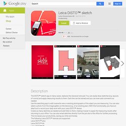
No more need to draw a sketch of your new apartment in order to plan the new furniture. Simply take a photo and annotate it with the dimensions on your phone or pad. What is special about ImageMeter is that it enables you to measure within the image long after you took the picture. It often happens that after taking the photo, being back at home or in the office, one realizes that some important distances have not been measured. This is the free version with watermarks in exported images, some limitations on the number of measures per photo and limited Bluetooth measurement distance. Documentation is available online at: Support email: imagemeter@gmail.com. Trimble Outdoors Navigator. Backpacker’s GPS Trails Lite doubles as a portable trip database and personal navigation device for your outdoor lifestyle: hiking, backpacking, camping, mountaineering, or for just basic trail navigation.
GPS Trails Lite works in remote places like national parks, wilderness areas, and backcountry spots without relying on data and cell signals. -----UPGRADE TO PROTry the free app then upgrade to GPS Trails Pro for even more features, including: * Create map packs to store maps on your phone. This app allows you to save topos (MyTopo), aerials (Bing), streets (OSM), and terrain (OCM) map types. * Get worldwide aerial images on your phone. Our app gives you rare access to view and store offine aerial imagery from Bing maps. * Shoot video and geotag it to an exact location on a map. ZWCAD Touch. CAD Pockets (anteriormente ZWCAD Touch) es una potente aplicación CAD móvil hecha a medida para diseñadores, arquitectos e ingenieros.
Soporta varios formatos de archivo que abarcan desde DWG, DXF, a DWF. Puede abrir archivos instantáneamente sin ningún retraso, independientemente de su tamaño. Aparte de ver los dibujos, puede también revisar, anotar y exportar archivos a PDF o DWF así como compartir el archivo con sus colaboradores vía email. AutoCAD 360. CAD Touch is a professional CAD solution that completely reinvents on-site drawing, giving to professionals in various core fields like architecture, engineering, real estate, home design, and more, the power to measure, draw and view their work on-site. CAD Touch is really easy to use and it's fast multitouch interface will give you the precision and flexibility that pen and paper fail to archive, finally you will have the perfect on-the-go companion for desktop software like AutoCAD™, SketchUp™ or Solidworks™ and every other DWG/DXF compatible app.
Complete support for decimal and imperial measure units (architectural feet and inches). CAD Touch requires no internet connection, no subscription. Floor Plan Creator. Create detailed and precise floor plans.
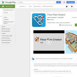
See them in 3D. Add furniture to design interior of your home. Have your floor plan with you while shopping to check if there is enough room for a new furniture. MagicPlan. Créez des plans simplement avec la caméra de votre appareil mobile. Scannez une pièce en 30 secondes et complétez vos plans en quelques minutes. Un plan de niveau est le point de départ d’autres fonctionnalités telles que la réalisation de devis, de modèles 3D et de visites virtuelles. Session d’entraînement disponible en anglais sur magicplan est reconnue mondialement:• Téléchargée par plus de 18 millions d’utilisateurs• Chaque jour l’équivalent d’une petite ville est cartographié avec magicplan. Blumatica Rilievi mobile. MERCI DE LIRE--------------------------MagicPlan ne fonctionne que pour les appareils équipés d'un gyroscope, d'une caméra frontale et d'Android 4.x Certains fabricants affichent leurs appareils comme étant équipés d'un gyroscope, sans pour autant que cela soit le reflet de la réalité.
Nous vous invitons à tester si votre appareil à un vrai gyroscope en récupérant une application qui liste vos senseurs (par exemple: Si votre appareil rempli toutes les conditions, MagicPlan peut fonctionner. Cela ne signifie pas que MagicPlan est prêt à être utilisé, puisque votre appareil doit être calibré. Nous validons des appareils aussi rapidement que possible, et une procédure manuelle vous est proposé si votre appareil ne l'était pas. Si vous rencontrez des problèmes dès le départ, il est probable que votre appareil n'est pas calibré correctement, cela n'a probablement pas grand chose à voir avec MagicPlan.