
Incredible 3D Scans of Castles, Churches, and Even Mt. Rushmore. Nasa laser probe will map Earth's forests in 3D. Nasa is currently developing a laser-based probe for the International Space Station that will study Earth's forests in 3D.
The idea behind the 3D mapping is to fill in the missing information about the role the forests play in the carbon cycle. The instrument, called the Global Ecosystem Dynamics Investigation (GEDI) lidar, will be the first to systematically probe our forests from space and is scheduled to be completed in 2018. Researchers Use Drones and Lasers to Map Out Ancient Maya Sites. Here's a new way VR can make you sick; the first Oculus Rift surgery. Siggraph 2014: Displaced Dynamic Expression Regression for Real-time Facial Tracking and Animation. Image-editing technique lets 2D objects get flipped, turned upside-down. Sure, Photoshop and other image editors are becoming increasingly good at transforming elements of a photo, but most of those tweaks are limited to two dimensions (resizing, rotating, repositioning, etc.).
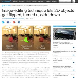
Researchers at Carnegie Mellon are pushing into the third dimension, using a technique that compares the 2D objects in a regular photo with 3D models freely available online. The result? An autonomous flying robot that avoids obstacles. An autonomous flying robot avoids a tree on the Cornell Arts Quad (credit: Saxena lab) Able to guide itself through forests, tunnels, or damaged buildings, an autonomous flying robot developed by Ashutosh Saxena, assistant professor of computer science at Cornell University, and his team could have tremendous value in search-and-rescue operations, according to the researchers.
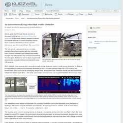
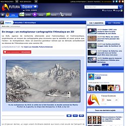
The test vehicle is a quadrotor, a commercially available flying machine table with four helicopter rotors. Human controllers can’t always react swiftly enough, and radio signals may not reach everywhere the robot goes. So Saxena and his team programmed quadrotors to navigate hallways and stairwells using 3-D cameras. But in the wild, these cameras aren’t accurate enough at large distances to plan a route around obstacles. En image : un motoplaneur cartographie l'Himalaya en 3D. Vu du motoplaneur du DLR, la vallée de la Kali Gandaki, le double sommet du Macha Puchar et, à gauche, le cirque des Annapurna. © DLR, cc by 3.0 En image : un motoplaneur cartographie l'Himalaya en 3D - 4 Photos.
ARGUS, le drone qui voit tout. Oubliez les petits satellites de surveillance, Big Brother vient d'ajouter une toute nouvelle corde à son arc, ARGUS !
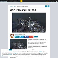
Ce drone de l'agence pour les projets de recherche avancée de défense américaine est équipé d'une caméra hors norme capable de tout voir ou presque, à une altitude de 20 000 pieds. « Autonomous Real-Time Ground Ubiquitous Surveillance Imaging System » (ARGUS) est un système d’imagerie en temps réel ultra-perfectionné. SenseFly drones generate an amazing 3D model of the Matterhorn. Take Instant Photospheres With This One-Shot Omnidirectional Camera. A robotic insect makes first controlled test flight. Robotic insect (credit: Harvard University) Harvard roboticists have created a robotic insect the size of a paper clip and successfully test-flown it.
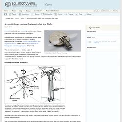
Inspired by the biology of a fly, the intricate design is the culmination of 12 years of painstaking work by researchers at the Harvard School of Engineering and Applied Sciences (SEAS) and the Wyss Institute for Biologically Inspired Engineering at Harvard. The device represents the cutting edge of micromanufacturing and control systems, says Robert J.
Wood, Charles River Professor of Engineering and Applied Sciences at SEAS, Wyss core faculty member, and principal investigator of the National Science Foundation-supported RoboBee project. Toute l'actualité des drones et du vol en immersion. Google investit 10.7 millions de dollars dans une société spécialisée dans les drones. Google ne pouvait pas rater l’envol des drones.
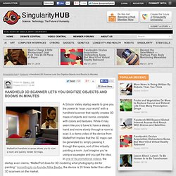
Watch the World's Smallest Flying Robot Insect Take to the Sky. Scalable KinectFusion. Home - ScanLAB Projects. Handheld 3D Scanner Lets You Digitize Objects And Rooms In Minutes. MatterPort handheld scanner allows you to scan a room and quickly render 3D maps.
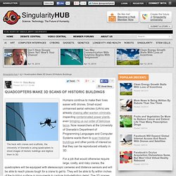
Quadcopters Make 3D Scans Of Historic Buildings. The heck with cranes and scaffolds, the University of Granada is using quadcopters to shoot images of historic buildings and digitize them to 3D.
Google gets the jump on better 3D maps with a “fleet of planes” At an event today in San Francisco, Google made a predicted announcement: 3D maps—not just little buildings drawn with perspective, but genuinely detailed 3D structures and topography—are coming to Google’s maps app.

After Google reminisced about how far it has come since purchasing maps startup Keyhole half a decade ago, the company introduced an offline maps feature that will surely please its more adventurous users. But Google could face real competition for the first time in half a decade, and some of what it announced today will be judged according to how well Google Maps will stand up to that. After all, millions of iPhone users may soon be giving their search data to Google’s “thermonuclear” antagonist, Apple. Arriving in the third dimension Peter Birch, product manager of Google Earth, introduced photorealistic 3D imagery in Google maps for both Android and iOS devices.
Still, the demo promised some very cool future applications. Ignoring a possible slight from Apple. Faceshift. Disney's New Algorithm Turns Any Photo Into a 3D Wonderland. Megastereo: Constructing High Resolution Stereo Panoramas. NIT wins the prestigious Vision Award for the 25th Anniversary of Vision Stuttgart. Presenting its new MAGIC 3D solution, NIT was chosen as the winner of the VISION Award 2012 by the jury. Since several years, the 3D and Stereoscopic vision have started aggressively their entrance in the industrial market and the machine vision industry.
SIGGRAPH 2013: Semantic Decomposition and Reconstruction of Residential Scenes from LiDAR Data. 3D Surface Reconstruction. Photogrammetry. Photogrammetry is an estimative scientific method that aims at recovering the exact positions and motion pathways of designated reference points located on any moving object, on its components and in the immediately adjacent environment. Photogrammetry employs high-speed imaging and the accurate methods of remote sensing in order to detect, measure and record complex 2-D and 3-D motion fields (see also SONAR, RADAR, LiDAR etc.).
Photogrammetry feeds the measurements from remote sensing and the results of imagery analysis into computational models in an attempt to successively estimate, with increasing accuracy, the actual, 3-D relative motions within the researched field. Its applications include satellite tracking of the relative positioning alterations in all Earth environments (e.g. tectonic motions etc), the research on the swimming of fish, of bird or insect flight, other relative motion processes (International Society for Photogrammetry and Remote Sensing). Matherix Labs. 3D Mesh Generation with KScan3D software and Kinect. HyTAQ Robot Goes from Air to Ground and Back in a Split-Second. Microsoft Reveals Multiplayer Gaming Extending to Mobile Devices. Microsoft's gaming engineers are always on the move with new ideas and in today's revelations you'll see how they're thinking of new ways of advancing multiplayer video games. Specifically, users at home will be able to use their base Xbox and Kinect systems to create some amazing 3D environments for video games that could then be shared friends at home, outdoors or on the road that only have a smartphone or tablet at their disposal.
If you're a lover of multiplayer games, then be assured that Microsoft's teams are hard at work with future advancements to enhance your gaming experience. Microsoft's Patent Background Computer gameplay is now widely available for a number of different computing devices. For example, computer games have been developed for home systems and portable systems such as tablets, mobile phones, and other devices.
New Naval app secretly recreates environments from your phone. The Naval Warfare Surface Center in Crane, Indiana today revealed a smartphone app that puts the capability of modern smartphones to observe areas in sharp relief and shows the power of malware to tap into those capabilities. The app, PlaceRaider, is capable of running in the background of any smartphone running Android 2.3. While running in the background, it takes photos at random while recording the orientation and location of the phone. Microsoft KinEtre lets you possess people, inanimate objects.
Video-Based 3D Motion Capture Through Biped Control. Matterport. Matterport. Floored Generates Customizable 3D Models For Real Estate Using Kinect-Like Sensors. Recréer de la 3D à partir d’une photo 2D. La 3D est sur toutes les lèvres. Cinéma, photo, vidéo, consoles de jeux vidéo, ordinateurs… C’est la tendance du moment. Récréer un environnement en 3D à partir de photographie est possible, mais long et fastidieux.
Des Japonais ont mis au point un moyen simple et rapide. Nouveautés Google Maps: full 3D, hors connexion et sac à dos Google Street. CORDIS Wire. Des scientifiques de l'Université de Grenade ont mis au point un système permettant de scanner des modèles 3D d'édifices historiques moyennant des Véhicules aériens sans pilote (UAV en anglais), des aéronefs capables de se déplacer sans équipage ni pilote. Ce projet unifie pour la première fois trois technologies déjà employées actuellement : les dispositifs UAVs, les techniques de reconstruction 3D à partir de photographies et la représentation virtuelle de modèles afin de fournir une reconstruction fiable de modèles architectoniques à un coût peu élevé.
Publiez et partagez du contenu 3D interactif sur Sketchfab.