
Villains Wiki - villains, bad guys, comic books, anime. Paleofuture - Paleofuture Blog. Medieval Weapons. Crossbows A crossbow is a range weapon that shoots projectiles (called bolts or quarrels) consisting of a bow mounted on a stock.
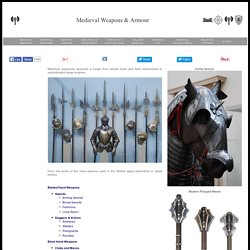
The medieval crossbow was called by many names, most of which derived from the word ballista, a Roman torsion engine resembling a crossbow in appearance. Historically, crossbows played a significant role in the warfare of Europe, and the Mediterranean. A crossbow is a bow mounted on a stock (or tiller) with a mechanism that holds the drawn bow string. Early designs featured a slot in the stock, into which the cocked string was placed. A later design implemented a rolling cylindrical pawl called a 'nut' to retain the cocked string.
History page. The History of Science and Technology from the Collections of The Franklin Institute Science Museum. Cryptozoology and Strange Beasties. Klub psychotroniky a UFO Svitavy. Záhady Litomyšle Na zámku v rohu druhé galerie se na renesanční omítce nachází pět písmen G.
Vypráví se, že kdo je rozluští najde ukrytý poklad. Pod zámkem v rostlé skále se nachází velké podzemí. Jeden ze vstupů se nachází u zdi zámku mezi kaplí a boční věží. Chodby spojují některá místa zámku a vedou pod jeho zdi a také je tam jedna chodba vedoucí mimo zámek. V jižním křídle se dlouhá léta nacházel tzv. očarovaný pokoj. Západně od Litomyšle se nachází tzv. Hrad Karle je místní záhadou, víme o něm pouze z historických pramenů. Za pozůstatky hradu bývají považovány některé konstrukce usedlosti č. p. 81 tzv. V minulosti se prý na místě našly základy až tří studen (podle jiných jedna z nich byla spíše věží) a podzemní chodba. Podle: zpráva M. (c) Klub psychotroniky a UFO Svitavy, 2009. Karle. Karle (německy Karlsbrunn[1]) je obec nacházející se v okrese Svitavy, kraj Pardubický, zhruba 8 km západně od Svitav; rozkládá se po obou stranách historické česko-moravské zemské hranice.
Ke dni 3. 7. 2006 zde žilo 398 obyvatel. Obec je součástí Mikroregionu Svitavsko. Části obce[editovat | editovat zdroj] zároveň katastrální území a ZSJ Karle - téměř celé katastrální území leží v Čechách, ale východní okraj zasahuje na MoravuOstrý Kámen - větší východní část katastru, německy označovaná jako Mährisch Rausenstein leží na Moravě, menší západní část katastru, německy označovaná jako Böhmisch Rausenstein, patřící původně do katastrálního území Karle, leží v Čechách. Historie[editovat | editovat zdroj] První písemná zmínka o obci pochází z roku 1336. Böhmisch und Mährisch Rausenstein bei Zwittau. Rausenstein bestand bis 1939 aus zwei selbständigen Gemeinden.
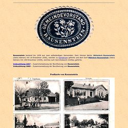
Dem kleinen Weiler Böhmisch Rausenstein (Ostrý Kámen) mit 19 Einwohner 1930), welcher zu Karlsbrunn gehörte und dem Dorf Mährisch Rausenstein (Ostrý Kámen) mit 148 Einwohner (1939), welches zum Gerichtsbezirk Zwittau gehörte. Volkszählung 1857 – Zusammensetzung der Bevölkerung von Rausenstein. Volkszählung 1869 – Zusammensetzung der Bevölkerung von Rausenstein. Postkarte von Rausenstein Auf dem Bild mit der Kapelle ist der Bauernhof Nr. 4 abgebildet.
Karle (hrad) O historii hradu máme velmi málo písemných pramenů.
V roce 1336 je uváděn Kunát z Karle, který snad na hradě sídlil. Jediná zmínka o hradě je ve švédské legendě o svaté Brigitě. V roce 1374 měl být pohřební průvod švédské královny napaden vojáky loupeživého rytíře z hradu Karle. Žádné další zprávy o hradu nejsou. Střepy nalezené na místě, kde hrad nejspíš stál, byly datovány do 14. století. Karlsbrunn bei Zwittau. Daß dieser Ort in alter Zeit Langendorf geheißen und erst, nachdem Kaiser Karl IV. einst sich an dem hiesiegen trefflichen Quellwasser gelabt, den Namen Karlsbrunn erhalten habe, ist zwar nur eine Sage, aber nicht unwahrscheinlich, wenigstens erscheint dieser Name schon 1547.
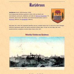
Karlsbrunn bei Zwittau Postkarte von Karlsbrunn 24.10.1899 Johann Gottfried Sommer schreibt in „Das Königreich Böhmen, Fünfter Band, Chrudimer Kreis, Prag in der J. G. Calve’schen Buchhandlung, 1837“ zur Pfarrkirche zu St. „Die Kirche (von Karlsbrunn, Anm. Gemeinde: Karlsbrunn, Bezirk: Leitomischl, Land: Böhmen Pfarrei: Karlsbrunn, Dekanat bzw Vikariat: Leitomischl, Diözese: Königgrätz Geburts.- Tauf und Sterbematriken ab 1695.
Die Matriken für den Ort befinden sich heute im Staatlichen Gebietsarchiv in Zámrsk. heute KARLE, Pfarre Karle Geburtsmatriken ab 1695 bis 1902 Heiratsmatriken ab 1695 bis 1913 Sterbematriken ab 1695 bis 1889. České paleontologické fórum. FOSÍLIE, ZKAMENĚLINY, OBCHOD, PRODEJ, TRILOBITI, PŘÍRODNINY - TORRIN. Detektory kovů - detektor web - detektory kovů! Virtuální prohlídka Národního muzea. The Fossil Forum. Tragédie Juříčkova mlýna v obci Leskovec. Index. Patrimonium-mundi.org : UNESCO World Heritage sites in panophotographies - immersive and interactive panoramic images. Wadi Hadramowt and walled city of Shibam.
Wadi Hadramowt and walled city of Shibam. The earliest reference to Shibam is that made in a pre-Islamic inscription of the third century A.D., as reported by Grohmann in his Encyclopedia of Islam.
According to the tenth (fourth) century historian al-Hamdani, Shibam became the capital of Hadramawt after the destruction of Shabwah, and it was to this town that the people of Shabwah fled, 'calling the place Shibam, which was originally called Shibat'. It is not known whether the town at that time stood precisely on the site of the present city, although the existence of the raised mound on which the walled city is built, rising more than 6 m above the surrounding flood plain, suggests the accumulation of ruins over a long period, On the other hand, this raised knoll has not been excavated by archaeologists, and it may yet be proved simply a natural outcrop of the mountain spur behind it.