
More Photoscan Experiments. I need to wrap up this subject soon.
But every time I visit a thread, I seem to open several others. This is about point and model reconstruction in Agisoft Photoscan. My Goal I want to be able to create realistic busts and maybe even poses of people, in full color, that I could 3d color print (via Shapeways, etc). (Here’s a professional company doing the same thing: Twinkind, $300, including visit to a studio.) Can you Measure Crush with an iPhone? — Lightpoint Data - Exemplar Vehicles for Crush Analysis.
On top of the graphical analysis above, the accuracy reports of both models were compared to one another.

In Photomodeler, the D3100 project RMS error was 0.34 pixels with a maximum of 0.79 pixels, while the iPhone RMS was 0.58 pixels with a maximum of 2.56 pixels. OpenMVG: "open Multiple View Geometry" MorphoSource. Abstracts of Presentations. DMS - Dimensional Metrology Services - Industrial Measurement Experts. LAIandFPAR_Validation_For_AusCover_Greenbook_v13.docx. AusCover Good Practice Guidelines (A technical handbook supporting calibration and validation activities of remotely sensed data products) Authors, version, date Copyright Goddard Building (Bld #8) The University of Queensland St Lucia, QLD 4072, Australia EMAIL: tern@uq.edu.au.
Open Source Photogrammetry: Ditching 123D Catch – We Did Stuff. Donate and Download. Please consider donating to Palentier.

We have worked hard on this software and believe it provides a unique tool for the UAV/UAS community. Markaeology. 360° Image Revolution – Blog. Vector Overlays on Panoramas [Orbit Knowledge Base] An overlay is a Dataset that is displayed in / on the panorama.
![Vector Overlays on Panoramas [Orbit Knowledge Base]](http://cdn.pearltrees.com/s/pic/th/overlays-panoramas-knowledge-83089054)
Orbit can overlay any supported vector resource. Overlaying Image resources is not supported. Kolor Labs: Measurement using Panoramas by Alexandre Jenny. Friday 7 September 2012 The Kolor team has been experimenting and developing a new solution to estimate accurately lengths and surfaces in a room from two spherical panoramas.
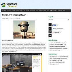
Digital photogrammetry. Imaging rover Archives - UPG. In October 2013 at Intergeo in Germany, Trimble announced their brand new V10 imaging Rover.
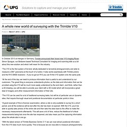
Trimble V10 Imaging Rover - Spatial Source. Positions From Pictures The Trimble® V10 Imaging Rover with Trimble VISION™ technology is an integrated camera system that precisely captures 360 degree digital panoramas for efficient visual documentation and measurement of the surrounding environment.
Either standalone or combined with a Trimble VX™ Spatial Station, S-Series Robotic Total Station, or Trimble R10 GNSS receiver, the Trimble V10 Imaging Rover provides the means to quickly capture rich data and create comprehensive deliverables. Together with Trimble Access™ field software on the Trimble Tablet Rugged PC and Trimble Business Center office software, the Trimble V10 is the complete geospatial solution. Rapid Data Capture – Trimble Vision at the rod The Trimble V10 featuring Trimble VISION technology allows you to capture a 60 MP panorama image with the simple push of a button. Capture everything now, measure later. The Next Disruptor: Changing the Business Landscape with Imaging Rovers.
Visualization and measurement are key components of geospatial data.
Imaging rovers reduce the cost of data acquisition while providing more information than ever before. The year 2013 witnessed the emergence of several important new technologies. Unmanned aerial systems (UAS) and new solutions for field imaging dominated industry headlines—and rightfully so. Dr Matt Nolan. 01 January 2014 Santa got me a UAV for Christmas.
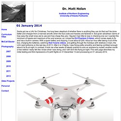
I've long been skeptical of whether there is anything they can do that can't be done better and cheaper from a manned aircraft, when the true costs and hassles are factored in. But given advertiser claims of how easy the small ones are to use and how cheap they are, I figured I had little to lose in checking one out. I wanted the minimum of hassle and maximum of fun and science, so I chose the DJI Phantom 2 Vision, which comes ready to fly and has a built-in camera. Underwater image preprocessing for automated photogrammetry in high turbidity water. The integration of photogrammetry, computer vision and image processing within well-known 3D reconstruction methods has enabled to make easier and quicker the generation of a 3D representation of real scenes.
In particular, photogrammetry has taken advantage of image feature detection; GPU computation and parallelized computation techniques to become more automatic and to raise input data size (e.g. thousands of photographs, several million of points). The integration of all these methods within photogrammetric survey has led to an increased complexity of the whole process. It is now difficult to evaluate a step of the process without taking in account previous or next steps. We distinguish two main approaches to photogrammetric systems: conventional systems compute the orientations of photographs and the 3D points from a set of calibrated camera and 2D observations (as points on the photographs).
The default camera in POV-Ray scene uses perspective projection. Solutionix > Photogrammetry. Home > Product > Photogrammetry It works together with Rexcan series, allowing users to import its obtained data into ezScan software. 3D scan with Rexcan series.
Terrageomatics.com. Photogrammetry is a computer based process that performs 3-D measurement from digital photographs. The Imagemaster software conducts 3-D measurements from stereo images – two images taken from different angles to the left and a right – of the object of measurement. The resulting model 3-D surface is accurate often on a sub-centimetre level which makes it ideal for fieldmapping. The example below was created using a stereo pair of images taken from a helium balloon. The resulting model was used to work out the volume of the stockpile read more. Terrageomatics.com.