
Natural Resources — CartoDB. Blog - Mapbox. Probe data is the byproduct of sensors and applications: hidden in logs, pings, and metadata lie tiny morsels of information like position and time.
Individually, every record has little meaning, but the aggregate can be extremely valuable for augmenting other datasets. We’re starting to use probe data as a cue for semi-automated improvements to OpenStreetMap. With algorithms that filter out noise and infer things like directionality and popularity of routes, we can identify roads missing from OpenStreetMap, turn restrictions, and even speed limits for Smart Directions. The data reveals complexity like time-based turn restrictions: you can’t turn left from Main St. onto Broadway between 4pm-6pm Monday through Friday. Introduction – JOSM. This page needs some more links to help pages.
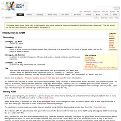
Also icons should be displayed instead of describing them. (Example: "The 8th button on the left (an icon with a wrench over a document)") Terminology ¶ [[Image(...)]] Node. JOSM/Photomapping. Available languages — JOSM Screenshot, showing photos arranged along a GPS trace Photomapping In JOSM allows you to work with photos on screen, positioned alongside the map data in the editor.
Obviously you can glean information from photos to add to the map without needing to be too clever, but if you have GPS location information included in to the photo files, or you have a separate GPS track, you can work use JOSM's photo mapping features to see them in context, and perhaps position new elements based on the recorded photo positions. Photos with stored locations JPEG photo files can have location information stored within them. On an iPhone be sure to have geotagging activated (Settings -> Privacy -> Location services -> Camera set to 'on') before taking the pictures with the normal iPhone photo app. Within JOSM you can simply open a photo file, or a directory full of photos using the 'File' menu 'Open' option.
Arranging photos on a GPS trace. Photo mapping. Available languages — For tracing aerial photos, see Aerial imagery.
Photo mapping, a popular mapping technique, can be a great timesaver - it can be far quicker taking photos of street signs or points of interest than either to write it down or fiddle with the GPS waypointing. What's more, since digital cameras add the date and time to each photo (in the EXIF data), and the GPS tracklog can be used to convert the time into your exact position, it's easy to match up the photos to the exact position they were taken. Simple photo mapping Use your camera to help you remember stuff. Documentation. API Reference This reference reflects Leaflet 0.7.
Docs for 0.6 are available in the source form (see instructions for running docs). Map. Import Geotagged Photographs into ArcMap. By Mark Romero Esri Imagery Team You can easily import geotagged digital photographs into your map and integrate them directly into your existing geodatabase using the new GeoTagged Photos To Points tool available in ArcMap 10.1.
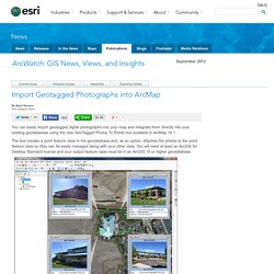
The tool creates a point feature class in the geodatabase and, as an option, attaches the photos to the point feature class so they can be easily managed along with your other data. You will need at least an ArcGIS for Desktop Standard license and your output feature class must be in an ArcGIS 10 or higher geodatabase. Import photos from your smartphone into ArcMap using the new GeoTagged Photos To Points tool. Here's how to use the tool to display geotagged photographs in ArcMap: Bentley Geospatial Management: Spatially Relating All Your Content in ProjectWise. ProjectWise Geospatial Management extends the ProjectWise environment with a geospatial view and gives geospatial context to any information.
Drawings, maps, models, images, vendor-specific GIS formats, and business documents in their originally intended form can all be related spatially in ProjectWise. This provides a practical and rapidly deployable system of organization, where the common denominator is spatial location. Everything at a particular location or area is readily available for you. Dynamic and interactive map-based interfaces allow users to intuitively navigate and retrieve content based on location. Integrated map management, dynamic coordinate system support, and practical spatial indexing tools provide the means to get up and running quickly and to routinely incorporate new content from your projects and operations. ProjectWise Geospatial Management provides many ways to search for information, including spatial- and property-based queries.
ExifTool by Phil Harvey. Read, Write and Edit Meta Information! Also available --> Utility to fix Nikon NEF images corrupted by Nikon software ExifTool is a platform-independent Perl library plus a command-line application for reading, writing and editing meta information in a wide variety of files. ExifTool supports many different metadata formats including EXIF, GPS, IPTC, XMP, JFIF, GeoTIFF, ICC Profile, Photoshop IRB, FlashPix, AFCP and ID3, as well as the maker notes of many digital cameras by Canon, Casio, DJI, FLIR, FujiFilm, GE, GoPro, HP, JVC/Victor, Kodak, Leaf, Minolta/Konica-Minolta, Motorola, Nikon, Nintendo, Olympus/Epson, Panasonic/Leica, Pentax/Asahi, Phase One, Reconyx, Ricoh, Samsung, Sanyo, Sigma/Foveon and Sony.
ExifTool is also available as a stand-alone Windows executable and a MacOS package: (Note that these versions contain the executable only, and do not include the HTML documentation or other files of the full distribution above.) The stand-alone Windows executable does not require Perl. GeoTag: An OS X Application to tag photo locations. GeoTag Version 3 GeoTag Version 3.3 Screenshot GeoTag is a free OS X application that allows you to update image metadata with geolocation tags by panning and zooming in a map window and then clicking on the location where a photo was taken.
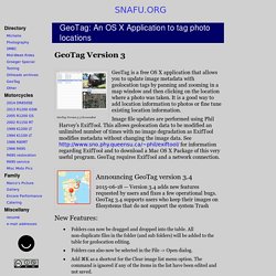
It is a good way to add location information to photos or fine tune existing location information. Image file updates are performed using Phil Harvey’s ExifTool. SfM-georef. Django 1.1 Talk Text - excess.org. Posted on 2009-05-16, last modified 2009-05-19.
This is the text from the Django 1.1 talk I gave on Friday May 15 at Algonquin College for FOSSLC's Geocamp/Summercamp 2009. I have tried to format this in a way that is well suited to skimming and easier to access from the web than reading the original slides. GeoDjango: Putting Django on the Map. SeaSketch. GeoDjango: Putting Django on the Map. SeaSketch. AN ENHANCED GIS PACKAGE FEAURING IMPROVED LIDAR TOOLS FROM BLOM. Blom has released v3.5 of its desktop geospatial application, BlomDESKTOP, including significant improvements to LiDAR functionalities.
Aimed at professional and academic GIS users, BlomDESKTOP Viewer offers advanced measurement and interrogation capabilities, in a standalone package. The latest release largely focuses on the addition of new LiDAR viewing and measurement features. Improved features include: New measurement tools for the LiDAR 2D profile view Customisable LiDAR colour modes based on classification, height, true colour and intensity Additional LiDAR viewer functionality, including point size and image export New GUI for 3D viewer and improved performance Increased proxy support – PAC (Proxy Auto Configuration) files now supported Range of improvements including improved language support. TileMill. DXF and GeoTIFF import. Application - QGIS Server Tutorial. About QGIS Server¶ The reference manual for QGIS Server is now available on the official manual: QGIS Server provides a web map service (WMS) using the same libraries as the Quantum GIS (QGIS) desktop application.Maps and print templates created in QGIS desktop can be published as web maps simply by copying the QGIS project file into the server directory.
The resulting web maps look exactly the same as in the desktop.QGIS Server is usually run as CGI/FastCGI module within the Apache Webserver. Core Features¶ Web Map Service (WMS) implementation Built-in PDF output WYSIWYG map creation with QGIS Advanced cartographic symbolisation Supports Styled Layer Descriptor (SLD) Identification of features and display of attribute data Webserver configuration¶ Debian/Ubuntu Linux¶ To setup QGIS Server with Apache 2 mod_fastcgi, the following packages are required: QGIS Server — OSGeo-Live 8.5 Documentation. QGIS Server provides web map and feature services (WMS & WFS) using the same libraries as the GIS (QGIS) desktop application. Maps and print templates created in QGIS desktop can be published as web maps simply by copying the QGIS project file into the server directory. The resulting web maps look exactly the same as in the desktop.
QGIS Server is usually run as CGI/FastCGI module within the Apache Webserver. Core Features. Publishing interactive web maps using QGIS. We all know that QGIS is great for designing maps but did you know that QGIS is also great for interactive web maps? It is! Just check out qgis2leaf and qgis2threejs. To give these two plugins a test run and learn some responsive web design, I developed a small concept page presenting cycle routes in 3D. Qgis2leaf makes it possible to generate Leaflet maps from QGIS layers. It provides access to different background maps and it’s easy to replace them in the final HTML file in case you need something more exotic. Quantum GIS (QGIS) - Landgate. The Event Visualization Tool (eVis) - Documentation. For use with QGIS version 1.2.0 This document was generated 2009-08-28 11:54:53.