
Cultural Heritage Imaging. We build innovative digital tools and practices that save world heritage.
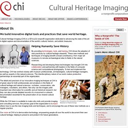
Cultural Heritage Imaging (CHI) is a 501(c)(3) nonprofit organization dedicated to advancing the state of the art in digital capture and documentation of the world’s cultural, historic, and artistic treasures. CHI Director Carla Schroer conducting a digital imaging training class Helping Humanity Save History By providing technologies, tools, and training, CHI drives the adoption of new practices by cultural heritage stewards. These new methods and techniques of imaging benefit a broad constituency, from major art museums to remote archaeological sites to fields in the natural sciences. Researching and developing these technologies has brought CHI into collaboration and partnership with leaders in the fields of computer science and computational photography. Fossils at the University of California Museum of Paleontology.
DStretch.com home page. Urban Archaeology: Electronic site registers: a way forward? The difficulties of using computer data-entry on site appear to be many and appear to be obvious: equipment costs, mud, rain, battery life, mud, rain, internet signal, IT support issues and the fact that you need to be able to do sketches on the back of the context sheet.
Several projects have however successfully used electronic data-loggers in adverse conditions, including all the human bone assessment data for the Spitalfields project which was inputted into hand-held dataloggers despite conditions of high humidity in the on-site processing area. With the increased use of digital cameras and GPS we are now used to looking after electronic equipment on site, and dealing with all the issues of rain, mud, damp and battery charging. Although context sheets may be with us for some years yet, there is one facet of site recording that can be very simply transferred to electronic data-logger: the site registers.
Blackfellows Hand. View map showing all Aboriginal Places Why is it an Aboriginal Place?
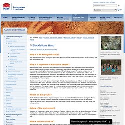
The Blackfellows Hand Aboriginal Place has Aboriginal rock shelters with painted art, a teaching site and occupation site. Why is it important to Aboriginal people? Blackfellows Hand Aboriginal Place was an important meeting and educational place and holds special meaning for Wiradjuri people. The place is also highly valued by the wider Aboriginal community, including Gandangara, Dharug and Dharkinjung people. Blackfellows Hand holds special meaning to Wiradjuri people because of their continuing cultural connection to the place. What's on the ground? Rock shelters and evidence of past camping can be found at Blackfellows Hand Aboriginal Place. Nature of the environment Situated on the western edge of the Newnes Plateau, the area lies within an amphitheatre of cliffs at the head of a tributary of the Coxs River. What's the land used for? Land status. Australia's newest innovative geospatial company!
Project Earth - CyArk. Everick Heritage Consultants. Everick Heritage Consultants is committed to working with you to secure workable, cost effective solutions to your heritage needs.
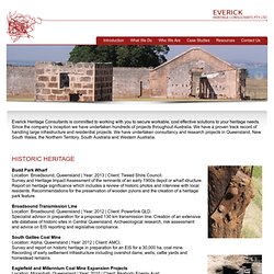
Since the company’s inception we have undertaken hundreds of projects throughout Australia. We have a proven track record of handling large infrastructure and residential projects. We have undertaken consultancy and research projects in Queensland, New South Wales, the Northern Territory, South Australia and Western Australia. Budd Park Wharf Location: Broadsound, Queensland | Year: 2013 | Client: Tweed Shire Council. Heritage & Archaeological Services. Godden Mackay Logan is Australia’s only multi-disciplinary heritage consultancy firm, providing heritage advice, assessment and management for all types of heritage places.

Indigenous Heritage Godden Mackay Logan and Jo McDonald Cultural Heritage Management provide a comprehensive range of Indigenous cultural heritage services. Our collaborative initiative, GML + JMcDCHM, combines the resources, knowledge ... Apex Archaeology-About. PROTECT AUSTRALIAS SPIRIT NOW! What is rock art?
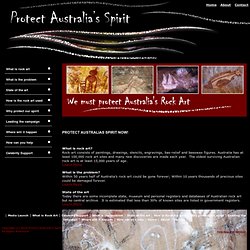
Rock art consists of paintings, drawings, stencils, engravings, bas-relief and beeswax figures. Australia has at least 100,000 rock art sites and many new discoveries are made each year. The oldest surviving Australian rock art is at least 15,000 years of age.Learn More What is the problem? Within 50 years half of Australia’s rock art could be gone forever; Within 10 years thousands of precious sites could be damaged forever.Learn More. Home. 3D GmbH: Home. Blue Mountains Virtual Video Tour. Index_en [DADP] Qgis_basic_01 [DADP] Markaeology: Determining Rock Art Deterioration Through Time: Automatic Change Detection with SfM Structure from Motion (SfM) is a very useful tool for creating 3D models from unreferenced images.
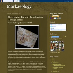
Since SfM can create highly detailed models from historic film and digital photographs, it is particularly helpful in examining changes in an object over time. In this short post I'll show how data collected at a pictograph site in 2003 can be compared with more recent data to pinpoint areas of deterioration in a systematic way. The pictograph we'll be looking at is located at 41CX2 and is part of a prehistoric site on the eastern edge of the Pecos River in West Texas. I like to use data collected from this site because there are no issues with making it publically available.
In order to compare a set of historic photographs with modern ones, aligning the two image sets to each other is critical. Australian Archaeological Association.