
New Zealand's White Island is likely to erupt violently again, but a new alert system could give hours of warning and save lives. Tourists visiting Whakaari/White Island on December 9 last year had no warning of its imminent violent eruption.
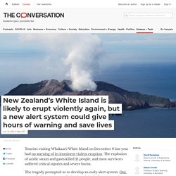
The explosion of acidic steam and gases killed 21 people, and most survivors suffered critical injuries and severe burns. The tragedy prompted us to develop an early alert system. Our research shows patterns of seismic activity before an eruption that make advance warning possible. Long read: reflections of a volcanologist as a science organisation faces charges in the wake of the 2019 Whakaari eruption. This week, a case review hearing sought to set a trial date – now likely in 2023 – for 13 organisations and individuals facing charges in the wake of the Whakaari White Island eruption of December 9 2019.
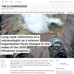
The volcano erupted while 47 people were on the island, leaving 22 dead and survivors with severe or critical injuries. Among the parties facing criminal charges is a research organisation that monitors volcanic activity on the island. For me, as a volcanologist, this highlights the perils of assessing hazards and communicating the risk of natural hazards. Read more: Whakaari tragedy: court case highlights just how complex it is to forecast a volcanic eruption A few years ago my wife and I visited an active and dangerous volcano.
Earthquakes / Natural Hazards and Risks / Our Science. Every year, thousands of earthquakes occur in New Zealand that are too small to be felt.
However, in the 15 years between 1992 and 2007, New Zealand experienced over 30 earthquakes of magnitude 6 or more. GNS Science is monitoring our earthquakes, large and small, and our active fault lines in order to understand past events, and prepare for the future. Research & Consultancy Expertise Road damage near Dee stream with failure of embankment fill. Inangahua earthquake, May 1968. Autonomous drones could speed up search and rescue after flash floods, hurricanes and other disasters. During hurricanes, flash flooding and other disasters, it can be extremely dangerous to send in first responders, even though people may badly need help.

Rescuers already use drones in some cases, but most require individual pilots who fly the unmanned aircraft by remote control. That limits how quickly rescuers can view an entire affected area, and it can delay aid from reaching victims. Autonomous drones could cover more ground faster, especially if they could identify people in need and notify rescue teams. My team and I at the University of Dayton Vision Lab have been designing these autonomous systems of the future to eventually help spot people who might be trapped by debris.
Satellites might soon be used to predict volcanic eruptions thanks to Whakaari/White Island. New Zealand scientists invent volcano warning system. New Zealand scientists say they have invented a warning system to predict volcanic eruptions that may prevent future tragedies such as the blast that killed 21 people on White Island/Whakaari in 2019.
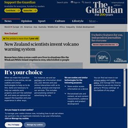
University of Auckland academics David Dempsey and Shane Cronin say their research “shows patterns of seismic activity before an eruption that make advance warning possible”. “Had our system been in place [on Whakaari last year] it would have raised the alert 16 hours before the volcano’s deadly eruption,” they said. The pair’s research has been published in Nature Communications this week. New Zealand is well served by a series of monitoring instruments, operated by GNS Science, which measure earth movements and tremors. The GeoNet system reports back data from the country’s thousands of earthquakes, and less frequent volcanic events, each year as they happen, but they are not predictive.
Social media could be key to warning people when the next earthquake hits. New Zealand is considering the implementation of an earthquake early warning system, but there may be a simpler, more affordable solution: social media.
Crowdsourcing information online, specifically through Twitter, might be a way for those affected to get quick, accurate and updated information in the event of an earthquake. Researchers from the European-Mediterranean Seismological Centre's (EMSC) new approach to earthquake warnings, called CsLoc (Crowdseeded Seismic Location), uses information readily available online to alert people of the location and strength of the earthquake. The Twitter Earthquake Detection (TED) system gathers "the public's search for information or their online reactions" through tweets fewer than seven words that contain the word 'earthquake' in one of 59 different languages. Compiling that with user's account geolocation and information the seismological centre has already received, people are provided with updated and relevant information.
Student profile: Nwadike Amarachukwu Nnadozie. A bit about me I was born in Owerri, the capital of Imo state which is located in the eastern part of a multi-cultural country in Africa called Nigeria.
I gained a bachelor’s degree in civil engineering (B.Eng) and my first master’s degree in structural engineering (first class honours), both from the Federal University of Technology Owerri, Nigeria. My desire to know more about disasters in the built environment and how I can contribute to reducing their impact propelled me to obtain my second master’s degree in Natural Hazards and Risks in Structural Engineering (NHRE) from Bauhaus University Weimar, Germany. I also have several years of working experience as a structural engineer, site engineer and research assistant. Earthquake and Tsunami. Fault Model Construction Project goal: Build an earthquake source model using known active faults from throughout New Zealand and nearby offshore areas.
We will test and refine earthquake sources using existing geological, seismological and GPS information, and use the source model to compute millions of synthetic earthquakes unique to New Zealand’s faults and tectonics.Project leads: Dr Bill Fry (GNS Science) and Prof Andy Nicol (University of Canterbury) Managing natural hazards LGNZ think piece. (39) RiskScape - Modelling the Impacts of Natural Disasters. New Zealand to have world-leading hazard risk modelling tool. EQC, GNS Science and NIWA have joined forces to further develop world-leading natural hazards risk modelling for New Zealand.
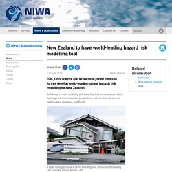
RiskScape is risk modelling software that lets users assess risk to buildings, infrastructure and people from natural hazards such as earthquakes, tsunamis and floods. RiskScape has been developed jointly by GNS Science and NIWA with the next general release due in mid-2020. The tool is based on open source technology, providing access for researchers and people working in disaster risk management to improve understanding of natural hazard risks in New Zealand and further afield. Sid Miller, EQC Chief Executive, said that EQC currently has its own tool to model damage and financial loss from earthquakes. ShakeMap. ShakeMap is a product of the USGS Earthquake Hazards Program in conjunction with the regional seismic networks.
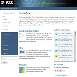
ShakeMaps provide near-real-time maps of ground motion and shaking intensity following significant earthquakes. These maps are used by federal, state, and local organizations, both public and private, for post-earthquake response and recovery, public and scientific information, as well as for preparedness exercises and disaster planning. ShakeMaps, Past 7 Days Real-time Feeds By Network (Past 30 Days) Introduction to the National Seismic Hazard Maps. What’s the difference between geologic hazard and risk?
Geologic hazards are naturally-occurring phenomena capable of causing loss or damage. Risk is the potential that exposure to the hazard will lead to a negative consequence such as loss of life or economic loss. To illustrate the difference, consider the following two examples.