
Global dimming. Global dimming is the gradual reduction in the amount of global direct irradiance at the Earth's surface that was observed for several decades after the start of systematic measurements in the 1950s.
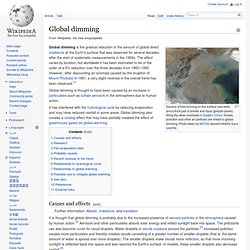
The effect varies by location, but worldwide it has been estimated to be of the order of a 4% reduction over the three decades from 1960–1990. However, after discounting an anomaly caused by the eruption of Mount Pinatubo in 1991, a very slight reversal in the overall trend has been observed.[1] Global dimming is thought to have been caused by an increase in particulates such as sulfate aerosols in the atmosphere due to human action. It has interfered with the hydrological cycle by reducing evaporation and may have reduced rainfall in some areas. Global dimming also creates a cooling effect that may have partially masked the effect of greenhouse gases on global warming.
Causes and effects[edit] Clouds intercept both heat from the sun and heat radiated from the Earth. Research[edit] The world's largest active archive of weather and climate data producing and supplying data and publications for the world. UK climate summaries. World climate data - Temperature, Weather and rainfall. Cambridge climate. Cambridge is 52 deg 12 North and 0 deg 07 East.
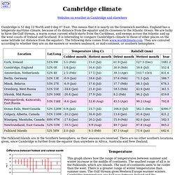
This means that it is nearly on the Greenwich meridian. England has a temperate maritime climate, because of its distance from the equator and its closeness to the Atlantic Ocean. We are lucky to have the Gulf Stream, a warm ocean current which starts from the Caribbean, and sweeps across the Atlantic and up the west coasts of Ireland and Scotland. It is interesting to compare Cambridge's climate to those of other places on the same latitude (or distance from the equator). The following data comes from www.worldclimate.com.
The Falkland Islands are in the Southern hemisphere, so their seasons are reversed. Temperature This graph shows how the range of temperatures between summer and winter increase in the middle of continents. Rainfall I have left out Ocean Falls from these rainfall graphs. Rainfall is more erratic than temperature, but the centre of continents seem to be drier than the edges. Return to index. National Climatic Data Center. The United States National Climatic Data Center (NCDC), previously known as the National Weather Records Center (NWRC), in Asheville, North Carolina is the world's largest active archive of weather data.
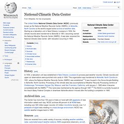
Starting as a tabulation unit in New Orleans, Louisiana in 1934, the climate records were transferred to Asheville in 1951, becoming named the National Weather Records Center (NWRC). It was later renamed the National Climatic Data Center, with relocation occurring in 1993. History[edit] In 1934, a tabulation unit was established in New Orleans, Louisiana to process past weather records. Climate records and upper air observations were punched onto cards in 1936. Archived data[edit] National Climatic Data Center, December 23, 1994 (GIBBS GOES-7 imagery) The Center has more than 150 years of data on hand with 224 gigabytes of new information added each day.
Sources[edit] Climate focus[edit] The NCDC states: Evidence is mounting that global climate is changing. Associated entities[edit] Data Sources. This page is a catalogue that will be kept up to date pointing to selected sources of code and data related to climate science.
Please keep us informed of any things we might have missed, or any updates to the links that are needed. Climate data (raw) GHCN v.2 (Global Historical Climate Network: weather station records from around the world, temperature and precipitation) USHCN US. Historical Climate Network (v.1 and v.2)World Monthly Surface Station Climatology UCAR Antarctic weather stations European weather stations (ECA) Italian Meterological Society IMS Satellite feeds (AMSU, SORCE (Solar irradiance), NASA A-train, Ocean Color) Tide Gauges (Proudman Oceanographic Lab) World Glacier Monitoring Service Argo float data International Comprehensive Ocean/Atmosphere Data Set (ICOADS) (Oceanic in situ observations) AERONET Aerosol information Arctic data from the Cooperative Arctic Data and Information Service (CADIS) Climate data (processed) Paleo-data.