
Footpath Maps: free online ordnance survey map and public footpath finder UK. #Alternate-Worlds on deviantART. TargetMap - Create & share customized data maps on Googlemaps. Free Online Mapping tool. Introducing The Map - A Proven Process For Developing Successful Online Communities. Here is a simple map for those of you whom aren't on the Pillar Summit mailing list.

The Map The map is based upon the online community lifecycle. Over the past few decades the lifecycle has been developed by academics, refined by practitioners and perfected by us. There are four stages to online community development. These are inception, establishment, maturity and mitosis (there is death too, but lets skip that for now). {click for larger image} Stage 1) Inception The inception stage of the online community lifecycle begins when the organization or individual begins interacting with their target audience and ends with the community achieving a critical mass of activity. The community reaches critical mass when more than 50% of growth and activity is being generated by members (as opposed to the community manager.)
The goal for the community manage at this stage is to provide the initial momentum and nurture the growth and activity until it has become self-sustaining. Mind42.com - Collaborative mind mapping in your browser. Antique Maps & Prints - Oxfordshire. Including a detailed old Town Plan of Oxford by John Speed c.1610 This fabulous old map print is crammed with detail and decoration including the arms of the Oxford colleges of the time and an incredibly detailed town plan of Oxford.
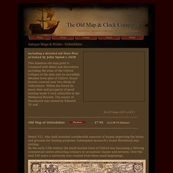
Royal forests covered over two-thirds of Oxfordshire. Within the forest its many deer and prospects of good hunting made it very attractive to the Mediaeval Royalty. The manor of Woodstock was owned by Edward 1V and . . 50 x 37.3cms (19.5" x 14.5") ___________________________________________________________________________________________ Henry V11, who both invested considerable amounts of money improving the house and grounds for hunting purposes. A fine old town plan of the City of Oxford features within the map . . . See Also Graduation Gift Idea. OpenStreetMap. Biggerplate - the mind map library. Mapping Flickr. Images are an important form of knowledge that allow us to develop understandings about our world.
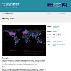
Flickr is the world’s most used and most popular public repository of photographs and currently hosts over five billion images. This map reveals the global geographic distribution of geotagged images on the platform, and thus reveals the density of visual representations and locally depicted knowledge of all places on our planet. Data Each point on the map indicates the total number of geotagged photographs uploaded to Flickr at that location. All geotagged photos were collected through Flickr’s application programming interface (API) using a custom designed program on April 1, 2011.
Findings As might be expected, the largest concentrations of photographs can be found in some of the world's most populated places. Visualization and analysis by Dr Mark Graham, Scott A. This map is taken from the following publication: "Graham, M., Hale, S. Old-Maps - the online repository of historic maps - maps page. Rare Antique Maps. Satirical Maps. An Incomplete Evolutionof the Cartoon Political Map 'Britannia' Etching by James Gillray; published in London by Hannah Humphrey in 1791 Image source: British Museum "A comic map of England formed by an old woman seated in profile to the left on the back of a dolphin-like monster, whose open mouth (right) represents the 'Thames', the two points of its tail being 'Lands End' and 'Lizard Point'.
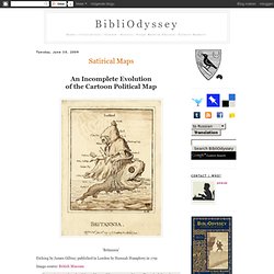
She holds a trident in her left hand. Wright & Evans, in their 1851 book, 'Historical and Descriptive Account of the Caricatures of James Gillray', describe 'Brittania' thus:"A rather ludicrous burlesque on the map of Great Britain, the work of some amateur artist, and etched by Gillray. " 'Geography Bewitched or, a Droll Caricature Map of Ireland' Designed by Robert Dighton; published in London by Bowles & Carver in 1793 Image source: British Museum 'Geography Bewitched or, a Droll Caricature Map of Scotland' Image source: Wikimedia 'Geography Bewitched or, a Droll Caricature Map of England and Wales'
Satirical Maps : un album.