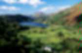
Welcome to the Yorkshire Dales National Park. Yorkshire Dales. The Yorkshire Dales (also known simply as The Dales) is an upland area of Northern England dissected by numerous valleys.

The area lies within the county boundaries of historic Yorkshire, though it spans the ceremonial counties of North Yorkshire and Cumbria. Most of the area falls within the Yorkshire Dales National Park, created in 1954 and now one of the fifteen National parks of Britain, but the term also includes areas to the east of the National Park, notably Nidderdale.[1] The Dales is a collection of river valleys and the hills among them, rising from the Vale of York westwards to the hilltops of the main Pennine watershed. In some places the area extends westwards across the watershed, but most of the valleys drain eastwards to the Vale of York, into the Ouse and then the Humber. Geography[edit] Most of the dales in the Yorkshire Dales are named after their river or stream (e.g., Arkengarthdale, formed by Arkle Beck).
Tourism[edit] Cave systems[edit] Gaping Gill. Loch Lomond. Loch Lomond (/ˈlɒxˈloʊmənd/; Scottish Gaelic Loch Laomainn) is a freshwater Scottish loch which crosses the Highland Boundary Fault.
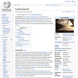
It is the largest inland stretch of water in Great Britain by surface area.[1] The loch contains many islands, including Inchmurrin, the largest fresh-water island in the British Isles.[2] Loch Lomond is a popular leisure destination and is featured in song. Geography[edit] Loch Lomond is a freshwater loch lying on the Highland Boundary Fault, often considered the boundary between the lowlands of Central Scotland and the Highlands. It is 39 kilometres (24 mi) long and between 1.21 kilometres (0.75 mi) and 8 kilometres (5.0 mi) wide. It has an average depth of about 37 metres (121 ft), and a maximum depth of about 190 metres (620 ft). Traditionally a boundary between Stirlingshire and Dunbartonshire, Loch Lomond is currently split between the council areas of Stirling, Argyll and Bute, and West Dunbartonshire. Islands[edit] English travel writer, H.V. Loch Lomond and The Trossachs National Park. Home. Snowdonia. Snowdonia (Welsh: Eryri) is a region in north Wales and a national park of 823 square miles (2,130 km2) in area.

It was the first to be designated of the three National Parks in Wales, in 1951. Name and extent[edit] The English name for the area derives from Snowdon, which is the highest mountain in Wales at 3,560 ft (1,085 m). In Welsh, the area is named Eryri. Lake District National Park - Home. Lake District. The Lake District, also commonly known as The Lakes or (particularly as an adjective) Lakeland, is a mountainous region in North West England.

A popular holiday destination, it is famous not only for its lakes, forests and mountains (or fells), but also for its associations with the early 19th century poetry and writings of William Wordsworth and the other Lake Poets. Historically shared by the counties of Cumberland, Westmorland and Lancashire, the Lake District now lies entirely within the modern county of Cumbria. All the land in England higher than three thousand feet above sea level lies within the National Park, including Scafell Pike, the highest mountain in England. It also contains the deepest and longest lakes in England, Wastwater and Windermere, respectively. Lake District National Park[edit] Lake District National Park (shown as number 2) in a map of National Parks in England and Wales. The lakes and mountains combine to form impressive scenery. Human geography[edit] Brecon Beacons. The Brecon Beacons (Welsh: Bannau Brycheiniog) is a mountain range in South Wales.
In a narrow sense, the name refers to the range of Old Red Sandstone peaks popular with walkers which lie to the south of Brecon. Sometimes referred to as "the central Beacons" they include South Wales' highest mountain, Pen y Fan. The range forms the central section of the Brecon Beacons National Park (Parc Cenedlaethol Bannau Brycheiniog), a designation which also encompasses ranges both to the east and the west of "the central Beacons". Home — Brecon Beacons National Park Authority.