
Geography of Vanuatu. Vanuatu. Vanuatu Islands Travel Guide. Vanuatu, the name of which means "Eternal Land", is one of the most unusual, exotic group of islands located in the south of the Pacific Ocean.
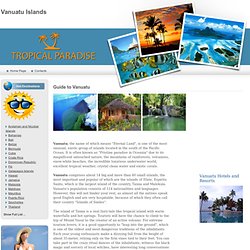
It is often known as "Pristine paradise in Oceania" due to its magnificent untouched nature, the mountains of rainforests, volcanoes, snow-white beaches, the incredible luxurious underwater world, excellent tropical weather, crystal clean water and exotic corals. Vanuatu comprises about 14 big and more than 60 small islands, the most important and popular of which are the islands of Efate, Espiritu Santo, which is the largest island of the country, Tanna and Malekula. Vanuatu. Vanuatu (English i/ˌvɑːnuːˈɑːtuː/ vah-noo-AH-too or /vænˈwɑːtuː/ van-WAH-too; Bislama IPA: [vanuaˈtu]), officially the Republic of Vanuatu (French: République de Vanuatu, Bislama: Ripablik blong Vanuatu), is an island nation located in the South Pacific Ocean.
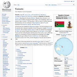
The archipelago, which is of volcanic origin, is some 1,750 kilometres (1,090 mi) east of northern Australia, 500 kilometres (310 mi) northeast of New Caledonia, west of Fiji, and southeast of the Solomon Islands, near New Guinea. The nation's name was derived from the word vanua ("land" or "home"),[7] which occurs in several Austronesian languages,[8] and the word tu ("stand").[9] Together the two words indicated the independent status of the new country.[9] History[edit] The prehistory of Vanuatu is obscure; archaeological evidence supports the commonly held theory that people speaking Austronesian languages first came to the islands some 4,000 years ago.