
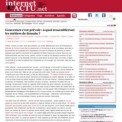
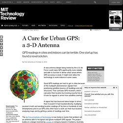
Future trends. Future trends. Five forces catapulting geography onto the world stage. Five converging global trends Five converging global trends may present geography with unprecedented world attention: geo-awareness, geo-enablement, geotechnologies, citizen science and storytelling.
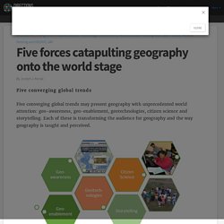
Each of these is transforming the audience for geography and the way geography is taught and perceived. Figure 1: Five converging global trends that present geography with new global opportunities. MRes Spatial Data Science & Visualisation. R Challenges for Students and Recent Graduates in GIS. As a recent graduate (2013) of GIS training at BCIT in Burnaby in addition to an Honours Bachelor of Science degree at UBC-Okanagan in Kelowna, I find that students and recent graduates can struggle with making the bridge between academia and industry to become established in their careers.
It’s certainly not a struggle unique to GIS and there are many factors involved, certainly one being location and demand for your particular skill set in the geographic region where you live. Having recently returned to Kelowna where the GIS job market is much slower than in the Lower Mainland, I recognize that continuing a GIS career is a challenge that really requires putting your name out for others to notice. The most difficult time for recent graduates in any given field is the first few years of working in their field. Certainly school systems are partly to blame for creating the academic focus and ladder mindset, particularly universities more than technical schools. Après les projets pharaoniques, la maquette numérique révolutionne la construction des bâtiments du quotidien. INSPIRE et Open Data, une complémentarité indispensable. Par Hervé Halbout, Consultant expert SIG et 3D (Halbout Consultants), avec la participation de Mathieu Becker, Président-fondateur d’Isogeo, vice-président de l’AFIGéo (pôle Entreprises-Industries) et Olivier Schwartz, Directeur marketing et communication d’Isogeo.
Dans les articles précédents de notre saga sur la gouvernance de l’information géographique, nous avions clairement énoncé que le catalogage des données géographiques était un prérequis essentiel à leur gestion. Redesigning Geospatial Education. By Anthony C.
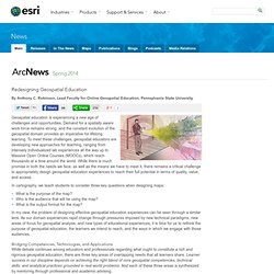
Robinson, Lead Faculty for Online Geospatial Education, Pennsylvania State University Geospatial education is experiencing a new age of challenges and opportunities. Demand for a spatially aware work force remains strong, and the constant evolution of the geospatial domain provides an imperative for lifelong learning. To meet these challenges, geospatial educators are developing new approaches for teaching, ranging from intensely individualized lab experiences all the way up to Massive Open Online Courses (MOOCs), which reach thousands at a time around the world. Gouverner c’est prévoir : à quoi ressembleront les métiers de demain. Parfois, comme ce matin, alors que j’entends vos invités défendre leur vision de Strasbourg (la Matinale de France Culture était en déplacement à Strasbourg) et de la vie politique, alors que le gouvernement et le président de la République n’ont plus la confiance de personne, et même, quelques jours après la nomination d’un président de Radio France qui va devoir faire avec les bouleversements que nous vivons, parfois, comme ce matin je me demande comment on peut désirer le pouvoir.
Je me demande comment on peut désirer le pouvoir dans un monde où règne l’incertitude et où celui qui prétend tout comprendre est soit aveugle, soit visionnaire, dans les deux cas suspects. Cette réflexion – assez puissante faut l’avouer -, est activée par un document sur lequel je suis tombé hier par les hasards des errances numériques. Dans les faits, certains de ces métiers soi-disant d’avenir existent déjà, mais peu importe. Qu’est ce qu’un bon géomaticien ? Il y quelques semaines je suis tombé sur un article écrit en anglais et qui titrait « The death of the gis guy ?
« . Why Geographers Should Learn to Code · Alex Singleton. 04 Jan 2014 Alex Singleton press 19 Comments Tweet this!
This article is published in the January 2014 issue of Geographical Magazine - page 77. Opinion Piece: The Future of GIS. Noam Rozenfeld has been working in the field of GIS for over five years, most recently as a GIS project manager for the Survey of Israel.
Rozenfeld has written an opinion article about what he considers to be the future trends of GIS: what emerging geospatial technologies will become commonplace tools for the GIS field. GIS is progressing all the time. We see it, and it feels like on a brink of something big. The exponential progress, the constant rise in demand and job opportunities, the technology leaps; it all comes down to the various abilities around us, that will make our jobs more coherent, live and true to time, and in better quality.
GIS has become the geographic infrastructure of everything. Future-trends.pdf. A Cure for Urban GPS: a 3-D Antenna. A new antenna design being tested by the U.S.
Air Force could make GPS significantly more reliable and able to function in dense urban areas where GPS accuracy is weak. It might even allow the technology to work indoors in some cases. Good GPS readings are hard to get in cities because of the multipath phenomenon: signals from positioning satellites bounce off buildings and other structures. That confuses GPS receivers, which calculate their location by knowing exactly how long it took for signals to arrive from satellites overhead. A signal that has bounced takes longer to arrive than it would if it had traveled directly, muddying a receiver’s math and sending location readings off by tens or hundreds of meters.
The Air Force Institute of Technology is now trying to tackle that problem with an antenna able to recognize and ignore multipath GPS signals. As the U.S. military tries to automate aircraft and other vehicles, it must rely on GPS to know where they are. Une journée de traces numériques dans la vie d'un citoyen ordinaire. Crisis Mapping, Neogeography and the Delusion of Democratization. Professor Muki Haklay kindly shared with me this superb new study in which he questions the alleged democratization effects of Neogeography.
As my colleague Andrew Turner explained in 2006, “Neogeography means ‘new geography’ and consists of a set of techniques and tools that fall outside the realm of traditional GIS, Geographic Information Systems. […] Essentially, Neogeography is about people using and creating their own maps, on their own terms and by combining elements of an existing toolset. Neogeography is about sharing location information with friends & visitors, helping shape context, and conveying under-standing through knowledge of place.”
To this end, as Muki writes, “it is routinely argued that the process of producing and using geographical information has been fundamentally democratized.” For example, as my colleague Nigel Snoad argued in 2011, “[…] Google, Microsoft and OpenStreetMap have really demo-cratized mapping.” Yes, there are multiple digital divides. Internet of Things. Cartographers of the future.