
The great space race pt.1. TerraBella just arrived.
Google’s rebranded (previously Skybox) remote sensing constellation is still in very active development with planned launches over the next few years. Their focus is on platform and information delivery rather than delivery of imagery. That’s amazing, but not because of the enormity of the problem, but because they are only one of a growing number of companies proposing to do much the same thing.
Drones Spot Swarms of Sharks Around Stunning Island. By Brian Clark Howard A team of drone pilots has made an unusual, crystal clear map of a protected coral atoll that scientists are now using to count sharks and turtles and measure the physical changes of the shifting sands.
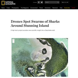
The maps were made by flying drones low over the St. Joseph atoll in the outer Seychelles, a 10 square-mile (25 square-kilometer), uninhabited island that was designated as a protected marine reserve in July 2014. A small team from the Switzerland-based nonprofit group Drone Adventures spent a week flying their drones over the area, with support from the Geneva-based nonprofit Save Our Seas Foundation. "Drones are an amazing tool for research," says Michael Scholl, the CEO of Save Our Seas. Maximizing the Value of IoT Data. The explosive growth of data generated by the Internet of Things is creating enormous business value for the enterprise.
While most organizations adhere to the traditional cloud-centric approach to processing and managing IoT data, few are realizing the enormous benefit of applying some level of integrated intelligence at the edge of the network as well. To fully maximize the value of IoT data, organizations must employ strategic architectures that embrace the inherently distributed nature of the Internet of Things. “With the volumes of data generated by IoT solutions, existing storage capacity can be quickly overwhelmed. A limited ability to cost-effectively scale existing storage approaches will create a bottleneck.
Source: Ten Critical Information Infrastructure Implications for Your 'Internet of Things' Initiatives. A Complete Guide to LiDAR: Light Detection and Ranging - GIS Geography. What is Light Detection and Ranging (LiDAR)?
How would you like to wave your magic wand and all of a sudden find out how far everything is away from you? No magic wands necessary. This is how LiDAR (Light Detection and Ranging) works – minus the magic wand. LiDAR is fundamentally a distance technology. An airborne LiDAR system actively sends light energy to the ground. A Complete Guide to LiDAR: Light Detection and Ranging - GIS Geography. Drones and GIS: A Look at the Legal and Ethical Issues. The use of drones to acquire geographic information has rapidly been adopted by the geographic information community as an essential data gathering tool.
Used to acquire information cheaply from inaccessible or remote areas, drones have already been helped in assessing archeological sites and mapping threatened plant species in Michigan. As compared with traditional methods of gathering imagery via aircraft, drones offer a cheaper and quicker method of gathering higher resolution geographic information (UAV and GIS, 2014). However, along with the benefits that drones provide in gathering information are some tricky ethical and legal issues.
Preorder Snap Flying Camera. Understanding Our Changing Planet — Development Seed. OpenGeofiction. How Earth Observation Startups & CubeSats are changing the industry. The Earth Observation and Space Exploration industry is certainly abuzz with activity and already several start ups have entered into an arena where traditional only governments and national space organizations were absolute.
The entrance of startups has certainly made the Earth Observation and Space Exploration more interesting and has accelerated innovations, not that the national space organizations were not doing it already. If SpaceX is leading the innovation drive towards reusable rockets then SkyBox imaging and Planet Labs are certainly the most visible faces in the satellite imagery startup orbit. Interestingly, Earth Observation Startups or Satellite Imagery startups are not exactly changing the industry just because of technological superior or cost effective satellites; they are essential changing the earth observation industry by literally using small satellites compared to the gigantic and heavy satellites that the national space organizations launch every year. Downloads. The Huge, Unseen Operation Behind the Accuracy of Google Maps. Inside Atlas, Google’s map-editing program, operators can see where Street View cameras have captured images (colored dots), and zoom in with a spyglass tool.
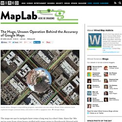
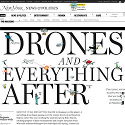
Google Maps The maps we use to navigate have come a long way in a short time. Since the ’90s we’ve gone from glove boxes stuffed with paper maps to floorboards littered with Mapquest printouts to mindlessly obeying Siri or her nameless Google counterpart. AirCasting. Drones and Everything After. Drones And Everything After The flying, spying, killing machines that are turning humans into superheroes.
La géolocalisation, nouvel eldorado du marketing mobile ? Le smartphone est devenu une extension de nous-même : pour trouver une adresse, vérifier un prix, consulter les avis des consommateurs.
La géolocalisation serait une nouvelle sorte de cookie, plus efficace que son cousin du desktop. L'angleterre ferme son calculateur d'itinéraire national. Lancement du projet LoRa FABian : déploiement d’une couverture radio longue portée pour les objets communicants à Rennes › Lexians. Un article publié dans Lexians, la lettre d'information de Télécom Bretagne.
How Google Map Hackers Can Destroy a Business at Will. Rene Bertagna blames Google for the death of his restaurant, Serbian Crown. Courtesy Rene Bertagna Washington DC-area residents with a hankering for lion meat lost a valuable source of the (yes, legal) delicacy last year when a restaurant called the Serbian Crown closed its doors after nearly 40 years in the same location. The northern Virginia eatery served French and Russian cuisine in a richly appointed dining room thick with old world charm.
It was best known for its selection of exotic meats—one of the few places in the U.S. where an adventurous diner could order up a plate of horse or kangaroo. “We used to have bear, but bear meat was abolished,” says proprietor Rene Bertagna. Pourquoi la presse en ligne veut vous géolocaliser à quelques mètres près. How Earth Observation Startups & CubeSats are changing the industry. Predicting the Future of Global Geospatial Information Management. Maps from the Crowd in Crisis context / OpenStreetMap Response to h... Best Views of Earth From Europe’s New Plant-Mapping Minisatellite.
The Sinai Peninsula, taken by Proba-V on March 24, 2014. A colored vegetation index of the Mekong Delta in Vietnam, derived from Proba-V data in 2013. The Nile Delta in Egypt taken by Proba-V on March 24, 2014. False-color image showing deforestation in Brazil, taken by Proba-V on Feb. 4, 2014. India from Sri Lanka to the Himalayas, taken by Proba-V on March 14, 2014. Ash and gas plumes from Sicily's Mt. Ngorongoro crater in Tanzania, taken by Proba-V on Jan. 31, 2014. A different angle on South America, taken by Proba-V on April 23, 2014 Bolivia's Salar de Uyuni, the largest salt flat in the world, taken by Proba-V on March 31, 2014.
ITIS-Big Data & Open Data. La cartographie de l’épidémie d’Ebola est en ligne - France. Il n'existe aucun traitement ou vaccin contre la fièvre Ebola, qui se transmet par contact direct avec le sang ou les tissus biologiques des sujets infectés, qu’ils soient humains ou les animaux, vivants ou morts.
VISOV Suivi Epidémie Ebola Afrique de l'Ouest - Mars/Avril 2014. "Montrer l'invisible" de nos villes grâce à la cartographie numérique. La contribution d'Internet à la lutte contre Ebola: cartographier la Guinée. Ça a l'air d'un simple détail technique, et pourtant, cette initiative risque fort d'être décisive. APIs + heaps of satellite imagery: searching for flight MH370. They Protect Endagered Animals.
Tracking animals in a remote wilderness isn't easy. If they're endangered species, there may be only a few examples to count. And then there's the rough and vast terrain itself. They Protect Endagered Animals. L'open data et le crowdsourcing réunis en une embarrassante carte interactive contre la déforestation. Mapping Nairobi's Crazy Informal Transit System For The First Time. If you need to go somewhere in Nairobi, there’s a good chance you’ll get in a “matatu. " Since the city doesn’t have an official bus system, these privately owned vans--often beaten up and decorated with street art and neon lights--are pretty much the only public transportation option. But until recently, the chaotic web of matatu routes has also been near impossible to decipher, since the system had no official map.
Now that’s finally changing. A group of researchers, designers, and students has mapped out the city’s 130 transit routes and created an open dataset that can be updated continuously. “We wanted to render visible the public transit system,” says Jacqueline Klopp, an associate research scholar at Columbia University's Center for Sustainable Urban Development.
Google launches "Project Tango": The 3D Mapping & Navigation SmartPhone. Home / Geo NEWS / Google launches “Project Tango”: The 3D Mapping & Navigation SmartPhone Google has announced the launch of its computer vision and 3D sensors project “Project Tango”: essentially a smartphone prototype with advanced 3D sensors. This new prototype doesn’t just have motion sensors but actually allows 3D scanning thereby opening up a whole lot of possibilities for Computer Vision and 3D Mapping/Navigation. The application that interests us geoawesome people the most – Indoor Mapping & Navigation! LiDAR and the Archaeology Revolution. There is no doubt that remote sensing technology has created a dramatic shift in the past few years concerning how scientists and researchers gather and analyze information about the Earth.
Remote sensing, the use of satellites or aircraft to gather data about objects from a distance, has an almost infinite number of applications. This kind of technology has been used to monitor the environment, map the ocean, explore the Polar Regions, and much more. Skybox Imaging - Welcome. De quel espace l’internet est-il la carte. Observatoire français des applications civiles du drone. Good luck, Planet Labs! Update, Thursday morning: The Nature of Geographic Information.
Cheap Drones Are Transforming The Ancient Art Of Mapmaking ⚙ Co. Un algorithme devine votre mode de transport grâce à votre téléphone. Dans la rubrique les algorithmes sont nos amis, on apprend qu’une équipe de chercheurs de l’Institute for Information Technology d’Helsinki vient de mettre au point un système qui détecte grâce à votre smartphone le mode de transport que vous empruntez en ce moment même… TMD-Peaks, c’est son nom, utilise le principe de l'accéléromètre pour repérer les mouvements et détecter, à partir des accélérations et des freinages, le véhicule utilisé.
Les expériences menées ont montré une amélioration de 20% de la détection des modes de transport par rapport aux capacités des systèmes actuels, écrivent les chercheurs. Will Grindr and Google Glass kill the map? The smell of the city. Drones : le point de vue des pros ! SNCF : pour utiliser des drones de surveillance, la DGAC doit faire évoluer ses règles.
Toute l'actualité des drones. This Drone Gives Google Earth Tech To Public. Moving_large_map.png (Image PNG, 983x552 pixels) Drone4u, un projet de recherche mené par une équipe de Télécom ParisTech et d’EURECOM sur des mini-drones grand public. Waze. De l’internet des objets au web des objets. IndoorOSM - OpenStreetMap Wiki. Crowdcrafting: Putting Citizens in Control of Citizen Science. Villes intelligentes : le Big Data va modeler les villes de demain. GPS Devices in Tracking, Fitness and PNDs: Market to reach $ 7 Billion in 2018! Are crowdsourced maps the future of navigation? Google’s Road Map to Global Domination. Robertson Library Hacker in Residence. IndoorOSM.