
Les shields/breakout et modules radio. Nous avons développé une gamme de shields pour Arduino/Genuino et Raspberry-pi qui permettent d’utiliser plusieurs protocoles radio et des modules (transcievers) variés pour des développements de projets et objets connectés.
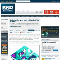
Un point rapide pour vous aider à choisir parmi les produits que nous vous proposons dans la catégorie IoT de notre site. Nous accompagnons chaque année des entreprises dans leurs projets spécifiques. Nous avons un penchant pour les projets dans des secteurs industriels à l’environnement « hardcore » (température, humidité, poussière, vibrations, chocs, autonomie, etc.). Choisir selon son stade de développement : IndoorAtlas Vies for Position in RTLS Market. Finnish technology company IndoorAtlas sells location-tracking software that it says can leverage Earth's magnetic field to map the unique magnetic signature inside modern steel-structured buildings, and then determine the locations of smartphones moving within those spaces, to an accuracy of 1 to 2 meters (3.3 to 6.6 feet).
Its technology, the company reports, enables businesses to communicate with consumers via their smartphones, while requiring less infrastructure and providing greater location granularity than beacon- or Wi-Fi-based alternatives. Last week, IndoorAtlas announced that it has signed an agreement with Yahoo Japan through which Yahoo Japan will employ IndoorAtlas' geomagnetic position technology to map indoor spaces and provide indoor location-based services in Japan. This follows six months during which Yahoo Japan tested the technology in Tokyo.
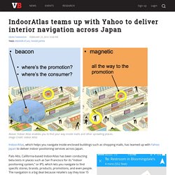
IndoorAtlas teams up with Yahoo to deliver interior navigation across Japan. IndoorAtlas, which helps you navigate inside enclosed buildings such as shopping malls, has teamed up with Yahoo Japan to deliver indoor positioning services across Japan.
Palo Alto, California-based IndoorAtlas has been conducting beta tests in places such as San Francisco for its “indoor positioning system,” or IPS, which lets you navigate to find specific stores, brands, products, promotions, and even people. The navigation is a big deal because retailers say they lose 15 percent of sales because consumers cannot find the store or the product they’re looking for.
IndoorAtlas said it was chosen because of its scalability, accuracy, ease of deployment, and the developer program that lets others build apps on top of its location service. The partnership will lay the foundation for enriching Japan’s smartphone maps. And it will boost usage of IndoorAtlas, as Yahoo Japan generates 63 billion page views per month. Why the indoors could be the next frontier for map-makers. I am in the United Arab Emirates, commentating on England’s Test series against Pakistan.
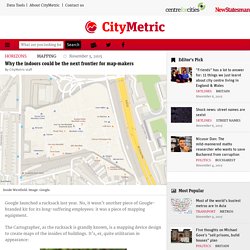
Not long after the first day’s play in Dubai, I witnessed a revealing scene. A few dozen England fans – a good portion of the crowd – had to wait 90 minutes outside the ground for a taxi. Some people were at street level and the system short-circuited. Cities are usually set up to supply the needs of crowds. Dubai is predicated on the absence of pedestrians. Why didn’t the cricket fans walk? Literalism reigns. On the way to the cricket ground in Sports City, we drove through Media City. Google Unveils The Cartographer, Its Indoor Mapping Backpack. If you have been following the development of Google Maps over the years, you are probably familiar with the Trekker, the backpack that includes a complete Street View camera setup for mapping anything from hikes into the Grand Canyon to walks through penguin colonies in Antarctica.
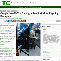
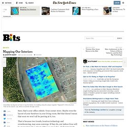
Today, a new backpack is joining Google’s mapping tools: the Cartographer for indoor mapping. The Cartographer uses a process called “simultaneous localization and mapping” (SLAM), a technique that’s typically used for mapping new locations and that Google is now putting to use to map anything from hotels to museums. As the backpacker walks through a building, the floor plan is automatically generated in real time, Google says. The wearer also uses a tablet to add points of interest while walking around the building (say room numbers in a hotel or the exhibits in a museum). GISI Indoors. Mapping Our Interiors. IndoorAtlasIndoorAtlas has figured out how to map the interior of a building using the unique magnetic “fingerprint” of the structure.
That can be used to, say, direct a customer through a store. Sure, that’s your office cubicle. Your corner store. Maybe even the layout of your furniture in your living room. GPS Indoor Maps are Here: Never Get Lost In a Mall, Museum, or Hospital Again. Last month, Apple confirmed its acquisition of WiFiSLAM, a Silicon Valley-based startup that specializes in indoor mapping.
Despite a lack of details from Apple regarding its plans for the startup, stories pegging WiFiSLAM as the company’s latest weapon in its mapping arsenal flooded the news stream. Apple buys indoor-mapping startup WiFiSlam. Indoor Venues Are The Next Frontier For Location-Based Services. Blog.wifislam.com.
New Indoor Navigation Startup Uses Disruption Of Earth's Geomagnetic Field From Buildings. While the homing pigeon is known for navigating back home over long distances, some other animals, such as the spiny lobster, are able to do the same on a more local level.
Research has given some idea that these animals are able to derive positional information from cues that arise from the local anomalies of the Earth's magnetic field. Une alliance d'acteurs importants dans la géolocalisation d'intérieur. Une vingtaine d'entreprises liées aux secteurs high-tech et de la cartographie se sont constituées en une alliance pour développer le marché de la localisation à l'intérieur des bâtiments.
Baptisé In-Location Alliance, le consortium regroupe notamment Nokia, Samsung, Sony Mobile Communications et Broadcom ainsi que des sociétés spécialisées dans la géolocalisation. L'alliance donne quelques exemples de possibilités offertes par la localisation d'intérieur, comme le fait de pouvoir trouver plus facilement des personnes ou bien d'améliorer la sécurité en cas de situation d'urgence. Le côté commercial n'est pas non plus oublié avec par exemple la possibilité de déployer des ressources plus rapidement et plus précisément.