
Cartographie de l’accessibilité avec des enfants valides/non valides. Le projet collaboratif Cartomobilité continue à apporter son lot de bons moments partagés !
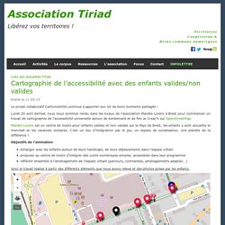
Lundi 20 avril dernier, nous nous sommes rendu dans les locaux de l’association Planète Loisirs à Brest pour commencer un travail de cartographie de l’accessibilité universelle autour de Kerbernard et de Pen ar Creac’h sur OpenStreetMap. Planète Loisirs est un centre de loisirs pour enfants valides et non valides sur le Pays de Brest, les enfants y sont accueillis le mercredi et les vacances scolaires. C’est un lieu d’intégration par le jeu, un espace de socialisation, une planète de la différence ! Objectifs de l’animation échanger avec les enfants autour de leurs handicaps, de leurs déplacements dans l’espace urbainproposer au centre de loisirs d’intégrer des outils numériques simples, accessibles dans leur programmeréfléchir ensemble à l’aménagement de l’espace urbain (parcours, contraintes, aménagements adaptés...)
Voir en plein écran Les cartographes du jour Déroulé de l’animation 10h15 à 10h30. Golf Course at Centimeter Accuracy - From an iPhone into OpenStreetMap. While browsing OpenStreetMap around the world-famous Riviera Country Club Golf Course, I noticed that it was pretty empty.
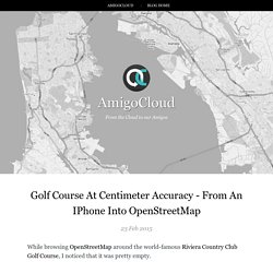
No fairways, sand traps, greens, holes :-( It just so happens that, a few days ago, one of our team members was at this location collecting submeter data using an iPhone. Most smartphones nowadays have a built-in GPS device that gives you approximately (at best) ~5 meter horizontal accuracy. For this particular project, we needed something much better. With a few clicks, we connected (via Bluetooth) our Android and iPhone devices with a high precision SXBlue GPS/GNSS receiver to our AmigoCloud Data Collection Application. If you are interested in the actual process of setting up a data collection project (it takes less than 5 minutes and doesn't require you to install any software in your computer) you can watch the video of our webinar last week where we walked through it (skip to 13m:26s for details).
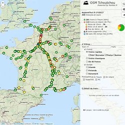
The data collection process itself involves: Agir pour aider dans la lutte contre Ebola. ViziCities: Creating Real-World Cities in 3D using OpenStreetMap an... Slide: auto-drawing geometry to remove the pains of map tracing. OSM Tchoutchou - Raildar with Leaflet and Open Street Map. 100 km Leaflet | Map data © OpenStreetMap contributors, CC-BY-SA, Imagery © Mapquest OSM Tchoutchou Powered by Raildar.fr Aujourd'hui à 17:53:17 335 missions en cours 201 trains à l'heure (60%) 123 trains en retard (36.7%) : Moins de 15min : 76 Entre 15 et 30min : 39 Plus de 30min : 8 0 trains supprimés (0%) 11 sans info temps-réel (3.3%) Filtres : Train n° Trafic France Europe Ponctualité Détail du train : Survolez un train pour en voir les détails À propos : Voir le wiki du projet Chargement ...
Extracting data from OpenStreetMap... To build nice applications. Migurski/Extractotron. Kort App. Mobile Web-App to fix OpenStreetMap data.
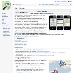
(play.kort.ch) (open with HTML5 compatible browser) The app uses the concept of gamification to motivate users to regularly use it. This means, that game-like elements are used like winning points and badges to climb the highscore. The points (so called Koins) are collected by the players by fulfilling tasks. Examples of tasks are POIs without a name, where the user has to enter the missing name. All changes to OpenStreetMap are made by the OSM-user kort-to-osm. Community Twitter: (Hashtag #KortGame) Github (for reporting error or pull requests): UserVoice (for general feedback): (replace .xxx with .com, spam filter blocks uservoice.com) Geoclub (forum, sorry: german): Background Information Missions Bugs are downloaded every night from Keep Right. Documentation Informations about the missions (error types) Kort campaigns supported devices ...see Kort Game Wiki on GitHub. Kort Game in the media See DE:Kort_Game. Atlas - fieldpapers.org.