
Tidal Datums. Tidal Datums In general, a datum is a base elevation used as a reference from which to reckon heights or depths.
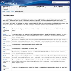
A tidal datum is a standard elevation defined by a certain phase of the tide. Tidal datums are used as references to measure local water levels and should not be extended into areas having differing oceanographic characteristics without substantiating measurements. In order that they may be recovered when needed, such datums are referenced to fixed points known as bench marks. Tidal datums are also the basis for establishing privately owned land, state owned land, territorial sea, exclusive economic zone, and high seas boundaries. *Some locations have diurnal tides--one high tide and one low tide per day. References All documents available at Navigating the Datums Page The Datums page (example at right) provides access to established datums for the station indicated in the upper left corner of the page.
The data can be displayed in either feet or meters. DATUMS AND DATUM TRANSFORMATIONS. This software is brought to you by the Topographic Engineering Center, a US Army Corps of Engineer Lab ( ).by: Dan Specht 25 Sep 1998 with corrections by Ray Caputo 18 July 2002. 1.3 What is the difference between WGS 84 and GRS 80?
Not much difference! Ref: North American Datum of 1983 NOAA Professional Paper NOS 2 Charles R. Schwarz, Editor U.S. Department of Commerce by:Sam Wormley swormley@cnde.iastate.edu 3/7/97 1.4 How do I convert between NAD83 and WGS 84? I think the proposition of doing a "datum shift" between NAD83 and WGS84 is a waste of time. The ellipsoid of the World Geodetic System of 1984 is defined by four constants, one being the "bar C sub 20" Normalized Second Degree Zonal Harmonic Coefficient of the Gravitational Potential - the "J2" term is computed.
The differences between the semi-minor axes are computational (secondary DEPENDENT) variables based on different definitions of the gravity field. By: Clifford J. (Codes are used in NGS software.) by: Donald M. Where Nope. NAD 83. Frequently Asked Questions (FAQ) about the National Geodetic Survey can be found either by entering ctrl-F to search for a word relevant to your question or by reviewing the material under one of the topics listed below.
Aeronautical Survey Program Height Modernization Program Continuously Operating Reference Systems (CORS) Online Positioning User Service (OPUS) What is a Geoid? If you still have a question after scanning these FAQs, please contact the Communications and Outreach Branch. Datums What are NAD 27 and NAD 83? Why did NGS change from NAD 27 to NAD 83 ? What is the CORS network? Positions I have the latitude and longitude for a particular site. Software What languages are NGS software products written in? What & Why What are the "official" conversions that are used by NGS to convert 1) meters to inches, and 2) meters to feet? Datums Questions and Answers What are NAD 27 and NAD 83? Why did NGS change from NAD 27 to NAD 83? How do the horizontal datums differ? What is HARN or HPGN?