
Photos & Videos. Photos & Videos. Across northern Africa, the desert is steadily growing.
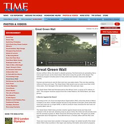
Parched lands are spreading. But a bold project known as the Great Green Wall aims to stop the growth of the desert. The ambitious program includes plans to help protect and maintain resources and fight poverty. Farmers are learning to care for their land and use water wisely. They are also planting millions of trees and crops.
The Great Green Wall was first approved by the African Union, a group of 53 nations, in 2007. A Barrier Against the Desert According to the U.N. The Great Green Wall's trees provide a barrier against desert winds and help hold moisture in the air and soil, allowing crops to grow. Trees and crops have been planted in Senegal and Niger. Geography Of Africa. Geography of Africa. World Political MapMaker Kit. About This MapMaker Kit The World Political MapMaker Kit maps include country boundaries, city names, and other political features. For a world map without country boundaries see the World Physical MapMaker Kit.
Download, print, and assemble maps of the political world in a variety of sizes. Ancient Mesopotamia Song By Mr. Nicky. THIS DARK EARTH: Bridge City and The Ruins of Tulaville. Mapping zombies. Using a keyword search for "zombies", the following map visualizes the absolute concentrations of references within the Google Maps database.
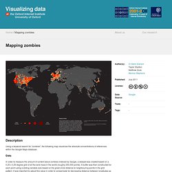
Data In order to measure the amount of content about zombies indexed by Google, a dataset was created based on a 0.25 x 0.25 degree grid of all the land mass in the world (roughly 250,000 points). A buffer was then constructed for each point using a sliding variable size based on the great circle distance to neighbouring points in the grid pattern. It was important to adjust this value in order to compensate for decreasing distance between longitudes as the software moves from the equator to the poles. For each point and buffer combination a search was run in Google Maps to measure the total number of hits for user-generated content at each location (as defined by Google).
Findings. U.S. States Most And Least Likely To Survive The Zombie Apocalypse. Given the growing frequency with which zombies appear in movies, TV shows, and your worst nightmares, it’s inevitable the zombie apocalypse will soon be upon us.
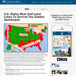
When it comes to surviving this inevitable showdown with the undead, location is everything. Do you live in a state populated with zealous zombie fighters capable of beating back hordes of brain-hungry walking dead? Estately answered this question with its Zombie Apocalypse Preparedness Rankings, which were determined using the 11 metrics below that measure fighting ability, knowledge of zombies, physical fitness, and access to weapons… Below is a complete ranking of the 50 states based on zombie apocalypse preparedness. Those at the top are the most likely to survive and those at the bottom are the least likely to.
From the rankings, we discovered these surprising truths… Profile of the 10 States Most Prepared To Survive Zombie Apocalypse 1st—ALASKA 2nd—WYOMING 3rd—COLORADO. Www.owlteacher.com/support-files/fivethemesofgeographyactivity.pdf. 1Q: Zombie Apocalypse-Survival Plan. Geography & Map Skills Battleship. Geography Battleship.pdf. Lesson Plan: 10 Ways to Teach About Geography. Lalo de Almeida for The New York TimesPopulation growth in the Brazilian jungle is visible in places like Parauapebas.
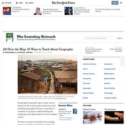
On the outskirts, slums stretch to the horizon and houses continue to go up. Go to related article » Geography frequently takes a back seat to history in the social studies classroom, but teaching geographic literacy is essential if students are going to understanding the challenges and opportunities of our complex world. We have created 10 activities for teaching about geography using Times content, all related to the National Geography Standards, which were produced by the Geography Education National Implementation Project.
Our list is a grab-bag of ideas — from designing maps to analyzing border conflicts — and teachers can use the activities in any order, or as a road map for tracking ongoing coverage of geography-related issues.1. How do you decide where to go in a zombie apocalypse? - David Hunter. Fun with Geography. 2013 National Geographic Bee's Final Moments. What can you do with geography? Why we need to teach geography.mov. The 5 Themes of Geography. 7th Grade Map Skills Worksheets - Powered By OnCourse Systems For Education. More on My Social Studies Interactive Notebook. Infographic List. Historic Center of Florence - Google Cultural Institute. Spherical 360 Video.