
Natural Earth. 6 CARTOGRAPHIE. 25 Maps (25 pics) Pics | 11 Dec, 2013 | Views: 12871 | 25 maps that will help you to see the world better.

This map shows the world divided into 7 sections with each section containing 1 billion people This map shows where 2 percent of Australia's population lives It may not come as a surprise but more people live inside the circle than outside of it This map shows what is on the other side of the world from where you are standing. Apparently you can't get Big Macs everywhere. This time the countries in red drive on the right side of the road The countries in white are the ones that England has never invaded. These were all of the world's internet connections in 1969 And these are all the countries that heavily restrict internet access today.
Cartes. Space. Sismic. Global Incident Map Displaying Terrorist Acts, Suspicious Activity, and General Terrorism News. Cytoscape: An Open Source Platform for Complex Network Analysis and Visualization. Carto / maps / plans. Web Maps. Flash Earth - Zoom into satellite and aerial imagery of the Earth in Flash. Géoportail - le portail des territoires et des citoyens. Mapping Wikipedia. Wind Map: Historical. An invisible, ancient source of energy surrounds us—energy that powered the first explorations of the world, and that may be a key to the future.

This map shows you a historical snapshot of the delicate tracery of wind flowing over the US. See the live map for current winds. Wind map prints are available from Point.B Studio. Read more about wind and about wind power. The wind map is a personal art project, not associated with any company. If the map is missing or seems slow, we recommend the latest Chrome browser. Surface wind data from the National Digital Forecast Database. If you're looking for a weather map, or just want more detail on the weather today, see these more traditional maps of temperature and wind.
[Site d’accompagnement CARMEN] La revue Mappemonde. Worldometers. Spain map of Spanish Camps by Provincia - TargetMap-Mozilla Firefox. About Anthropogenic Landscapes. Cartes-Atlas-Plans de villes. Kepler Exoplanet Candidates. A propos de l'OCDE. OECD Home › A propos de l'OCDE Notre mission La mission de l'Organisation de Coopération et de Développement Économiques (OCDE) est de promouvoir les politiques qui amélioreront le bien-être économique et social partout dans le monde.

L’OCDE offre aux gouvernements un forum où ils peuvent conjuguer leurs efforts, partager leurs expériences et chercher des solutions à des problèmes communs. Nous travaillons avec les gouvernements afin de comprendre quel est le moteur du changement économique, social et environnemental. Nous mesurons la productivité et les flux mondiaux d’échanges et d’investissement.
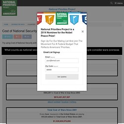
Nous examinons également le coût des impôts et de la sécurité sociale pour les citoyens, ainsi que le temps libre dont ils disposent. En nous appuyant sur les faits et l’expérience concrète, nous recommandons des politiques dont le but est d’améliorer la vie de l’homme de la rue. Let's describe the whole world! Internet Statistics & Social Media Usage. Worldmapper: The world as you've never seen it before. Mapping America — Census Bureau 2005-9 American Community Survey. PopulationMondiale.com - World population clock : suivez l'évolution de la population du Monde en direct ! Narrated animation of March 11, 2011 Honshu, Japan tsunami propagation. Cost of War to the United States. About | Embed | Localize | Military To embed the Department of Defense (FY2014) counter on your website, blog, etc, follow these simple instructions: 1) Add the following javascript to your page: Add the following code wherever you want the counter to show up: NOTE: This doesn't need to be a <div>.
Use whatever tag you need. A Note About Style We've intentionally left out any styles for this embeddable counter, instead leaving it up to you to provide styles consistent with the look of your site. Global Network for the Forecasting of Earthquakes. NASA brengt temperatuurverandering in kaart. De Nederlandse Publieke Omroep maakt gebruik van cookies.

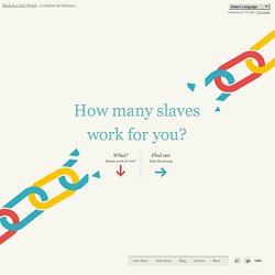
We maken een onderscheid tussen functionele cookies en cookies voor het beheer van webstatistieken, advertenties en social media. De cookies bevatten geen persoonsgegevens en zijn dus niet tot een individu te herleiden. Met de cookies voor advertenties en social media worden mogelijk door derden gegevens verzameld buiten de websites van de Nederlandse Publieke Omroep. Bij instellingen kun je aangeven deze cookies niet te accepteren. Sightsmap. The Radiation Database v1.1 for Google Earth - The World's Most Powerful Radiation Sources. Mapping Stereotypes Project by alphadesigner. The Atlas of the Real World. Slavery Footprint - Made In A Free World. Made in a Free World - A solution for business.
Powered by Translate Slavery Footprint. Piri Reis. Enigme de l'histoire. En Images. Quand l’Antarctique n’était pas recouvert de glace Piri Reis de son vrai nom « Piri Ibn Haji Memmed, l’amiral Reis, est un Turc.
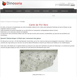
Dans les notes qui accompagnent le document, il affirme que certaines des vingt cartes qui lui ont servi de sources datent d’Alexandre le Grand et que d’autres sont fondées sur les mathématiques. Cette carte a été étudiée par le capitaine Mallery qui découvre que cette carte représente une partie de l’Antarctique. Ce continent est pourtant recouvert de glaces depuis au moins 10 000 ans et n’a été découvert officiellement qu’en 1818. El Hierro, la isla de los mil volcanes. China Media Map. Map data ©2014 AutoNavi, Google, SK planet, ZENRIN Terms of Use.
Fichier:KangnidoMap.jpg - Wikipédia. Ulmpto2.jpg (JPEG Image, 960x689 pixels) Occupy Wall Street Map Showing Social Media Relating to the Protests. Global Incident Map Displaying Terrorist Acts, Suspicious Activity, and General Terrorism News. L'édition sous licence libre, une utopie ? Welcome to the World of Historic Maps. Ceriscope. Visual Understanding Environment.
Carte des points d'accès déployés. Flash Earth - Zoom into satellite and aerial imagery of the Earth in Flash. Interactive. The World of Seven Billion The map shows population density; the brightest points are the highest densities.
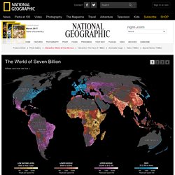
Each country is colored according to its average annual gross national income per capita, using categories established by the World Bank (see key below). Some nations— like economic powerhouses China and India—have an especially wide range of incomes. But as the two most populous countries, both are lower middle class when income is averaged per capita. NASA Earth Observatory : Home. 10000+ online newspapers in the world, translate with one click. ANFR Agence Nationale des Fréquences. Ship locations map. Flightradar24.com - Live Flight Tracker!-Mozilla Firefox. Météo Europe par Satellite, précipitations, Nuages et Soleil au-dessus continent Européen.
US Navy Earth Changes USA Flood Map, New Madrid Earthquake Zone: What Does the Navy Know? Live Ships Map - AIS - Vessel Traffic and Positions. Argefo. Breathingearth - CO2, birth & death rates by country, simulated real-time. Antivoitures: Parc automobile mondial en temps réel. Earth album alpha - a slicker google maps + flickr mash-up. Home Jump to or earth album - earth album earth album is a simpler, slicker Flickr mash-up that allows armchair tourists to explore some of the most stunning photos in the world courtesy of Google maps and Flickr.
To begin your journey, just click anywhere on the map, e.g. "India". Since the top Flickr images are used, the images change every few weeks; bookmark this site and check back for a different experience in a month! Time Magazine Top 10 Website of 2006 ∞ PC Magazine Top 100 Undiscovered Websites ∞ front page of digg. World Digital Library Home. GeoRezo, le Portail de la Géomatique et des SIG (Systèmes d'Information Géographique) Cartothèque : Sommaire. Accueil: Aviso. L’eau sous nos pieds cartographiée depuis l’espace ( , 2014/04)Pour sauver nos océans, un changement culturel s'impose (Libération, 2014/04/10) 2036 ou quand le réchauffement climatique atteindra un seuil critique (Slate, 2014/04/08) La disponibilité des articles en ligne varie selon les journaux.
Nous ne pouvons donc garantir que les articles mentionnés ci-dessus soient accessibles de façon permanente. Lire la suite Le 15 avril 2014, une nouvelle version des produits SSALTO/ Living Planet Programme - GOCE. Earth. LUXORION - 1810 pages, 20000 images, 3 GB online (c)2000-2011, LUXORION.