background preloader

Movilidad

Facebook Twitter

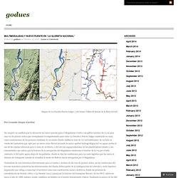
Multimodalidad y nuevo puente en “La Glorieta Nacional” « godues. Multimodalidad y nuevo puente en “La Glorieta Nacional” Posted by godues on October 15, 2012 · Leave a Comment Mapas de La Dorada-Puerto Salgar y del tramo Villeta-El Korán de la Ruta del Sol Por Gonzalo Duque Escobar Al “punto cero” de la navegación del Magdalena definido por el proyectado Puerto Multimodal de La Dorada que deberá construirse aguas abajo de Puerto Salgar-La Dorada, vecino al Korán (Cundinamarca) donde se articulan los tramos 1 y 2 de la Ruta del Sol que viene de Villeta para continuar hacia San Roque y como tal un punto obligado para la Autopista Bogotá-Medellín, además punto de venida del proyectado Ferrocarril de trocha estándar Neiva-La Dorada que arribará por la rivera de Caldas, llegarán dos vías de la cuarta generación de concesiones dispuestas a lo largo del río: las carreteras Ibagué-La Dorada por su margen occidental y Girardot-Puerto Salgar por la margen de Cundinamarca, para continuar hacia Santa Marta. * Prof.

Relacionados:

Carros

Www.nber.org/papers/w15376.pdf. Europe Stifles Drivers in Favor of Mass Transit and Walking. Christoph Bangert for The New York Times Pedestrians and trams are given priority treatment in Zurich. Tram operators can turn traffic lights in their favor as they approach, forcing cars to halt. More Photos » Cities including Vienna to Munich and Copenhagen have closed vast swaths of streets to car traffic. Barcelona and Paris have had car lanes eroded by popular bike-sharing programs. Drivers in London and Stockholm pay hefty congestion charges just for entering the heart of the city. Likeminded cities welcome new shopping malls and apartment buildings but severely restrict the allowable number of parking spaces. “In the United States, there has been much more of a tendency to adapt cities to accommodate driving,” said Peder Jensen, head of the Energy and Transport Group at the European Environment Agency.

To that end, the municipal Traffic Planning Department here in Zurich has been working overtime in recent years to torment drivers. Subways would cost more and serve fewer, think tank says. Zoom Penny-pinching Mayor Rob Ford’s subway plan would cost three times as much per kilometre to build as the four Metrolinx-funded light rail lines and attract only half as many riders, says a study released Wednesday by a sustainable-energy think tank.

It suggests Ford’s subway expansion plans would cost about $344 million per kilometre and attract about 65 million rides annually. By comparison, 75 kilometres of light rail would run $111 million per kilometre and draw about 126 million rides a year, says the report, Making Tracks to Torontonians, by the Pembina Institute. Metrolinx had agreed to spend $8.15 billion on the first 50 kilometres of the Transit City light rail plan. The report, released in conjunction with the Toronto Environmental Alliance, compares two scenarios: • Putting light rail on Sheppard, Finch, Eglinton and converting the Scarborough RT to the same light rail technology. Ford hasn’t endorsed any specific plans yet.

Waze.com, una red social para evitar trancones - Noticias de Tecnología en Colombia y el Mundo. El servicio gratuito Waze llegó en octubre al país y ya cuenta con 25.000 usuarios. No se trata de una red social común y corriente, pues no se enfoca en buscar amigos, sino en colaborar con otros para mantenerse informados sobre la situación del tráfico en las caóticas vías de buena parte de Colombia y de otros países. Aunque la aplicación cuenta con mapas del 85 por ciento de las carreteras del país, por ahora es más utilizado en Bogotá, Cali, Medellín, Barranquilla, Cartagena y Villavicencio. Para beneficiarse de ella es necesario contar con un teléfono inteligente con Sistema de Posicionamiento Global (GPS). La conexión satelital reporta cada dos segundos la ubicación y la velocidad del usuario, que se ven reflejadas en un preciso mapa que aparece en la pantalla del celular -si usted tiene un plan de datos, claro-.

Los conductores también pueden hacer sus propios reportes mediante clics o mensajes de texto. Amigos, estados de ánimo y 'tweets' Free GPS Navigation with Turn by Turn - Waze | New Carsharing Association Aims to Reduce Car Ownership. The CarSharing Association seeks to brand carsharing as "good for your community, your planet and your wallet. " Image via the CSA. Eighteen carsharing companies from around the world recently formed a new association that emphasizes the environmental and social impact of their work, with a focus on reducing car ownership and promoting integrated public transportation. It makes sense that carsharing leaders would eventually come together to share common goals and business practices, considering the growth of the industry, especially in North America. Two weeks ago, the CarSharing Association (CSA) became official. The CSA aims to improve the credibility, quality of service and general awareness of carsharing by acting as a “unified industry voice” that “supports its members, their constituents and the communities in which they operate.”
The member companies represent more than 2,000 shared cars used by 50,000 people. Transport 2050: Commission outlines ambitious plan to increase mobility and reduce emissions. Brussels, 28 March 2011 Transport 2050: Commission outlines ambitious plan to increase mobility and reduce emissions The European Commission today adopted a comprehensive strategy (Transport 2050) for a competitive transport system that will increase mobility, remove major barriers in key areas and fuel growth and employment. At the same time, the proposals will dramatically reduce Europe's dependence on imported oil and cut carbon emissions in transport by 60% by 2050. To achieve this will require a transformation in Europe's current transport system. By 2050, key goals will include: - No more conventionally-fuelled cars in cities. - 40% use of sustainable low carbon fuels in aviation; at least 40% cut in shipping emissions. - A 50% shift of medium distance intercity passenger and freight journeys from road to rail and waterborne transport. - All of which will contribute to a 60% cut in transport emissions by the middle of the century. 1. 2. 3.

Capital looking to end gridlock in five years. By Wang Wei (China Daily) Updated: 2010-12-09 08:01 Beijing has drawn up an ambitious plan to solve its gridlock problem and get traffic moving again. Liu Qi, the capital's Party chief, said the State Council has approved the city's traffic management plan in principle. The plan aims to relieve traffic jams during the coming five years. The detailed document, which will soon be made public, is understood to include such things as controls on the growing number of cars on city streets, the frequency with which vehicles can be used, planned improvements to public transportation, higher parking charges and the use of an intelligent traffic management system within the Fifth Ring Road.
Some traffic specialists have said stricter measures will likely be introduced to solve Beijing's severe traffic problems. Economy and Nation Weekly, a magazine affiliated to Xinhua News Agency, released what it claims are details of Beijing's traffic management plan. China Daily. Berlin and other German cities tighten particulate emissions rules for road vehicles. Germans tighten road vehicle exhaust rules - Three German cities - Berlin, Cologne and Hanover - have introduced "environmental zones" to reduce fine particle emissions from traffic. Drivers now have to display a coloured sticker on their vehicle to enter the inner city zones. The colour depends on the pollutants the vehicle emits. The cities are gradually phasing in fines of 40 euros (£29;$58) for anyone caught driving without a sticker.
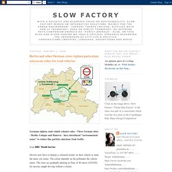
Other German cities - but not all - plan to have such zones later in 2008. The stickers - green, red or yellow - are mandatory not only for locals but also for foreign drivers, INCLUDING TOURISTS.There is a one-off charge of five to 10 euros for the stickers, issued by Germany's vehicle registration authority and authorised garages. Some hotel and restaurant owners have voiced fears that tourists will be put off by the requirement for stickers, reports in Germany say.

NOTE that the German scheme is not following an earlier congestion charge of any sort. Advierten que se debe dejar de usar el auto en las ciudades. El arquitecto de las personas. Tags: BicicletasCities for PeopleCiudadesJan GehlUrbanismo “Sabemos más sobre el hábitat del oso panda que del ser humano”. Jan Gehl está cansado de ver cómo la planificación urbana pasa por alto al ser humano. “Los arquitectos y los planificadores de ciudades viven desconectados de las personas. Se proyectan enormes edificios que miran al cielo y se añaden más carriles para los coches, pero se olvidan completamente de lo que ocurre en el suelo. Ese espacio donde los humanos se mueven, viven e interactúan”. Este urbanista y arquitecto danés de 74 años es uno de los grandes artífices del Copenhague actual, donde más del 37% de la población utiliza la bicicleta como principal medio de transporte (el objetivo es que supere el 50% en los próximos años). Pero a pesar de que las teorías de Gehl tienen un sentido común aplastante, implantar una visión más humanista en la planificación de ciudades requiere deshacer medio siglo de ideología modernista.

El humano es un animal que camina. How a planned highway can change a city, even if it never gets built. (1) - By Tom Vanderbilt. I-478 is a pretty remarkable road: It is, for one thing, the longest tunnel on the U.S. Interstate Highway System. It's also the longest subaqueous facility. But I-478 conceals its charms; driving on it, there is nothing—not a single red, white, and blue shield—to tell you that you are doing so. This shy and retiring facility is the Brooklyn Battery Tunnel, connecting Brooklyn to Lower Manhattan. While it appears on maps, I-478 is not signposted (to avoid driver confusion with Brooklyn's nearby I-278, the story goes), and virtually never referred to by its federal designation.

I-478 is something of a phantom highway, and if you head north to the Manhattan Bridge, you can find a clue as to its origins: a bit of hanging roadbed in the median that simply comes to an end. The Lower Manhattan Expressway—dubbed "Lomex"—which would have coursed in eight-lane glory through the now-vibrant (and expensive) neighborhoods of Soho and Nolita, is one of the world's most famous unbuilt highways. Proyecto urbano: ciudades norteamericanas planean reemplazar autopistas por espacios recreativos. Vía 8664org. Propuesta para el waterfront de Louisville Solemos creer, y es efectivo, que una ciudad que quiere desarrollarse y crecer necesita autopistas: varias, rápidas y bien planificadas. Pero en siete ciudades norteamericanas están pensando precisamente lo contrario: echar abajo las carreteras, en su mayoría costeras, para dejar lugar a la edificación de casas y la habilitación de zonas de recreación.

El motivo principal es que es costoso mantener las autopistas, no se obtienen suficientes ganancias por su uso y se pueden vender los terrenos para el desarrollo inmobiliario. Después del salto, conoce en qué ciudades y cómo planean implementarse estos proyectos urbanos. Algunas son autopistas que están llegando al fin de su vida útil, pero en vez de arreglarlas se pretende simplemente echarlas abajo. El caso de la autopista Park Freeway en Milwaukee muestra que los resultados de decidir demoler las autopistas son inciertos.

Vía carfreeinbigd.com. Vía downtowncrossingnewhaven.com. Long commutes cause obesity, neck pain, loneliness, divorce, stress, and insomnia. - By Annie Lowrey. This week, researchers at Umea University in Sweden released a startling finding: Couples in which one partner commutes for longer than 45 minutes are 40 percent likelier to divorce. The Swedes could not say why. Perhaps long-distance commuters tend to be poorer or less educated, both conditions that make divorce more common. Perhaps long transit times exacerbate corrosive marital inequalities, with one partner overburdened by child care and the other overburdened by work. But perhaps the Swedes are just telling us something we all already know, which is that commuting is bad for you.

Annie Lowrey, formerly Slate’s Moneybox columnist, is economic policy reporter for the New York Times. Commuting is a migraine-inducing life-suck—a mundane task about as pleasurable as assembling flat-pack furniture or getting your license renewed, and you have to do it every day. First, the research proves the most obvious point: We dislike commuting itself, finding it unpleasant and stressful. Does Driving Cause Obesity?

The Checkup - Traffic noise boosts stroke risk. Can traffic noise be deadly? Well, not quite. But a new study indicates that chronic exposure to noise from cars and trucks can boost the risk for stroke, especially among the elderly. Mette Sørensen, senior researcher at the Institute of Cancer Epidemiology, Danish Cancer Society in Copenhagen, Denmark, and colleagues studied 51,485 people in the Copenhagen and Aarhus areas between 1993 and 1997. For every 10 decibels of noise, the stroke risk increased by 4 percent, they found. But when the Danish researchers parsed the data more closely, they found that there was no statistically significant increased risk of stroke for people younger than 65.

But the risk increased by 27 percent for every 10 decibels higher road traffic noise in those age 65 years and older. The researchers took other factors into consideration that could confuse the findings, such as exposure to air pollution from exhaust and other related noise. Autism: Proximity to freeways increases autism risk, study finds - latimes.com. Children born to mothers who live close to freeways have twice the risk of autism, researchers reported Thursday. The study, its authors say, adds to evidence suggesting that certain environmental exposures could play a role in causing the disorder in some children. "This study isn't saying exposure to air pollution or exposure to traffic causes autism," said Heather Volk, lead author of the paper and a researcher at the Saban Research Institute of Children's Hospital Los Angeles.

"But it could be one of the factors that are contributing to its increase. " Reported cases of autism cases increased by 57% between 2002 and 2006, according to the Centers for Disease Control and Prevention, although professionals still debate whether rates have actually risen or a greater proportion of autistic children is being diagnosed. An estimated 1 in 110 children is diagnosed with autism today. Each family was evaluated in person, and all of the children received developmental assessments. Transport.