
The Reykjavík Grapevine Online - Daily News from Reykjavík, Icel. HIKING TREKKING TRAIL LANDMANNALAUGAR THORSMORK LAUGAVEGUR, HIKI. The total hiking distance is close to 53 km and the route from Thorsmork to Skogar on the south coast adds 24-26 km.
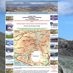
The Landmannalaugar - Thorsmork route is called „Laugavegurinn", The Hot Spring Route, which is very appropriate. It is clearly marked between the huts in Landmannalaugar, Hrafntinnusker (Obsidian Skerry), on lake Alftavatn (The Lake of the Whooper Swans) and on river Sydri-Emstrua in Fremri-Botnar. The trail "Laugavegurinn" is one of the most popular and most travelled hiking trails in Icelandic wilderness. Road conditions and weather < English < Stoðval < Hliða. Information on road conditions is entered from 7:00 - 22:00 and are displayed here almost immediately.

Outside these hours, information remains unchanged and is erased at some point after midnight. Weather information comes from automatic weather stations and is therefore updated on a 24-hour basis. Weather forecasts can be found at the Icelandic Meteorological Office homepage. [ The entire country | South Iceland | South-West Iceland | West Iceland | The Western fjords | North Iceland North-East Iceland | East Iceland | South-East Iceland ] A map showing road conditions in different regions may be obtained by clicking on the appropriate place on the map of Iceland above; a map of the entire country can be had by clicking on the center of the map.