
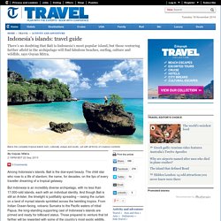
Bluepueblo: Rainforest Canopy Walkway, Borneo ... Indonesia's islands: travel guide. An island of Hindu offerings, incense wafts through the air from the second you step off the plane, and colourful, eccentric-looking gods poke their head out of every taxi mirror, shop door and hotel lobby.
Most visitors focus their stay on the southern shores – Seminyak for couples seeking luxury, and Kuta for raucous merriment and markets. These well-trodden, southern beaches are vast, yawning swathes of surf-crashed sand, alive with neon-hued après-surf nightclubs. The party crowd is easy to avoid, however. Escapists make for the hidden coves of Bingin, where fierce waves have carved out a parade of cliff-skirted, white sand coves, with frothy shallows created by peeling barrels of surf on the horizon. Things get wild on the tempestuous northern shore as inky black volcanic sands line the coast at beaches such as Lovina.
Where to stay Bali Uma Ubud (00 62 361 972448; comohotels.com/umaubud). Nusa Bay Resort (00 62 361 484085). Bali in pictures. Grotte di Tailandia. The Mitchell Falls And Mitchell Plateau. Are among the most photographed attractions of the Kimberley. I took the shots you see on this and other pages while I was up there in May 2006. We had had a fabulous wet season so I was lucky to see the falls at their most splendid. But trust me, . It's not just the Mitchell Falls that make it special, there is so much to discover and do here. And that's what this part of the site is about. You can see the falls by taking a scenic flight from Drysdale Station on the Gibb River Road. Yes, getting to the Mitchell Plateau takes some time and dedication, but it's worth it! Here's all you need to know to plan your trip! About the Mitchell River National Park : Background Information (history and ecology).
The Mitchell Plateau : Visitor Information (getting there, camping, scenic flights). Some photos of the Mitchell Plateau Track . The hike to the Mitchell Falls . Pictures from the Mitchell Plateau . Do You Belong To The Lucky People Who Could Make Time For This Trip? It's easy! Thank ... Return to top. Blaxland Riverside Park - Sydney, Australia.
JMD Design of Redfern, Sydney has created a cool kids’ outdoor space that makes us all want to run free and wild, with our hair blowing happily in the wind and our bodies full of positive energy.
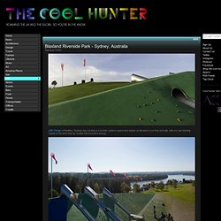
The 20,500 square meter park, opened this summer, is located at Jamieson and Homebush Streets, in Sydney, Australia, and operates under the Sydney Olympic Park Authority. JMD Design wanted to avoid the fenced-in, overly structure-based approach of many kids’ outdoor parks. They worked with, rather than against the earth forms of cones, cuts and terraces, established earlier at this site, and created a free-flowing, open play area with surprises and distinctive activity points.
The tree house is manufactured from galvanised steel, fibrous cement sheeting floors and walls, hardwood timber batten walls and ceilings, stainless steel mesh walls and ceilings with rope floors in some areas. Ubud Hanging Gardens Luxury Hotel & Spa Resort in Bali, Indonesia. Taal Lake. Taal Lake is a freshwater lake in the province of Batangas, on the island of Luzon in the Philippines.
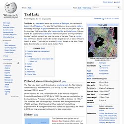
The lake fills Taal Caldera, a large volcanic caldera formed by very large eruptions between 500,000 and 100,000 years ago. It is the country's third largest lake after Laguna de Bay and Lake Lanao. Volcano Island, the location of Taal Volcano's historical eruptions and responsible for the lake's sulfuric content, lies near the center of the lake. There is a crater lake on Volcano Island, which is the world's largest lake on an island (Volcano Island) in a lake (Taal Lake) on an island (Luzon). Known as the Main Crater Lake, it contains its own small island, Vulcan Point. Protected area and management[edit] The Taal Lake basin was first declared as a national park, the Taal Volcano National Park, by Proclamation no. 235 on July 22, 1967 covering 62,292 hectares (153,930 acres).[2] History[edit] Taal Lake was once just an arm of Balayan Bay. Ecology[edit] Fish kill[edit] Isole Samoa. Da Wikipedia, l'enciclopedia libera.
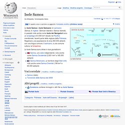
Le Isole Samoa Le Isole Samoa o Isole Samoane (in samoano: Samoa, in inglese: Samoan Islands o Samoa Islands), in passato note anche come Isole dei Navigatori sono un arcipelago di 3.030 km² situato nel Pacifico meridionale, facenti parte della regione della Polinesia. Registrano una popolazione di circa 250.000 abitanti, con una lingua comune, il samoano, e una comune cultura, la fa'asamoa. Le Isole Samoa sono divise in due giurisdizioni: Samoa, uno stato indipendente, noto anche come Samoa Occidentali (2.831 km² e 185.000 abitanti) Samoa Americane, un territorio degli Stati Uniti, noto anche come Samoa Orientali (199 km² e 65.000 abitanti) Voci correlate[modifica | modifica sorgente] Altri progetti[modifica | modifica sorgente] Commons contiene immagini o altri file su Isole Samoa.