
Skip to main content Menu Search Official State Vacation Guide & Map Request Form Planning your Colorado vacation is even easier with a Free Official State Vacation Guide, Official State Map, Virtual Byway Guide and Colorado eNewsletter.

To place a bulk order for official vacation information, please visit Colorado.com/Request-Bulk-Travel-Resources. View the International Holiday Guide in English, Español, Deutsch, Français or 日本語. Travel Guides Other Items You May Be Interested In Enter Your Details If your country is not listed, we do not mail to that country. When you submit your Visitors Guide Request, you will receive an email message confirming our receipt of your order. You may also request this information via telephone by calling 1-800-COLORADO.COLORADO.COM will not share your information with any other organizations.Click here to review our privacy policy.
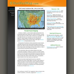
Hazard Maps, News, & Resources - Tornado. USA Tornado Touchdowns Map - click on lower right Tornado Hazard Mapping A tornado, or "twister", is a storm-induced rapidly rotating column of air and associated debris which extends from a cloud to the ground.

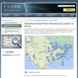
A tornado which touch down over a body of water is referred to as a waterspout. Due to the high winds that occur, tornadoes can cause injury, death and significant property damage. Tornadoes only occur during specific atmospheric conditions, which can be the result of other types of weather such as hurricanes or strong thunderstorm activity. During periods of thunderstorm activity and potential tornado formation, map based forecasts are used to issue tornado warnings and watches for specific areas. In the United States, NOAA and the National Weather service issue warnings when atmospheric conditions are conducive to tornado formation. To learn more about tornado hazards in your area, contact the appropriate local, state or federal agency. Operating Nuclear Power Reactors (by Location or Name) A power reactor is a facility that makes electricity by the continuous splitting of uranium atoms (i.e., a nuclear reaction).

This facility is often referred to as a nuclear power plant. To find information about a particular operating nuclear power reactor that NRC regulates, select that reactor from the map below, or from the Alphabetical List of Operating Nuclear Power Reactors by Name. Map Data Map data ©2014 Google, INEGI Note: Region IV oversees the Grand Gulf plant in Mississippi (MS), which is part of Region II. Where The Buffalo Roamed – How Far Can You Get From McDonald's? This summer, cruising down the I-5 through California’s Central Valley to the Los Angeles Basin, I unwittingly stumbled upon a most exasperating development: the country strip mall.

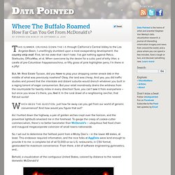
First, let me state that I don’t hate. I’ve got nothing against Petco, Starbucks, OfficeMax, et al. When overcome by the desire for a cubic yard of kitty litter, a carafe of pre-Columbian frappasmoochino, or fifty gross of pink highlighter pens, I’m there in a jiffy! But, Mr. Real Estate Tycoon, did you have to plop your shopping center smack dab in the middle of what was previously nowhere? Which begs the question: just how far away can you get from our world of generic convenience? As I hurtled down the highway, a pair of golden arches crept over the horizon, and the proverbial lightbulb smacked me in the forehead. So, I set out to determine the farthest point from a Micky Dee’s – in the lower 48 states, at least. The contiguous United States visualized by the distance to the nearest McDonald's. Tar Sands: When This Oil Spills, It's 'A Whole New Monster' Whistle-blower John Bolenbaugh wades through thick mud in the Kalamazoo River looking for leftover traces of oil from the July 2010 Enbridge tar sands pipeline spill.

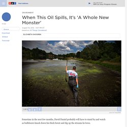
John W. Poole/NPR An oil sheen appears along the shore of the Kalamazoo. More than 800,000 gallons of oil entered Talmadge Creek and flowed into the Kalamazoo River, a Lake Michigan tributary. Heavy rains caused the river to overtop existing dams and carried oil 30 miles downstream. John W. Children fish at a newly opened recreational area built by Enbridge on the Kalamazoo River. Sometime in the next few months, David Daniel probably will have to stand by and watch as bulldozers knock down his thick forest and dig up the streams he loves.
His East Texas property is one of more than 1,000 in the path of a new pipeline, the southern stretch of what is known as the Keystone XL system. For years, Daniel has tried to avoid this fate — or at least figure out what risks will come with it. This is not conventional crude.