
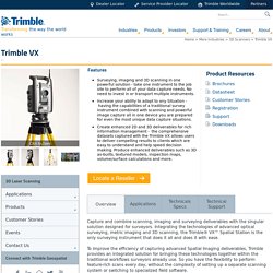
Lidar. Scanner tridimensionnel. Un article de Wikipédia, l'encyclopédie libre.
Un scanner tridimensionnel est un appareil de numérisation et d'acquisition 3D. Diverses technologies peuvent être utilisées dans la numérisation d'objet en image 3D ; chacune a ses limites, avantages et coûts. Certains types d'objets restent toutefois encore difficile à numériser : par exemple les appareils utilisant des technologies optiques rencontrent beaucoup de difficultés avec des objets brillants, miroitants ou transparents. Il existe cependant des méthodes permettant de scanner les objets brillants, par exemple en les recouvrant d'une fine couche de poudre blanche qui permettra à plus de photon de se réfléchir et de parvenir à l'optique du scanner.
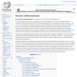
Les scanners laser peuvent envoyer des trillions de photons vers un objet et en retour recevoir un petit pourcentage de ces photons par les optiques qu'il utilise. Principe[modifier | modifier le code] Des analogies existent entre un appareil photo et un scanner 3D. Leica Nova MS50 - MS50 MultiStation – The new dimension in measuring technology - Leica Geosystems. Trimble VX. Capture and combine scanning, imaging and surveying deliverables with the singular solution designed for surveyors.
Integrating the technologies of advanced optical surveying, metric imaging and 3D scanning, the Trimble® VX™ Spatial Station is the only surveying instrument that does it all and does it with ease. To improve the efficiency of capturing advanced Spatial Imaging deliverables, Trimble provides an integrated solution for bringing these technologies together within the traditional workflows surveyors already use. So you have the flexibility to perform feature-rich scans every day, without the complexity of setting up a separate scanning system or switching to specialized field software.
Video-Assisted Control Trimble VISION™ gives you the power to see everything the instrument sees. Direct your work with live video images on the controller Now you are free to capture measurements to prism or reflectorless surface with a point and click. Solution Center Technical Support. Topcon Positioning Systems, Inc. Land Mobile Solutions. Topcon Positioning Systems, Inc. Topcon’s GLS-1500 laser scanner leaves nothing behind—except the competition.
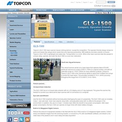
The operator-friendly design allows for quick and hassle-free setups which saves time and improves productivity. With batteries and data collector on-board, Topcon’s GLS-1500 is lightweight and cable-free. Transportation is a cinch. While other laser scanners take two people to unload, setup, operate, and load, the GLS-1500 is a one-man instrument.
Feature packed... On-board Data Collection The GLS-1500 has an on-board data collector with an LCD display and a 21-key keyboard. Eye-safe and Efficient Use the GLS-1500 anywhere without worrying about damaging the eyes of a passersby. Built-in 2.0 Megapixel Digital Camera Reduce the amount of equipment needed in the field with the GLS-1500’s built-in 2.0 megapixel digital camera. GLS-1500 features also include: GeoMax provides a comprehensive portfolio of integrated instruments for the surveying, mapping and construction industries. RIEGL - Terrestrial Scanning. Leica ScanStation P15 - Enter the world of precise laser scanning - Leica Geosystems. Scanner laser 3D - Aperçu - FARO Focus3D. Les derniers scanners laser FocusS 150 et 350 de FARO® vous permettent de mesurer précisément des objets et bâtiments complexes de manière simple et rapide.
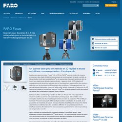
La taille de l’écran tactile intuitif des modèles FocusS a été augmentée et sa clarté améliorée afin de fournir une expérience utilisateur extraordinaire. L’appareil photo HDR intégré de 8 mégapixels prend des photos précises tout en fournissant une superposition des couleurs naturelle pour les données numérisées dans des conditions d’éclairage extrêmes. Les caractéristiques habituelles, comme le faible poids, la taille compacte et l’autonomie de 4,5 heures de la batterie, font du laser scanner FocusS un véritable appareil mobile permettant de réaliser des numérisations rapides, sûres et fiables. Le FocusS 350 a une très longue portée de 350 m, le FocusS 150 est un appareil de moyenne portée qui permet une numérisation précise jusqu’à 150 m.
Tous les types de scanners permettent d’effectuer des relevés en plein soleil. VIAMETRIS - Solutions de Cartographie Mobile.