
LinkIt ONE Smart Vehicle Box(SVB) Introduction Have you ever thought of turning on Air Conditioner/Heater of your car before 10mins you get in.
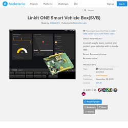
Here in my country (India), hot sun may toast your car in parking area during day time. A system that can turn on/off engine ignition and Air Conditioner from your smart phone would be a solution for this issue. This system can also protect you from the threat of theft by providing real time tracking options and SMS alerts (you need to add just 2 lines of program). Along with these smart options some extended options like remote Lock/Unlock, On/Off alarm or head light, etc. are also incorporated. Overall System Arrangement Smart Vehicle Box Smart Vehicle Box consists of 4 major units.
Carte des radars en France. Radar_fr. Map Viewer (QML) This is a large example covering many basic uses of maps, positioning, and navigation services in Qt Location.
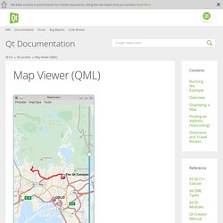
This page is divided into sections covering each of these areas of functionality with snippets from the code. Running the Example To run the example from Qt Creator, open the Welcome mode and select the example from Examples. For more information, visit Building and Running an Example. The example can work with any of the available geo services plugins. --plugin. Refer to the documentation for each of the geo services plugins for details on what plugin parameters they support.
Overview. Part 2b – Utilizing GPS Data: Tutorials – Sandblog. So you’ve gone out in the field and collected some data, what do you do now?
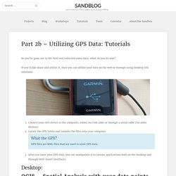
If you’d like share and utilize it, then you can utilize your data on the web or through using desktop GIS solutions. Connect your GPS device to the computer, either via USB cable or through a serial cable (for older devices)Locate the GPX folder and transfer the files onto your computerWhat the GPX? GPX files are XML files that are used to store GPS data.After you have your GPX data, you can manipulate it in various applications both on the Desktop and through Web-based interfaces. Part 1: Check to see if GPS tools are enabled Go to Plugins -> Manage and Install Plugins… and search for “GPS tools” Tick the check box to ensure that the plugin is installed. Part 2 – Spatial Analysis, QGIS, and GPS. GPS Module, Python & Google maps all in one – HELENTRONICA. Introduction For the first post on my blog I decided to publish some project I had done in my spare time few months ago.
Global Positioning System, satellites, navigation, you know it, you used it probably. Nick's Code. S60 Python GPS Info Viewer (NMEA Bluetooth and S60 Location) (graphical) (v0.28) GPL (blog post) A graphical python program that talks to your gps, and does useful things with the information.
It is able to talk to a bluetooth GPS (parsing the nmea data strea), or on S60 v3 phones with the LocationRequestor module, an internal GPS.The program displays your current location, speed and heading, satellites in view, satellite signal strength, the time, distance and direction to a point, and more. It optionally also dumps positions to a file, which you can later get off to see where you went (see upload_track). It can take photos, and add the Geo Exif headers to tell you where you were when you took it (requires PExif). Which gps library would you recommend for python? Python and GPS Tracking. Python and GPS Tracking Skill Level: Advanced by a1ronzo | December 17, 2012 | 17 comments Introduction In my quest to design a radio tracking system for my next HAB, I found it very easy to create applications on my computer and interact with embedded hardware over a serial port using the Python programming language.
BaseCamp™ Planification d'un voyage Utilisez le logiciel BaseCamp pour planifier votre prochaine randonnée à pied ou à vélo, votre prochain voyage à moto ou en voiture, ou votre prochaine excursion hors route.
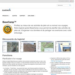
Vous pouvez afficher des cartes, planifier des itinéraires, et marquer des waypoints et des tracés sur votre ordinateur, puis les transférer sur votre appareil. La fonction « Track Draw » vous permet de tracer votre itinéraire planifié et d'afficher les dénivelés, afin de vous aider à mieux évaluer la difficulté de votre parcours à pied ou à vélo.
Planifiez le meilleur itinéraire touristique pour votre prochain voyage en voiture, en demandant à votre navigateur de passer par certains waypoints. Documentation Mapnik — Mapnik v1.0.0 documentation. Nzjrs/osm-gps-map @ GitHub. A Gtk+ Widget for Displaying OpenStreetMap tiles.
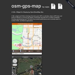
A Gtk+ widget (and Python bindings) that when given GPS co-ordinates, draws a GPS track, and points of interest on a moving map display. Downloads map data from a number of websites, including openstreetmap.org. The library has excellent performance and is currently used in a number of Gtk+ and Maemo applications. Currently supports a number of different mapping sources openstreetmap (default) maps-for-free satellite maps from a number of proprietary providers It also has the following features. Introduction. Ce document est à la fois un tutoriel et un guide de référence.
Il ne liste pas tous les cas d’utilisation possibles, mais donne une bonne idée générale des principales fonctionnalités. Dès la version 0.9, QGIS intégrait un support optionnel pour le langage Python. Osmapi. This documentation is about a python class to communicate with OpenStreetMap API v0.6 developped by User:EtienneChove (currently maintained by User:Metaodi).
Please submit an issue if you require other features. Hello World : node download Documentation The documentation is available online: Examples. Kosmtik/kosmtik: Make maps with OpenStreetMap and Mapnik. Python + Leaflet = Folium, ou comment créer des cartes interactives simplement. Vous voulez visualiser directement les résultats de vos traitements Python sur une carte interactive avec Leaflet, alors adoptez Folium de wrobstory (Python 2.7.x, mais il est possible de le faire fonctionner en Python 2.6.x moyennant quelques petites modifications dans les scripts).
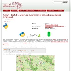
Le module a déjà été rapidement présenté dans la revue de presse du 24 mai 2013 de GeoTribu (Folium : Python et Leaflet sont dans un bateau). Il utilise les librairies JavaScript Leaflet.js et d3js pour fournir le résultat. Tutorial: Freedom Board with Adafruit Ultimate GPS Data Logger Shield. Many times I start with a project and tutorial, only to get interrupted for emergency tasks and assignments. For a long time I wanted to add GPS (Global Positioning System) functionality to one of my projects. While I started a few months ago on this, it took me until this week-end to finish the at least the first part: a SD card data logger with GPS :-): I calculate global positioning and time information, can use it in Google maps and store it on a SD card:
Ultimate GPS! Tutorial: Freedom Board with Adafruit Ultimate GPS Data Logger Shield. GitHub - python-visualization/folium: Python Data. Leaflet.js Maps. Python + Leaflet = Folium, ou comment créer des cartes interactives simplement. Python + Leaflet = Folium, ou comment créer des cartes interactives simplement. Chart Maps. Mapnik.org - the core of geospatial visualization & processing.
Design and publish beautiful maps. Map Your World's Data. Stamen. Stamen. MapQuest Maps - Driving Directions - Map. Kosmtik/kosmtik: Make maps with OpenStreetMap and Mapnik. Design and publish beautiful maps.
Downloads. Latest Release The latest release is Mapnik v3.0.9. Mapnik 3.0.9 Release Date: 26 November 2015 Prebuilt Binaries.