
Piri Reis. Un article de Wikipédia, l'encyclopédie libre.
Piri Ibn Haji Mehmed dit Piri Reis était un grand amiral ("reis" en turc) de la flotte ottomane au XVIe siècle, né à Karaman (province). Neveu du célèbre pirate Kemal Reis dit Camali, il est surtout connu pour son œuvre de cartographe. Lettré, il se passionnait pour les cartes et les collectionnait. Cartographie[modifier | modifier le code] En 1513 et en 1528, il dessina deux cartes du monde, reprenant les cartes et les données de sa collection dont certaines remonteraient à l'antiquité. Une des cartes les plus célèbres est celle surnommée Carte de Piri Reis. Amiral de la flotte d'Égypte[modifier | modifier le code] En 1547, après un long oubli, Piri Reis est fait amiral de la flotte d'Égypte basée à Suez qui opère dans la mer Rouge, dans l'océan Indien et dans le golfe Persique Prise d'Aden[modifier | modifier le code] Départ pour Ormuz et prise de Muscate[modifier | modifier le code] Notes et références[modifier | modifier le code]
Piri Reis - Wikipedia, l'encyclopédie libre. Piri Reis (Turkish: Pîrî Reis or Muhyiddin Pîrî Bey also known as Hacı Ahmed Muhiddin Piri; "Reis" being a military rank) was an Ottoman admiral, geographer, and cartographer born between 1465 and 1470.
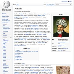
He was executed in 1553.[1] He is primarily known today for his maps and charts collected in his Kitab-ı Bahriye (Book of Navigation), a book that contains detailed information on navigation, as well as very accurate charts (for their time) describing the important ports and cities of the Mediterranean Sea. He gained fame as a cartographer when a small part of his first world map (prepared in 1513) was discovered in 1929 at the Topkapı Palace in Istanbul. His world map is the oldest known Turkish atlas showing the New World, and one of the oldest maps of America still in existence anywhere (the oldest known map of America that is still in existence is the map drawn by Juan de la Cosa in 1500). Piri Reis' map is centered on the Sahara at the latitude of the Tropic of Cancer.[2] Saudi Aramco Monde: Piri Reis et la carte Columbus. Piri Reis and the Columbus Map Written by Paul Lunde In 1501 an admiral in the Ottoman navy named Kemal Reis captured seven Spanish ships off the coast of Spain, near Valencia.
Aboard one of the prizes he found a strange feather headdress and an unfamiliar black stone. He was told by one of his prisoners that both came from newly discovered lands to the west, beyond the Sea of Darkness. The prisoner claimed to have visited these lands three times, under the command of a man named Colombo - and what was more, he had in his possession a chart, drawn by this man Colombo himself, that showed the newly discovered lands. This was probably not the first time Kemal Reis had heard of Christopher Columbus's discovery. Between 1492 and 1501, while Columbus was making his first three voyages, the Ottoman sultan Bayazid II was occupied on all fronts.
Columbus's discoveries in the Atlantic, however, were very remote from Ottoman interests. Good friend, I want you To remember us in your prayers, Pin Piri Reis Dans Haritası sur Pinterest.