
Explicit cookie consent. RICHARD GOLDTHWAITE has served a long apprenticeship.

As a dedicated student of the economy of Florence between the 13th and 16th centuries, he has published studies of the city's buildings and banks, its private wealth and the demand for its art. Now he has stood back and produced a magisterial history which brings all the strands of the story together and becomes, among its other virtues, a persuasive account of early capitalism.
Florence became one of medieval and Renaissance Europe's great industrial cities. Its principal resource was the river, the fast-flowing Arno, which provided power and water for industry and access to the sea for imports and exports. Evans, Allan/ Francesco Balducci Pegolotti, La Pratica della Mercatura. Edited by ALLAN EVANS. Medieval Academy Books, No. 24 (1936).
Archaeology in Europe - Early Medieval Emporia: Sceattas. Booming Shipping Network. Urban Demographics. Civilization Past & Present - Illustrations. The growth of trade and cities during the period from 1000 to 1300 in France and the Low Countries and the continued dominance of the northern Italian cities reflected the emerging vitality of Europe during the High Middle Ages.

Rotterdam - a shipping port. Updated: Colonial Shipping Routes. History of Macau. Port Towns and Urban CulturesPort Towns and Urban Cultures. Gerard vd Ven Nieuwe Waterweg en Noordzeekanaal.pdf. Port of Rotterdam - History of the port. Toekomst van de haven, de haven van de toekomst. 18th Century shipping mapped using 21st Century technology. Last month we looked at an example of an old mapping style being applied to modern data.
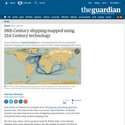
This time it's the other way round. James Cheshire, of Spatial Analysis, has taken historical records of shipping routes between 1750 and 1800 and plotted them using modern mapping tools. The first map, above, shows journeys made by British ships. Cross-Atlantic shipping lanes were among the busiest, but the number of vessels traveling to what was than called the East Indies - now India and South-East Asia - also stands out when compared to Dutch and Spanish records (see below).
If you look carefully you can also make out Captain Cook's voyages, including his two global circumnavigations.