
Earthmate GPS PN-60 with Topo North America 9.0 - DeLorme. Earthmate PN-60 GPS Details Key Features: » 3.5 GB of internal flash memory » Intuitive icon-based user interface for easy on-device navigation » Elevation profile cutaway views that pinpoint the user's position » GPX support for improved waypoint, track, and geocache file management › No finite limitations on the quantities of each that can be saved to internal memory › In addition, all can be saved to and retrieved from SD cards › Tracks can now hold 20,000 points (versus 10,000 with earlier PN-Series models); you can edit track settings to automatically save the active track and start another (upon hitting 20,000 points); overwrite the existing track points (oldest first); or stop track recording entirely › Waypoints/geocaches - save 1500 per file to internal memory, no maximum limit on the number of files » Latest DeLorme power management system with ambient light sensor for optimal battery life » Holds 100 routes (compared to 50 with earlier PN-Series models)

For ESRI Users - DeLorme. Load Google Maps Into Quantum GIS. You can load Google Maps into Quantum GIS (QGIS) using OpenLayers Plugin for QGIS.

This plugin is developed by Luiz Motta and allows loading application QGIS spatial data from Google Maps, also from Yahoo Maps and OpenStreetMap. With this plugin OpenLayers Plugin for QGIS, whenever a user to zoom in / out in QGIS browser, Google Maps on dockable window (called OpenLayer Overview) will adjust the same location as the display QGIS browser.
User can save the Google Maps image from OpenLayer Overview as a jpg file and copy rectangle of map to paste into Google Earth as layer (kml file). OpenLayers Plugin for QGIS can be installed either in the application direct QGIS using the command Fetch Python Plugins or can be downloaded here. Libya. Libya GIS Adviser - Lynx Information Systems. Lynx has released (Q4 2009) a new, GIS-enabled Petroleum Systems Analysis of the Sirt Basin, authored by David Boote of DB Consulting, a recognised expert in North African geology.

This major, integrated study provides a regional petroleum systems framework for: play analysis and risking prospect highgrading/ranking and risking extending existing play trends and developing to play concepts/ideas The report contains a comprehensive series of regional facies maps supported by: basin-wide stratigraphic correlations detailed stratigraphic sections illustrating local stratigraphic architecture a regional analysis of oils, identification of key oil families and provisional oil-to-source correlations basin-wide burial history reconstructions regional generative area expulsion / migration models 1/10 The study draws upon an extensive inventory of interpreted maps, well and seismic data, including 3000+ wells with tops and 1000+ with wireline data.
Libya GIS Adviser - Lynx Information Systems. Lynx has released (Q4 2009) a new, GIS-enabled Petroleum Systems Analysis of the Sirt Basin, authored by David Boote of DB Consulting, a recognised expert in North African geology.

This major, integrated study provides a regional petroleum systems framework for: play analysis and risking prospect highgrading/ranking and risking extending existing play trends and developing to play concepts/ideas The report contains a comprehensive series of regional facies maps supported by: North Africa GeoNet: GIS. WikiProject Libya. Libya is a country in Africa at latitude 27° 0′ 0″ North, longitude 17° 0′ 0″ East.

Libya is a country located in North Africa, between Egypt (on the east) and Tunisia / Algeria (west). Libya has a population of approximately 6 million, concentrated along the Mediterranean coast in the north of Libya. Largest cities include Tripoli and Benghazi. With the current uprising and humanitarian crisis in Libya, the Humanitarian OpenStreetMap Team "HOT" is coordinating efforts to improve OSM's coverage of Libya, and needs volunteers to help. "OCHA, UNOSAT and NetHope have been collaborating with the Volunteer Technical Community (VTC) specifically including the CrisisMappers, Crisis Commons, Open Street Map" [...more].
The OpenStreetMap community can assist the response by tracing various satellite imagery and other data sources, and collecting existing data sets below. The security and ethics of live mapping in repressive regimes and hostile environments. OpenStreetMap Extracts for Libya. Index of /africa/libya. Walking Papers. Downloads. Connecting via USB. OSM Map On Garmin. Available languages — Garmin Colorado 300 showing routable OSM made with mkgmap Many Garmin GPS devices can show maps on their display.
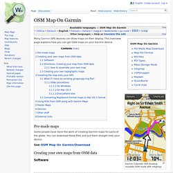
This overview page explains how you can get OSM maps on your Garmin device. Pre-made maps Some people have done the work of creating Garmin maps for parts of the globe. See OSM Map On Garmin/Download Creating your own maps from OSM data Software Mkgmap is an Open Source Java program developed specifically for converting OSM data into Garmin map image files. Directions: Creating your map from OSM data These are generally the steps involved (also see the Software section above): Get OSM data: The easiest way of all is to use the Export tab on the site.
If you are interested on building the map for a single country on a windows machine, User:GPS-Marco provides a software package collecting all the needed tools and a script that executes all the above steps with a simple double click. How to assemble your own map. MxGPS: Download and upload data using Garmin GPS from within ArcGIS. The following items are currently available for download: This is a new version and registration will require a new product key If you are a registered user and require the upgrade link please email a request including your existing registration details.

Previous versions are also available for download. New Version: MxGPS has been redeveloped to run on the Microsoft .Net Framework.