
SimonWillis.net: New Sea Kayak Map to Scotland's West Coast. A double-sided map covering covering part of Scotland's prime sea kayaking area is now on sale.
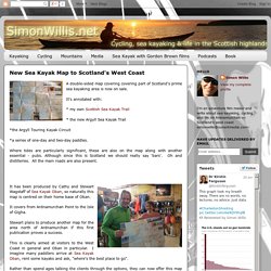
It's annotated with: * my own Scottish Sea Kayak Trail * the new Argyll Sea Kayak Trail *the Argyll Touring Kayak Circuit *a series of one-day and two-day paddles. Where tides are particularly significant, these are also on the map along with another essential - pubs. It has been produced by Cathy and Stewart Wagstaff of Sea Kayak Oban, so naturally this map is centred on their home base of Oban. It covers from Ardnamurchan Point to the Isle of Gigha. Stewart plans to produce another map for the area north of Ardnamurchan if this first publication proves a success. This is clearly aimed at visitors to the West Coast in general and Oban in particular. Rather than spend ages talking the clients through the options, they can now offer this map (ideally in advance) to plan their trip.
At £6.95 in the shop or £8.15 online. For example, there are none on Mull; in Loch Sunart; off Islay. Canoe and Kayak news, reviews, tips, photos and videos. #1 St Govans Head One of the most impressive and varied trips along the Welsh coastline.

Continual cliffs yield few places to get out until the safety of Broad Haven, and overfalls, surf beaches, caves and a firing range make this a challenging trip to plan. #2 Dwyryd Estuary In the north-east corner of Cardigan Bay, this is a good introductory paddle which can be taken to its tidal limit at Maentwrog, passing the ornate village of Portmeirion and the slate quays, before entering the Vale of Ffestiniog. A hasty return is necessary so as not to become beached on sandbanks – the estuary dries quickly. . #3 Conwy Estuary The lower reaches of the Conwy display varied and beautiful scenery, historic monuments, Sites of Special Scientific Interest and spectacular views of the Carneddau mountains of northern Snowdonia. . #4 Arisaig This area is the nearest you will get to paddling in the Caribbean when in Scotland. . #5 Summer Isles This area is a sea kayaker’s paradise.
. #6 Terfor to Porth Dinllaen. Scottish Canoe Association. The Spey is a major river that can usually be relied upon to give reasonable water levels at all seasons.
Probably one of the most beautiful rivers in Britain, flowing past the Cairngorms, through Badenoch and Strathspey and into the Moray Firth at Spey Bay. Whilst, before venturing on to the Spey unguided one should be a proficient paddler, there are very few highly technical rapids on the river. On sections downstream of Grantown-on-Spey there is a good number of entertaining Grade II rapids. Truly a ‘water-path’, this river is navigable for most of its length ~ from source at Loch Spey (where the Spey shares its water shed with the turbulent River Roy). A major hazard occurring above Laggan Bridge is the Spey Dam, which like the River Roy steals the Spey's waters and takes them westward (to help power an aluminium smelter). Access The River Canoeists can start a scenic, leisurely paddle from opposite the campsite at Spey Bridge just above Newtonmore.
Weather and Climate: Edinburgh, Scotland, average monthly , Rainfall (millimeter), Sunshine, Temperatures (celsius), Sunshine, Humidity, Water Temperature, Wind Speed. EasyTide - on-line tidal predictions from the UKHO (Easytide) Welcome to Admiralty EasyTide the most comprehensive tidal prediction service on the Web.

The service provides tidal data for over 7000 ports worldwide together with a host of other useful information. EasyTide has been improved, now enabling you to select the date of your prediction. Choose any date between 100AD and up to 50 years in the future and access tide predictions for 7 or 14 days at a time. Enhanced predictions also include other useful information such as times of sunrise/sunset, lunar phases and Springs and Neaps data. Prices for enhanced predictions start at £1.00 (inc. Predictions for the forthcoming week are still available free of charge.
Not Registered? Register and use the enhanced features of EasyTide Favourite Ports (maintain a list of ports) Notes (make and save notes) Already registered? Sign In to access your account. Sea Kayaking West Coast of Scotland. Schottland Flusskarte Flussinformationen - Paddeln, Kanu, Kajak - KanuTube - die Videoplattform des DKV.