
GeoJSON. This driver implements read/write support for access to features encoded in GeoJSON format.
The GeoJSON is a dialect based on the JavaScript Object Notation (JSON). The JSON is a lightweight plain text format for data interchange and GeoJSON is nothing other than its specialization for geographic content. At the moment of writing this, GeoJSON is supported as output format of services implemented by FeatureServer, GeoServer and CartoWeb. The OGR GeoJSON driver translates a GeoJSON encoded data to objects of OGR Simple Features model: Datasource, Layer, Feature, Geometry.
The implementation is based on GeoJSON Specification draft, v5.0. Starting with OGR 1.8.0, the GeoJSON driver can read the JSON output of Feature Service request following the GeoServices REST Specification, like implemented by ArcGIS Server REST API Starting with OGR 1.11, the GeoJSON driver can read the TopoJSON format Datasource The OGR GeoJSON driver accepts three types of sources of data: Layer ogrinfo -ro OGRGeoJSON. Esri/geojson-utils.
How to convert ArcGIS Server JSON to GeoJSON? Current community your communities Sign up or log in to customize your list. more stack exchange communities Stack Exchange sign up log in tour help Geographic Information Systems Ask Question Take the 2-minute tour × Geographic Information Systems Stack Exchange is a question and answer site for cartographers, geographers and GIS professionals.
How to convert ArcGIS Server JSON to GeoJSON? 9 Answers active oldest votes Your Answer Sign up or log in. C# ArcGIS Geometry JSON to WKT. If you want use arcobjects: convert json to igeometry for geometry to wkb you can use CreateWkbVariantFromGeometry of geometryFactory.
Ogre - ogr2ogr web client. AsShape (arcpy) Resumen.
Geometry Objects. This is an archive of a previous version of the ArcGIS REST API.
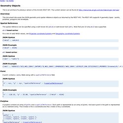
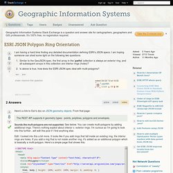
The current version can be found at Overview This document discusses the JSON geometry and spatial reference objects as returned by the REST API. The REST API supports 4 geometry types - points, polylines, polygons and envelopes. Spatial Reference The spatial reference can be specified using a well-known ID (wkid) or well-known text (wkt). Wkid based syntax: For a list of valid WKID values, see Projected coordinate Systems and Geographic coordinate Systems. EsriJSON to GeoJSON (experimental) ESRI JSON Polygon Ring Orientation. Here's a link to Esri's doc on JSON geometry objects.
From that page: The REST API supports 4 geometry types - points, polylines, polygons and envelopes. Sounds like multi-polygons are not supported. See below. You can create multi-polygons by adding additional rings. Edit: I looked into this a bit more. If you load that page, the first ring is the square with two holes. Www.esri.com/library/whitepapers/pdfs/shapefile.pdf. Geojson-utils/jsonConverters.js at master · Esri/geojson-utils. Esri/Terraformer. C# ArcGIS Geometry JSON to WKT. Can ArcPy's AsShape be used with GeoJSON FeatureCollection of Polygons with Labels? Current community your communities Sign up or log in to customize your list. more stack exchange communities Stack Exchange sign up log in tour help Geographic Information Systems Ask Question Take the 2-minute tour × Geographic Information Systems Stack Exchange is a question and answer site for cartographers, geographers and GIS professionals.
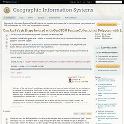
Can ArcPy's AsShape be used with GeoJSON FeatureCollection of Polygons with Labels? 4 Answers active oldest votes Your Answer Sign up or log in. GeoJSON Specification. 1.
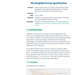
Introduction GeoJSON is a format for encoding a variety of geographic data structures. A GeoJSON object may represent a geometry, a feature, or a collection of features. GeoJSON supports the following geometry types: Point, LineString, Polygon, MultiPoint, MultiLineString, MultiPolygon, and GeometryCollection. ArcGIS API for JavaScript. ArcGIS Help 10.1 - Polygon (arcpy) Summary A Polygon object is a closed shape defined by a connected sequence of x,y coordinate pairs.
Discussion In many geoprocessing workflows, you may need to run a specific operation using coordinate and geometry information but don't necessarily want to go through the process of creating a new (temporary) feature class, populating the feature class with cursors, using the feature class, then deleting the temporary feature class. Geometry objects can be used instead for both input and output to make geoprocessing simpler.
Geometry objects can be created from scratch using Geometry, Multipoint, PointGeometry, Polygon, or Polyline classes. Syntax Polygon (inputs, {spatial_reference}, {has_z}, {has_m}) Properties Method Overview Methods. Geometry Visualizer. Esri/geometry-api-java.