
L'extraordinaire carte qui montre les évolutions de populations en Europe. Une Europe rouge contre une Europe bleue ?
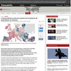
Cette carte, de l'Institut fédéral de recherche sur le bâtiment, les affaires urbaines et le développement spatial (BBSR, Allemagne), montre l’évolution démographique entre 2001 et 2011 de chaque commune en Europe. Cette carte publiée en 2015 donne une vision assez nette des régions en croissance démographique et celles en déclin. L’Europe se divise assez nettement en zones rouges (l’ouest, avec notamment la France, l’Irlande, le Nord-Est de l’Ecosse…) et bleues (Europe de l’Est, avec notamment une grande partie de l’Allemagne). Si la carte montre bien les grandes évolutions démographiques du continent, son niveau de détail permet d’analyser, dans chaque pays, mais aussi dans chaque région, les zones gagnantes et les zones perdantes. Cartes thématiques, fonds de cartes, schémas et croquis. Histoire de la cartographie.
Cartographie interactive - webmapping - statistiques - carte de France - atlas - Géoclip. La carte. Untitled. Visualizing Friendships. 2011 à la carte. Tour d'horizon des meilleures cartes de 2011 par l'auteur du site anglais de datavisualisation Spatial Analysis.
Des connections sur Facebook aux collaborations scientifiques, tout se cartographie ! Alors que 2011 touche à sa fin, il est bon de revenir sur cette année déterminante pour la cartographie et l’analyse spatiale. Les données géographiques se sont massivement ouvertes, et ont été rendues largement accessibles, conduisant à la production presque quotidienne de cartes inédites et intéressantes. L’usage croissant de technologie telle que les Google Fusion Tables a rendu la cartographie des données plus facile que jamais. Le nombre de cartes affligeantes est malheureusement également en augmentation – en grande partie en raison de la préférence du web pour la projection de Mercator et les “push-pins” (“punaises”).
Pour trouver l’inspiration pour une nouvelle année de cartographie, et sans classement particulier, voilà le Best Of 2011 de l’analyse spatiale. Voyage dans la galaxie. Language communities of Twitter. 539 - Vive le tweet! A Map of Twitter's Languages. What a joy these maps are to behold.

It’s as if someone took one of those composite satellite maps - you know, impossibly showing the whole world at night, the darkness broken by hubs and strings of artificial light (1) - and gave it the power of speech. For the riot of colours on these maps correspond to the diversity of languages spoken, or rather: typed, on Twitter. D-maps.com : cartes géographiques gratuites, cartes muettes gratuites, cartes vierges gratuites, fonds de cartes gratuits.
Atlas interactifs. Geographicus : Tous les messages sur geographicus. Bases de données - Cartes interactives. Document sans titre. ATLAS HISTORIQUE - Cartotheque. A la demande de certains fidèles internautes de ce site, Atlas-historique.net a décidé de vous proposer une cartothèque de fonds de cartes muettes tirés de ce même site.

Ces fonds sont au format pdf pour une meilleure résolution et surtout pour une meilleure impression des documents. En effet, cette cartothèque a surtout pour objectif de fournir aux lecteurs de ce site des fonds de cartes imprimables pour que ces dernières puissent être réutilisées, notamment dans le cadre d'un support de cours pour les enseignants et leurs élèves (voir les conditions d'utilisation).
Tout comme cet atlas n'a pas pour vocation d'être exhaustif, cette cartothèque ne l'est pas non plus. Il se peut donc que l'objet de vos désirs ne se trouve pas ici, mais vous pourrez peut-être le trouver en jetant un coup d'œil à ces sites : • sites payants - Geoatlas et son site dédié à la France. - Mapas vectoriales (en espagnol). - Mountain High Maps (en anglais). - Intercarto quelques ressources sont gratuites. Histoire et cartes de l’Europe au XIXe siècle : Congrès de Vienne, Printemps des peuples, triomphe des nationalités…
Le Congrès de Vienne 1814-1815 Au cours du Congrès de Vienne, les quatre grands vainqueurs de la France - la Prusse, l’Autriche, la Russie et le Royaume-Uni - redessinent la carte politique de l’Europe et tentent de clore l’épisode ouvert par la révolution française.

Les premières contestations du Congrès de Vienne La carte de l'Europe issue du Congrès de Vienne est très vite contestée et le tsar de Russie Alexandre Ier propose aux puissances européennes de coopérer dans le cadre de la Sainte Alliance pour conjurer toute remise en cause de l'ordre établi. L’indépendance de la grèce En 1821, les Grecs entament leur guerre d’indépendance contre les Ottomans. L’indépendance de la Belgique Le Royaume des Pays-Bas dessiné lors du Congrès de Vienne éclate en 1830. La question polonaise Les grandes étapes du démantèlement de la Pologne qui a connu son apogée aux XVème et XVIème siècles. L’autonomie de la Serbie Quelques repères sur l’histoire du royaume serbe depuis le XIIème siècle. L’affaire des duchés. Atelier de Cartographie.