
The First Google Maps War. Borderlines explores the global map, one line at a time.
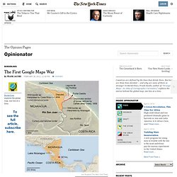
Did Google Maps almost cause a war in 2010? On Nov. 3 of that year, Edén Pastora, the Nicaraguan official tasked with dredging the Rio San Juan, justified his country’s incursion into neighboring Costa Rica’s territory by claiming that, contrary to the customary borderline, he wasn’t trespassing at all. For proof, he said, just look at Google Maps [1]. The digital atlas had indeed placed the eastern end of the border between the countries to the south of the generally accepted line, providing Nicaragua with a territorial gain of a few square miles. How Islamic inventors changed the world - Science - News.