background preloader

Opened 9/3/2012

Facebook Twitter

Making Streets for Walking: Dan Burden on Reforming Design Standards. A template for an urban street in "Designing Walkable Urban Thoroughfares. " Source: Claire Vlach, Bottomley Design & Planning. One of the foundational documents in our country's history of car-centric street design is what's known as the Green Book. These engineering guidelines, which have been published in various editions by the American Association of State Highway and Transportation Officials (AASHTO) since the 1930s, are only "green" if you're looking at the cover. "We should take control of our streets. If 85 percent of our motorists are driving faster than we want them to, then we need to redesign the street. " Inside, the Green Book codifies an anti-urban design approach that transportation engineers have followed to disastrous effect in American cities and towns, creating wide streets where cars rule, speeding is the norm, and the greenest modes of travel have no place.

Fortunately, these engineering standards are shifting. If, as U.S. Here's the first part of our interview: Can We Design Cities for Happiness? Happiness itself is a commons to which everyone should have equal access. That’s the view of Enrique Peñalosa, who is not a starry-eyed idealist given to abstract theorizing. He’s actually a politician, who served as mayor of Bogotá, Colombia, for three years, and now travels the world spreading a message about how to improve quality-of-life for everyone living in today’s cities.

Peñalosa’s ideas stand as a beacon of hope for cities of the developing world, which even with their poverty and immense problems will absorb much of the world’s population growth over the next half-century. Based on his experiences in Bogotá, Peñalosa believes it’s a mistake to give up on these cities as good places to live. “If we in the Third World measure our success or failure as a society in terms of income, we would have to classify ourselves as losers until the end of time,” declares Peñalosa. Credit: Felipe Andrade Transforming Bogotá Credit: Carlos Felipe Pardo Quality of Life = Common Wealth. What is Post-Utopian Urbanism? Urbanism, Utopias, Urbatopia (guest post 1/3) « la dialectique casse des briques.

When “God is dead, the author is dead, history is dead, only the architect is left standing” (Koolhaas, 2002: 18) without utopias, what (or who) is actually left for the planning and development of our cities? Besides its appeal to a longue durée analysis, the topic of urbanism and utopia – and their links, of course – is today rather fashionable, whether one speaks of current exhibitions, critical insights on the idea of a capitalist Utopia, or even indirectly among the latest parliamentary reports. In this series of three guests posts we will explore the definition of a Post-Utopian Urbanism, on the basis of various readings ranging from Lefebvre to recent writings of Jameson and Rem Koolhaas, and to a great extent indebted to David Harvey’s seminal analysis of the links between capitalist transformation and our (post)modern perception of space and time (1989).

The definition of Utopia, the City, and the contextualisation of their problematic encounter is a controversial undertaking. July 2011. The next essay in the Landscape Urbanism Reader, following 'Terra Fluxus' and the initial 'Reference Manifesto' is a longer essay by Waldheim exploring the idea that landscape is most suited to the modern metropolis, being "uniquely capable of responding to temporal change, transformation, adaptation, and succession... a medium uniquely suited to the open-endedness, indeterminacy, and change demanded by contemporary urban conditions. " (39) This idea could be considered one of the formative structures on which landscape urbanism is built, explained by many writers as a response the failings of architecture and urban design to cope with the complexity of the urban situation, leading to Waldheim's apt, but somewhat hyperbolic statement that "the discourse surrounding landscape urbanism can be read as a disciplinary realignment in which landscape supplants architecture's historical role as the basic building block of urban design.

" (37) :: Lower Dons - River + City + Life by Stoss LU. Suburbia. De-Urbanization as Defense Against Alien Invasion The previews for the new Rogue movie 'Skyline' made me think of a possible benefit from the general dispersion of urban populations. As shown in the film, the prototypical invasion is preceded by.the traditional 'parking' of ships above all of the 'worlds cities' that has been echoed in sci-fi genres since, well, forever. :: image via shockya.com This focus on urban areas - and the concept of dense aggregation of populations makes us vulnerable to attack by aliens due to the ease in which they can focus their energy in a few areas, versus trying to conquer and occupy the globe 'block-by-block' if you will. The energy to root out the distributed population around the world would have been difficult, if not impossible. :: image via coming attractions With the ever increase move towards cities, we have tipped the scales as to our virtual ease of invasion, which has likely caught the attention of alien cultures. :: image via What If 1.

Density of the Dead. A little cross-post from the Veg.itecture blog, where the concept of a vertical cemetery in Mumbai 'Vegitecturally Vertical Cemetery' was presented as a way to satisfy cultural expectations while efficiently utilizing scarce urban land. As we've become less likely to cross program or use cemeteries as quasi-public parks and open space - these areas (while heavily weighed down with much baggage) are literally urban dead space. A diagram of the amount of comparative density on a plot of land shows the inefficiencies of this horizontal infrastructure for disposal - at a density of 4000 bodies to 100 acres. Using similar mapping/datascape techniques of MVRDV (some info here) - it would be interesting to posit the acutal spatial impact of such a land use - even factoring in the differing cultural aspects. Even as we densify the planet, there's still a bunch of land in this big world of ours - at a rate of 1000 s.f. per body - that land surplus is gonna go away quickly.

1959 Film from ULI and National Association of Homebuilders Warns of Urban Sprawl. Cluster zonning. Planned unit development. Omar nagati cluster. Most Americans Want a Walkable Neighborhood, Not a Big House - Lifestyle. Urban Planning and Design - Lesson 2 - 23.03.2009. Introduction to research in urban planning and design. Building up a strong argument. Complex Cities Graduation Studio TU Delft. Activeliving. Mike biddulph, "introduction to residential layout"

St. George’s East: S.W.O.T. Analysis | RUDI - Resource for Urban Design Information. St.George’s East has been included within this guidance in an attempt to re-unite the area with the City Centre and reduce the severance effect of the Central Ring Road. The following strengths, weaknesses, opportunities and threats have been identified. Click image to enlarge St George's East: Area Analysis 7.3 St George’s East St.George's East: Development Opportunities Within St George’s East opportunities exist for both redevelopment and conversion.

Key Redevelopment Opportunities The City Council will seek: The comprehensive redevelopment of St. Key Conversion Opportunities The City Council will seek the reuse and refurbishment of: The disused railway building on Samuel Street. On the following pages detailed guidance is provided for the individual sites as shown on the plan opposite. Key Pedestrian/Public Open Space Improvements The City Council will seek improvements St. Fox Street Site (Site 21) Potential Uses and Outputs: Concerns: Noise and pollution St. Key Outputs. Building a Presentation from Start to Finish with LayOut. City Views. Today, Jane Jacobs is revered as North America's great expert on cities and the way they work. But 40 years ago, when her masterpiece The Death and Life of Great American Cities was first published, she was assaulting -- and shattering -- the fundamental tenets of urban planning.

That book was part literature, part journalism, and part sociology; it looked at cities from the sidewalks and street-corners up, not from the Ivory Tower down. Healthy cities, Jacobs argued, are organic, messy, spontaneous, and serendipitous. They thrive on economic, architectural, and human diversity, on dense populations and mixed land uses -- not on orderly redevelopment plans that replaced whole neighborhoods with concrete office parks and plazas in the name of slum clearance or city beautification. Jacobs has no professional training and only a high school diploma. Jacobs' subsequent books have been just as revolutionary, if not always as widely read. Jacobs, who turns 85 this year, is as sharp as ever. الانتحار. Jane Jacobs. "Automobiles are often conveniently tagged as the villains responsible for the ills of cities and the disappointments and futilities of city planning.

But the destructive effects of automobiles are much less a cause than a symptom of our incompetence at city building . . . The simple needs of automobiles are more easily understood and satisfied than the complex needs of cities, and a growing number of planners and designers have come to believe that if they can only solve the problems of traffic, they will thereby have solved the major problems of cities. Cities have much more intricate economic and social concerns than automobile traffic. How can you know what to try with traffic until you know how the city itself works, and what else it needs to do with its streets? You can't. " The uses of sidewalks: safety "A well-used city street is apt to be a safe street. "First, there must be a clear demarcation between what is public space and what is private space. The uses of sidewalks: contact.

بالفيديو.. غزلان: كانت ثقتنا فى "العسكرى" مطلقة.. لكننا تعلمنا و"كفاية اللى حصل النهاردة" Week 11: Infographics « The World is Flat. Information graphics make lives easier! When I was in secondary school, Mathematics used made me cry because numbers confused me entirely. I only looked forward to charts and graphs section in Statistics since I found reading graphs to be very easy. Bar graphs, line graphs and Pie charts are straightforward with information, visually simulating and requires less time to read. These graphs are infographics that ‘combine the individual satisfication of words with the emotional power of visual’ (Lester, 1995, 194). Infographics is a hybrid of graphics and information gathered from numbers and words to display data.

For example; The Histogram taken from GTP iCommerce is much more attractive to look at compare the list of numbers beneath it. ‘The power of a graphics representation of empirical data lies in its explanation of complex processes by an immediate visual image, ‘ (Lester, 1995, 195) As Lester mentioned, visuals play an important role to simplify empirical data. Information gathered: الجوهر العلماني للإسلام. The World is Flat. «خيرت الشاطر».. كلمة السر فى صفقة الإفراج عن الأمريكان الـ19 ماكين زار مكتب رجل الإخوان القوى والحزب غيرموقفه من القضية بعدها. خيرت الشاطر كتب - محمد إسماعيل اتهمت مصادر سياسية المهندس خيرت الشاطر نائب المرشد العام لجماعة الإخوان المسلمين بالتورط فى صفقة السماح للمتهمين الأمريكيين الـ19 بالسفر إلى الخارج قبل الانتهاء من نظر القضية..

على خلفية اللقاء غير المعلن الذى جرى فى مكتب الشاطر مع جون ماكين عضو مجلس الشيوخ الأمريكى، ورئيس مجلس إدارة المعهد الجمهورى الدولى. وألمحت مصادر مطلعة بالجماعة إلى أن هناك اعتقادا بأن خيرت الشاطر، وافق على طلب ماكين فى اللقاء الذى استمر لمدة ساعة من باب توطيد العلاقات مع الولايات المتحدة الأمريكية، حرصا على طمأنتها تجاه توجهات الجماعة فى الشرق الأوسط خلال الفترة المقبلة. وأوضح عيسى أن هناك إشكالية فى اتصالات الإخوان بالأطراف الخارجية، حيث كان من المفترض أن يلتقى ماكين بالدكتور محمد مرسى رئيس حزب الحرية والعدالة، وليس بالمهندس خيرت الشاطر نائب المرشد العام للجماعة، وأضاف: «نلاحظ أن قيادات الإخوان المسلمين، تتحدث كما لو كانوا هم المسؤولون عن المكتب السياسى للحزب، وأن الحرية والعدالة ليس سوى كيان تابع لمكتب الإرشاد والمرشد ونوابه».

مطعم «زفريون» حكاية عشق يونانية إسكندرانية عمرها 80 عاما, تسمع فيه «الثرثرات» اليونانية والإنجليزية والفرنسية والإسبانية والعربية بلهجاتها المختلفة الإسكندرية: داليا عاصم على بقعة هادئة بشاطئ ضاحية أبو قير في مدينة الإسكندرية يقبع مطعم «زفريون» اليوناني. تتسلل منه رائحة الجمبري المشوي المختلطة بعبق اليود الذي ترسله أمواج البحر على المكان وعلى الحارات المحيطة بحكاياتها وذكرياتها عن الإسكندرية العتيقة ببساطتها ورقتها وعذوبتها. خطوات تقطعها وسط المباني الضئيلة ذات الطابقين حتى تصل إلى مبنى مميز على ساحل الأبيض المتوسط، يكتسي بألوان العلم اليوناني الأبيض والأزرق، حيث يمكنك الاستمتاع بأشهى وجبة بحرية، مستمتعا بمذاق عند أطراف البحر الأبيض المتوسط اللامتناهي. وأمام هذا المطعم البسيط والمتفرد في ديكوراته ستجد سيارات فارهة تصطف في مكان مخصص لها، ويلقاك نادل مهذب يساعدك على وضع سيارتك لتبدأ متعتك مع الأسماك الطازجة.

وبمجرد أن تختار طاولتك ستقوم برحلة في رحاب «زفريون» الفسيح لانتقاء ما تلتهمه من أصناف المأكولات البحرية من الأسماك الطازجة والمحار واختيار طريقة طهيها. «كان في استوريا قصة كبير خالص، وظروف كتير وقصص ميكفيش سنة علشان نحكيه». Demographic trends explaining population trends. NOTE: The UN data for births, deaths and migration are presented at the UN data site as births, deaths and migration for 5 year intervals. This actually means the average number of births, deaths and migrations per year over that 5 year interval. So for example, the 61,715,230 births in Asia for 1950-1955 means an average of 61,715,230 births per year in Asia during 1950-1955. See further explanation in the Data section below. Table 3 Net Natural Change (births - deaths) (Last 2 Columns - Special Case of Eastern Europe and Europe - Eastern Europe) Source: World Population Prospects: The 2010 Revision, United Nations Population Division, UN Data, Each 5 year period represents an average per year over that 5 year period.

A. Beyond Economic Growth Student Book, III. Population change at regional level. B. Source: World Population Prospects: The 2010 Revision, United Nations Population Division, UN Data, Appendix Table 1. Appendix Table 2. World demographic trends. Brief Review of World Demographic Trends - Population Click here to go back to the reports page.
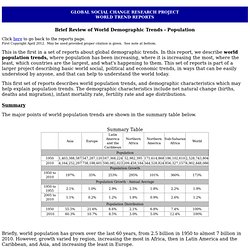
First Copyright April 2012. May be used provided proper citation is given. See note at bottom. This is the first in a set of reports about global demographic trends. In this report, we describe world population trends, where population has been increasing, where it is increasing the most, where the least, which countries are the largest, and what's happening to them. This first set of reports describes world population trends, and demographic characteristics which may help explain population trends. The major points of world population trends are shown in the summary table below. Summary Table Briefly, world population has grown over the last 60 years, from 2.5 billion in 1950 to almost 7 billion in 2010. In addition, while population is still increasing in all regions, the increase has been slowing, and the slowing varied by region.

Detailed descriptions of world population trends Charts. Urban density debate. Ited Nations Statistics Division - Demographic and Social Statistics. The Great Density Debate. The Design-Density Debate - Discussing the role of Architecture to shape Density through Design. SPACEMATE® | Visually and Mathematically Examining Space, Density, and Urban Form | The Architecture Report. Recent changes in urban design and planning practice (e.g., large scale projects, very long time spans, privatization, an unpredictable future, and increasingly complex programs) require strategies that enable planners, politicians and the public to regain influence on relevant aspects of the quality of the urban environment.

At the same time, such a strategy must leave designers and developers enough flexibility and freedom to realize a plan. The concept of density, as expressed in the Spacemate method, can be used in such a strategy. This method makes it possible to describe an urban environment by using a set of density variables (FSI, GSI, OSR and L). These quantitative aspects can be used both to describe and characterize, as well as prescribe different urban environments. Spacemate thus enables different actors in the design and planning process to relate different programmatic demands to different spatial solutions.

Floor Space Index (FSI): Ground Space Index (GSI): Layers (L): (2) SPACEMATE® Presentation | KTH 27 October 2011. The Architecture Report. Hassan fathy planning.