
Global Digital Elevation Model (ETOPO2) The data are provided by multiple, third party data vendors under license to ESRI for inclusion on ESRI Data & Maps for use with ESRI® software.

Each data vendor has its own data licensing policies and may grant varying redistribution rights to end users. Please consult the redistribution rights below for this data set provided on ESRI Data & Maps. As used herein, “Geodata” shall mean any digital data set consisting of geographic data coordinates and associated attributes. The redistribution rights for this data set: Redistribution rights are granted by the data vendor for hard-copy renditions or static, electronic map images (for example, .gif, .jpeg,) that are plotted, printed, or publicly displayed with proper metadata and source/copyright attribution to the respective data vendor(s).
The terms and conditions below apply to all the data sets provided on ESRI Data & Maps. Index of /mgg/global/relief/ETOPO2. ETOPO1 Global Relief. ETOPO1 is a 1 arc-minute global relief model of Earth's surface that integrates land topography and ocean bathymetry.
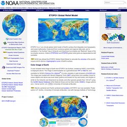
It was built from numerous global and regional data sets, and is available in "Ice Surface" (top of Antarctic and Greenland ice sheets) and "Bedrock" (base of the ice sheets) versions. Historic ETOPO2v2 and ETOPO5 global relief grids are deprecated but still available. NCEI has utilized the ETOPO1 Global Relief Model to calculate the volumes of the world's oceans and to derive a hypsographic curve of Earth's surface.
Color Image of Earth A color shaded-relief image of Earth from ETOPO1 Ice Surface, created by NGDC (now NCEI), is displayed above. Atlantic-centered and Pacific-centered wall posters of ETOPO1 are now available. Available Versions of the Grid ETOPO1 Ice Surface: Grid of Earth's surface depicting the top of the Antarctic and Greenland ice sheets.ETOPO1 Bedrock: Grid of Earth's surface depicting the bedrock underneath the ice sheets. Horizontal Datum Custom Grids. NGDC/MGG-Global Land One-km Base Elevation Project (GLOBE Topography) Other Sources and Reviews of DEMs: The Global Land One-km Base Elevation Project (GLOBE) Task Team was established by the Committee on Earth Observation Satellites.

It was part of Focus I of the International Geosphere-Biosphere Programme - Data and Information System. For more information, please see A Brief History of GLOBE in the project report. How to cite the Global Land One-km Base Elevation Project (GLOBE) database: GLOBE Task Team and others (Hastings, David A., Paula K. These project web pages were created by and are hosted by the World Data Service for Geophysics, Boulder. NGA Raster Roam. Index of /srtm/version2_1/SRTM3. EROS. Digitales Geländemodell. Es gibt in der wissenschaftlichen Literatur keine allgemeingültige Definition der Begriffe digitales Höhenmodell (DHM) und digitales Geländemodell (DGM).

International gebräuchlich ist auch digitales Terrainmodell (DTM). Repräsentierte Oberfläche eines DOMs (rot) und eines DGMs (türkis) Das digitale Oberflächenmodell (DOM) (engl. digital surface model) repräsentiert die Erdoberfläche (Grenzschicht Pedosphäre - Atmosphäre) samt aller darauf befindlicher Objekte (Bebauung, Straßen, Bewuchs, Gewässer usw). Hingegen repräsentiert das digitale Geländemodell (engl. digital terrain model) die natürliche Erdoberfläche (vgl.
Li u. a. 2005, AdV 2004, siehe Abbildung). Die Definitionen des Begriffes digitales Höhenmodell (engl. digital elevation model) unterscheiden sich stark bezüglich der repräsentierten Oberfläche. Definitionen[Bearbeiten] Digitales Geländemodell[Bearbeiten] 3D-Visualisierung eines digitalen Geländemodells am Beispiel einer Schlucht auf dem Mars Digitales Höhenmodell[Bearbeiten] .